
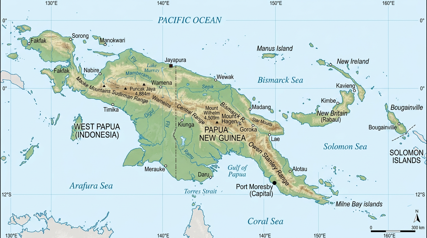
Papua New Guinea intrigues with its varied landscapes and incredible ethnic mosaic. Nestled north of Australia, this island nation attracts both geography enthusiasts and travelers curious to discover remote and preserved territories. Diving into a map of Papua New Guinea offers a fascinating glimpse of its islands, its capital Port Moresby, as well as its many colorful cities and regions. Let yourself be guided through this exceptional territory, analyzing both its political map and its administrative specificities.
Geography of papua New Guinea: a country of islands and diversity
Spanning the eastern half of the main island of New Guinea and including multiple neighboring archipelagos, Papua New Guinea offers a truly unique geography. At a glance on the map, it is clear that the country resembles no other.
The rugged interior topography contrasts with the coasts dotted with turquoise lagoons and wild beaches. The relief is dominated by an imposing mountain massif that rises over 4,000 meters, while some islands barely emerge above sea level. The population distribution partly reflects these contrasts, with communities scattered between mountains, tropical forests, and isolated coastlines.
The large island and its natural regions
Papua New Guinea occupies the eastern half of the island of New Guinea. This vast landmass is divided into several natural regions, each with its own identity. The Highlands, known for their cool climate and traditional cultures, stand out, as do the lush coastal plains with their warm and humid climate.
Deep valleys, carved by rushing rivers, sometimes serve as natural borders between different linguistic or tribal communities. These regional distinctions are reflected on every administrative or political map of the country, where more than 800 languages are spoken.
The archipelago and small peripheral islands
Surrounding the main landmass are a myriad of islands and small archipelagos, such as those in the Bismarck Sea, the Trobriand Islands, and the Louisiades. All these lands benefit from lush vegetation and often shelter populations still living according to ancestral ways of life.
Papua New Guinea thus brings together a multitude of worlds in a single country. The maps showing the distribution of islands allow visualization of these spaces distant from each other, yet united by a shared contemporary history.
Borders and strategic positioning of Papua New Guinea
Observing a map also helps better understand the unique geographical position of Papua New Guinea on the international stage. Bordering Indonesia, the country acts as a bridge between Southeast Asia and Oceania.
Its vast sea access also offers valuable maritime routes for regional trade, while some of its immediate neighbors like Australia are among its main economic and political partners.
The Indonesian border: a cultural and historical demarcation
The only true land border of Papua New Guinea separates it from the Indonesian province of West Papua. This boundary generally follows the mountain ridge that splits the island in two. On one side, Indonesian administration; on the other, an independent and multiparty government.
On a political map, this border line takes on an almost symbolic dimension. It recalls the persistent differences between two peoples linked by a common land but divided by historical and administrative choices.
Complex maritime borders to the east and south
To the south, Papua New Guinea has only a fairly narrow sea arm between it and the northern tip of Australia. To the east, it is mainly maritime borders that separate it from the Solomon Islands and other Oceanian micro-states.
These delimitations sometimes pose challenges regarding fishing and resources, as can be seen by consulting a detailed administrative map incorporating exclusive economic zones. For discerning observers, this highlights how much Papua New Guinea plays a crossroads role in the South Pacific.
Administrative and political mapping: understanding the country’s organization
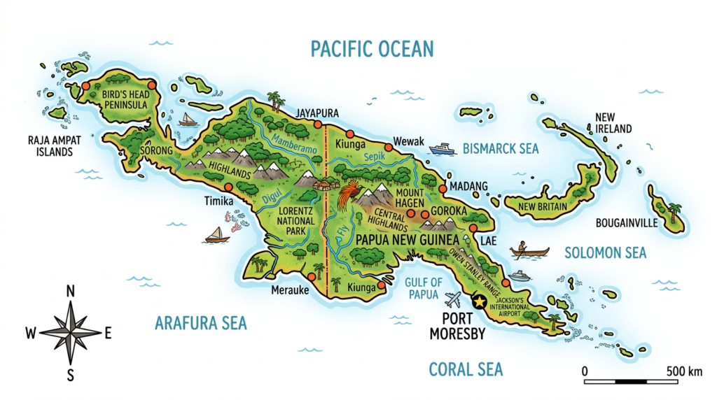
Delving deeper into the geography of this territory also involves exploring its division into regions, provinces, and districts. An administrative map helps better understand how the territory is structured, while a political map provides an overview of the distribution of the different regional entities, essential for understanding internal dynamics.
Papua New Guinea currently has 22 provinces, including the capital Port Moresby, which benefits from a special status linked to its institutional and economic weight. Each province is subdivided into districts and then into local government units, a structure inherited from British and Australian colonization.
Regional organization: provinces and provincial capitals
Each province has its own local capital, often located in an important town of the concerned region. For example, the Western Highlands province has Mount Hagen as its administrative center, while Alotau serves as the capital for Milne Bay province.
This regional organization is reflected on every political map and guides the decentralization policy carried out since independence. Some provinces have gained increased autonomy to better manage internal diversity, notably Bougainville, which enjoys a special status.
Port Moresby: the capital and political center
The capital Port Moresby always appears prominently on current maps. This coastal metropolis concentrates the main national institutions, most of the modern infrastructure, as well as neighborhoods in constant development.
Port Moresby plays a pivotal role in the local economy and hosts the majority of the country’s diplomatic exchanges. Its influence far exceeds its administrative borders, making it a true hub in Oceania.
Discovering major cities and urban particularities
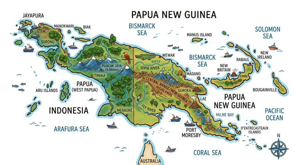
Beyond Port Moresby, Papua New Guinea harbors an urban fabric in full transformation despite the predominance of rural villages. Each major town has a very particular atmosphere, resulting from the blend of ancient traditions and recent external influences.
In the Papuan landscape, towns form essential centers of attraction for commerce, education, and health. On an administrative map, they constitute strategic points connected by sometimes difficult-to-access road axes, depending on the seasons.
- Lae: the country’s second largest urban area and main industrial port. It has strong port and commercial activity.
- Mount Hagen: in the heart of the Highlands, famous for its lively markets and dynamic cultural life.
- Madang: a coastal town appreciated for its pleasant lifestyle and diving spots.
- Kokopo: new regional capital following the volcanic eruption that destroyed Rabaul.
- Wewak: heavily oriented towards fishing and cocoa cultivation.
Urbanization remains moderate throughout the territory, limiting the emergence of large megacities. However, some towns are experiencing rapid growth, attracting new inhabitants from remote rural regions, gradually transforming urban centers.
Practical use of maps: tools for travelers and geography enthusiasts
Having an updated map of Papua New Guinea is essential for anyone wishing to prepare a trip or understand the local geopolitical balances. Depending on the needs, different types of maps offer complementary information allowing for orientation, anticipating movements, and enriching the discovery of the country.
Traditionally, there are three main families of maps commonly used to explore this territory:
- Political map: highlights the administrative structure with its provinces, capitals, and districts. Valuable for having an overview of the country’s governance.
- Administrative map: details the internal organization, especially for planning a route connecting several regions or carrying out official procedures.
- Physical map: ideal for hiking enthusiasts or scientific missions, as it highlights mountains, volcanoes, rivers, and forests.
Whatever your goal, choosing a suitable map promises a clear and precise view of Papua New Guinea and its unique characteristics.
Towards a renewed discovery of Papua New Guinea through cartography
Exploring Papua New Guinea through its maps opens a world of multiple interactions, where each region reveals new promises. Whether it is to travel through the capital Port Moresby, follow the coasts of forgotten islands, or traverse the mountainous interior, every corner benefits from being understood in the light of its political or administrative map.
In this approach, the map is not just a simple visual aid; it becomes the guiding thread of an itinerary rich in human encounters and natural discoveries. Taking care in your exploration often begins with a well-chosen map. This is a first step to better grasp the beauties and challenges of this vast Oceanian country.
FAQ: Papua New Guinea map
Online mapping services provide general views, but it is recommended to supplement your search with specialized maps available on local travel sites. These documents often offer more precise details on transport infrastructure.
Most maps indicate major regions and urban centers, but remote areas are often poorly detailed. The country’s complex topography makes navigation difficult without prior knowledge of the terrain.
Yes, it is an essential safety measure given the limited network coverage outside of cities. Downloading your travel areas before you leave ensures access to critical geographic information.
