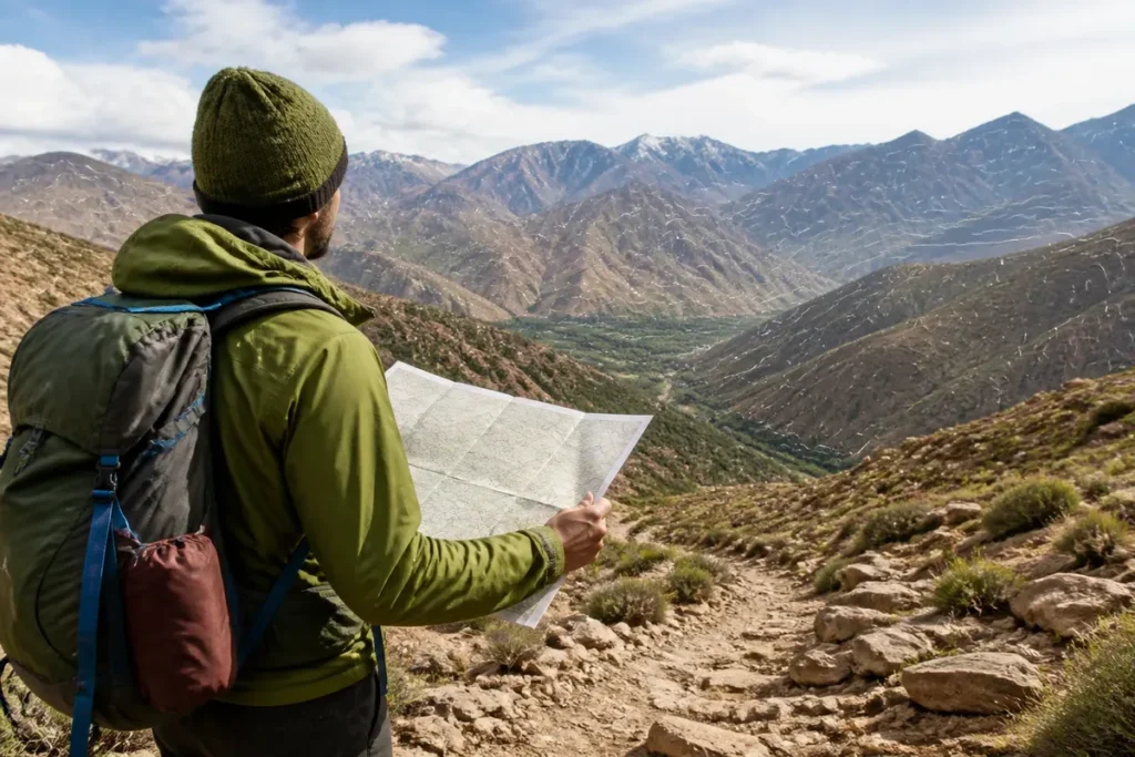
📋 Key point: Personally, I believe that 85% of travelers underestimate the impact of altitude changes on travel times when consulting a topographic map of Morocco. However, analyzing contour lines is essential to anticipate the difficulties of mountain roads.
.synthesis h2, .synthesis .synthesis-header { font-size: 1.15em; font-weight: 700; margin-bottom: 0.6em; color: #47752c; }
.synthesis p, .synthesis li { font-size: 1em; line-height: 1.65; margin: 10px; }
.synthesis strong { color: #121e0b; }
.synthesis table { width: 100%; border-collapse: collapse; }
.synthesis th { background: rgba(91, 150, 56, 0.12); color: #47752c; text-align: left; }
.synthesis td, .synthesis th { padding: 8px 12px; border-bottom: 1px solid rgba(91, 150, 56, 0.18); vertical-align: top; }
.synthesis tbody tr:nth-child(even) { background: rgba(91, 150, 56, 0.05); }
.key-takeaways { max-width: 640px; margin: 2em auto; padding: 1.5em 1.8em; color: #1f3313; font-family: “Inter”, “Segoe UI”, sans-serif; text-align: left; position: relative; box-sizing: border-box; background: #f2f7ef; border: 1px solid #5b9638; border-left: 6px solid #5b9638; border-radius: 12px; box-shadow: 0 8px 24px rgba(251, 191, 36, 0.15); }
.key-takeaways h2, .key-takeaways .key-takeaways-header { font-size: 1.15em; font-weight: 700; margin-bottom: 0.6em; color: #47752c; }
.key-takeaways p, .key-takeaways li { font-size: 1em; line-height: 1.65; margin: 10px; }
.key-takeaways strong { color: #121e0b; }
.key-takeaways ul { list-style: none; padding-left: 0; }
.key-takeaways li { margin: 0.45em 0; padding-left: 0.2em; }
.mg-callout{margin:1.5em 0;padding:.9em 1.1em;border:1px solid;border-left-width:4px;border-radius:10px;font-size:.97em;line-height:1.65}.mg-callout>:first-child{margin-top:0}.mg-callout>:last-child{margin-bottom:0}.mg-callout__label{display:block;margin:0 0 .35em;font-weight:700;font-size:.82em;letter-spacing:.03em;text-transform:uppercase}.mg-callout__label::before{margin-right:.45em;font-size:1.05em;vertical-align:-.06em}.mg-callout–info{background:#eff6ff;border-color:#bfdbfe;color:#1e3a5f}.mg-callout–info .mg-callout__label{color:#2563eb}.mg-callout–info .mg-callout__label::before{content:”\2139\FE0F”}.mg-callout–tip{background:#f0fdf4;border-color:#bbf7d0;color:#14532d}.mg-callout–tip .mg-callout__label{color:#15803d}.mg-callout–tip .mg-callout__label::before{content:”\1F4A1″}.mg-callout–warning{background:#fffbeb;border-color:#fde68a;color:#7a4a10}.mg-callout–warning .mg-callout__label{color:#b45309}.mg-callout–warning .mg-callout__label::before{content:”\26A0\FE0F”}.mg-callout–danger{background:#fef2f2;border-color:#fecaca;color:#7f1d1d}.mg-callout–danger .mg-callout__label{color:#dc2626}.mg-callout–danger .mg-callout__label::before{content:”\1F6D1″}.mg-proscons{display:grid;grid-template-columns:1fr 1fr;gap:16px;margin:1.5em 0}@media(max-width:560px){.mg-proscons{grid-template-columns:1fr}}.mg-proscons__col{padding:.9em 1.1em;border:1px solid;border-radius:10px}.mg-proscons__title{display:flex;align-items:center;gap:.4em;margin:0 0 .5em;font-weight:700;font-size:.9em;letter-spacing:.02em}.mg-proscons__col ul{margin:.3em 0 0;padding-left:1.15em}.mg-proscons__col li{margin:.3em 0;line-height:1.55}.mg-proscons__col–pro{background:#f0fdf4;border-color:#bbf7d0;color:#14532d}.mg-proscons__col–pro .mg-proscons__title{color:#15803d}.mg-proscons__col–pro .mg-proscons__title::before{content:”\2705″}.mg-proscons__col–con{background:#fef2f2;border-color:#fecaca;color:#7f1d1d}.mg-proscons__col–con .mg-proscons__title{color:#dc2626}.mg-proscons__col–con .mg-proscons__title::before{content:”\274C”}ol.mg-steps{list-style:none!important;counter-reset:mgstep;margin:1.6em 0;padding-left:0!important}ol.mg-steps>li.mg-steps__item{counter-increment:mgstep;list-style:none!important;padding-left:0!important;padding-bottom:1.4em}ol.mg-steps>li.mg-steps__item:last-child{padding-bottom:0}ol.mg-steps>li.mg-steps__item>:last-child{margin-bottom:0}ol.mg-steps>li.mg-steps__item>.mg-steps__title{margin:0 0 .25em;font-weight:600}ol.mg-steps>li.mg-steps__item>.mg-steps__title::before{content:counter(mgstep) “. “;opacity:.45;font-weight:500;font-variant-numeric:tabular-nums}ol.mg-steps>li.mg-steps__item:not(:has(.mg-steps__title))::before{content:counter(mgstep) “. “;opacity:.45;font-weight:500;font-variant-numeric:tabular-nums}.mg-kpis{display:grid;grid-template-columns:repeat(auto-fit,minmax(140px,1fr));gap:14px;margin:1.5em 0}.mg-kpi{padding:1em .9em;border:1px solid #e5e7eb;border-radius:12px;background:#f9fafb;text-align:center}.mg-kpi__value{display:block;font-size:1.7em;font-weight:800;line-height:1.15;color:#111827}.mg-kpi__label{display:block;margin-top:.35em;font-size:.85em;color:#6b7280;line-height:1.35}
.wp-block-image,.ai-image{margin-bottom:1.75em}.wp-block-image>figcaption,.ai-image>figcaption{margin-top:.5em}
From 1/25,000, 1/50,000, or 1/100,000 scale, topographic maps of Morocco show the reliefs, altitudes, and useful elements to locate an area. To download local sheets, SIG-Maroc offers a search by region with JPG files at 1/50,000; the ANCFCC presents the official coverage at 1/25,000, 1/50,000, and 1/100,000, in vector and raster formats.

A colored map gives an immediate impression of the Moroccan mountains, plateaus, and desert areas. However, it is not enough to prepare an itinerary: you must read the scale, contour lines, legend, edition date, and coordinate system before entrusting it with a hike or a geographical analysis.
🌟 My experience: During my crossing of the High Atlas, relying solely on a classic road map caused me some cold sweats facing steep passes not marked as difficult. This misadventure taught me that a careful reading of altitude layers radically changes the planning of a journey.

| 🗺️ | Official scale: the ANCFCC lists base maps at 1/25,000, 1/50,000, and 1/100,000. |
| ⛰️ | Visible reliefs: Middle Atlas, High Atlas, Anti-Atlas, plateaus, plains, and Saharan areas appear through contours, shades, and shapes. |
| 📐 | Level of detail: the smaller the denominator, the more finely the sheet enlarges the terrain. |
| 💾 | Formats: the ANCFCC provides vector and raster products; third-party catalogs also offer local files. |
| 📍 | Search: an area can be found by region, city, sheet number, or position on an interactive map. |
| ⚠️ | Practical limit: an old or poorly georeferenced map can shift a route, road, or boundary. |
To deepen your discovery of the country, I recommend preparing your trip to Morocco to integrate this geographic data beforehand. You can also consult some tips to discover Marrakech and its immediate surroundings, or read our guide to visit Morocco as part of an unforgettable trip.
Where to find a reliable topographic map of Morocco?
🍀 Advantages
• Precise visualization of reliefs and elevation changes
• Fine understanding of exposure and slope
• Essential for safety off the beaten path
🔻 Disadvantages
• Sometimes complex reading for non-experts
• Bulkiness of large-format paper maps
• Requires regular updating of digital data
For a reference map, start with the ANCFCC catalog, then use a download portal or an interactive map according to your needs. The official source describes the series and formats; a third-party resource sometimes facilitates access to a local sheet, without having the same documentary status.
The official coverage of the ANCFCC
The National Agency for Land Conservation, Cadastre and Cartography indicates 896 base topographic maps at 1/25,000, 262 at 1/50,000, and 200 at 1/100,000. It also specifies that these products exist in vector and raster formats.
💡 Did you know? Morocco has the highest point in all of North Africa with Djebel Toubkal rising to 4,167 meters altitude, creating a major climatic barrier between the Mediterranean, the Atlantic, and the Sahara.
Coverage is not uniform at all scales. At 1/25,000, the ANCFCC notably mentions a perimeter ranging from Saidia to Tiznit, as well as areas with developed economic potential. At 1/50,000, the official description targets the Middle Atlas, the High Atlas, and the Anti-Atlas; at 1/100,000, it cites Saharan zones and the Oriental region.
The official page of the ANCFCC and its cartographic products is the best source to verify the status of a series. The coverage figures mentioned here come from this institutional page; they do not mean that every sheet is freely downloadable without conditions.
Third-party portals and interactive map
SIG-Maroc allows searching for an area by region and offers local downloads at 1/50,000, notably in the form of JPG files depending on the pages viewed. This convenience is useful for quick consultation, but the exact perimeter and reuse conditions must be read on each sheet’s description.
⚠️ Classic trap: Confusing altimetric scale with horizontal distances. On a topographic map, two points close in a straight line may require hours of detour due to canyons and deep ravines.
An interactive altitude map serves a different purpose. It allows visually exploring an area and displaying an altitude by clicking on the map, whereas a topographic sheet is more for reading a network, relief, or spatial continuity on a stable document.
To locate cities before choosing a sheet, the map of Morocco by cities and regions provides a simple complement. It helps to move from a province or city name to a cartographic area, without confusing an administrative map with a relief map.
Which scale to choose to read Moroccan reliefs?
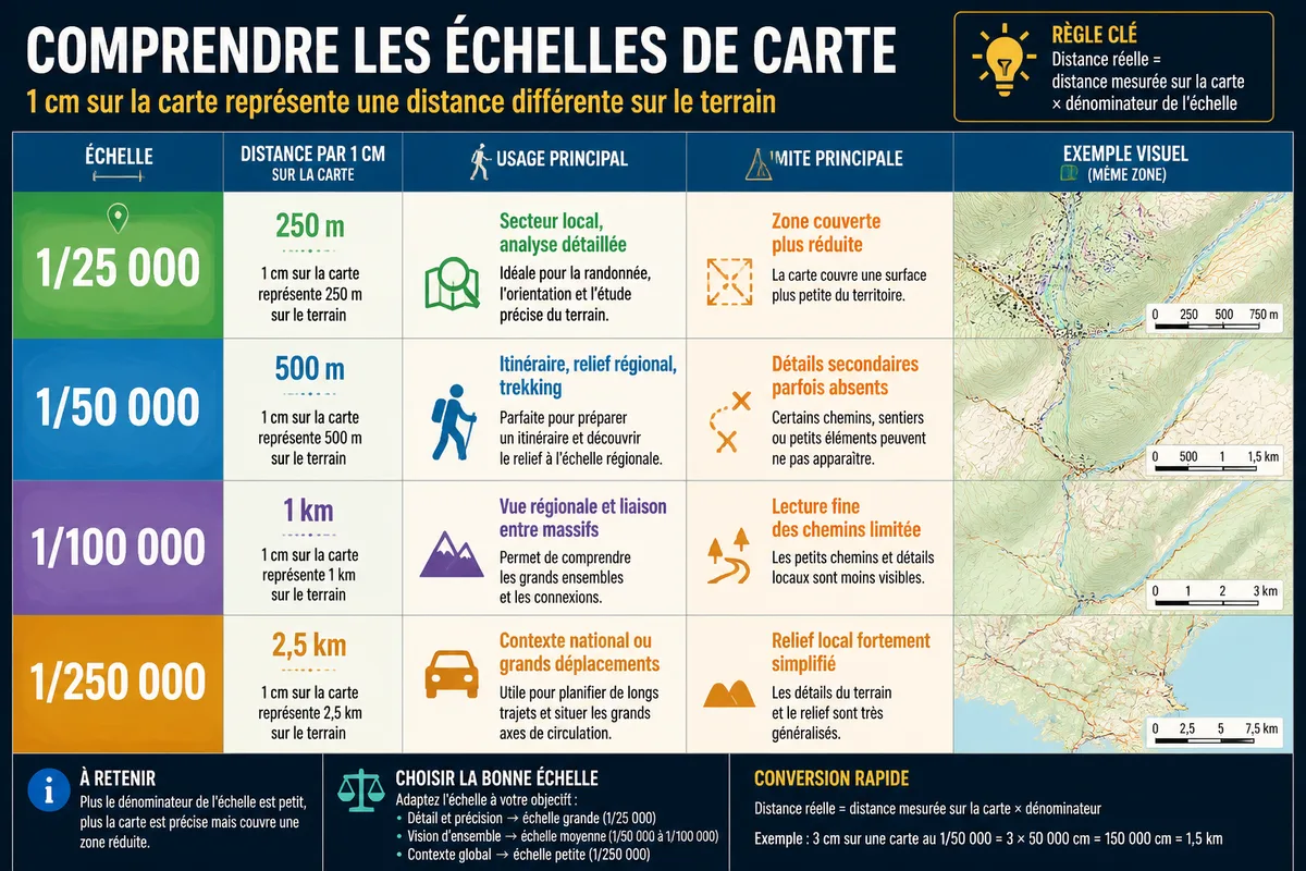
1/25,000 offers the finest level of detail among the three official series mentioned, 1/50,000 is a practical compromise, and 1/100,000 covers a larger area. The right choice therefore depends on the precision sought, the size of the sector, and the intended use.
1/25,000: local detail and fine reading
⏱ Practical advice: Take the time to study the legend of hypsometric tints (color shades according to altitude) before each hike or road trip to immediately identify slope break zones.
At this scale, 1 cm on the map represents 250 m on the ground. Paths, constructions, ravines, visible plots in the source, and slope changes can be distinguished more finely, if the sheet and its legend actually map them.
This series is suitable for studying a limited sector, local development, or meticulous route preparation. It quickly becomes cumbersome when covering a long crossing of the Atlas.
1/50,000: the compromise for a route
At 1/50,000, 1 cm represents 500 m on the ground. The sheet covers more terrain while maintaining a useful reading of valleys, ridges, roads, and main paths when they are reported.
For a multi-day prepared hike, this scale is often the most balanced. It provides enough context to understand the sequence of reliefs, without reducing a mountain range to a simple colored spot.
A guide published in June 2017 associated maps at 1/50,000, 1/100,000, 1/125,000, and 1/250,000 scales with uses such as trekking, guiding, 4×4, and motorcycling. This selection is outdated: it can serve as a historical indication, not a guarantee of the current availability of the files.
1/100,000 and smaller scales
At 1/100,000, 1 cm represents 1 km on the ground. This view is suitable for understanding a region, locating a general route, or comparing several mountain ranges, with less detail for secondary trails.

The 1/125,000 and 1/250,000 scales appear in some older or commercial selections. They are useful for gaining geographical overview, never to automatically replace a detailed sheet when passing through mountains.
| Scale | Distance represented by 1 cm | Relevant use | Limit |
|---|---|---|---|
| 1/25,000 | 250 m | Local area, detailed analysis | Smaller covered area |
| 1/50,000 | 500 m | Route, regional relief, trekking | Secondary details sometimes missing |
| 1/100,000 | 1 km | Regional view and connection between massifs | Fine reading of paths limited |
| 1/250,000 | 2.5 km | National context or long-distance travel | Local relief heavily simplified |
What do contour lines and altitudes show?
A topographic map translates a surface into two dimensions. Contour lines connect points at the same altitude: when close together, they indicate a steep slope; when spaced apart, they indicate a gentler slope, provided the contour interval announced in the legend is known.

derivative work: Inkey / Wikimedia Commons
A single contour line is never enough to measure the difficulty of a route. One must observe its spacing, orientation, the valleys crossed, and any terrain breaks.
In the High Atlas, the map shows the gradual elevation of the valleys towards the ridges, then the sharper break of the slopes. Jbel Toubkal reaches 4,167 m according to the Encyclopaedia Britannica, but this maximum altitude alone does not provide information about the elevation difference from a specific starting point.
Legend, hydrography and toponymy
The legend explains the symbols used for roads, tracks, buildings, watercourses, springs, vegetation, boundaries, and elevation points. A local toponym may designate a mountain, a douar, or a pass without indicating difficulty of access.
Watercourses are particularly useful for understanding the structure of a relief. They often follow the valley bottoms, while the ridgelines separate the watersheds.
However, a topographic map does not guarantee that a depicted trail is maintained, open, or passable on the day of departure. Weather, floods, works, and local restrictions change the reality observed on site.
Relief, road map and urban plan
A road map prioritizes connections and distances between cities. An altitude map colors or shades the relief for immediate reading. An urban topographic plan zooms in more on a city: the ANCFCC defines it as a large-scale representation, at 1/20,000 and above.
To prepare a trip, tourist maps of Morocco are better suited for stages, sites, and main accesses. They complement a topographic map without replacing it when it is necessary to read a slope or a ridgeline.
How to download and use a sheet by region?
Start by naming the area, then choose the scale, identify the sheet, and check its format. On a computer, check the legend and coordinates before exporting; on mobile, keep an offline version, as the interactive map will not always be accessible in a valley or desert area.
- Define the area. Note the region, the nearest city, and the relevant reliefs.
- Choose the scale. Take 1/25,000 for a specific sector, 1/50,000 for an itinerary, 1/100,000 for a regional view.
- Compare the source. Distinguish an ANCFCC sheet, a third-party catalog, a digitized archive, and an interactive map.
- Check the file. Verify the edition, the legend, north, coordinates, and reuse rights.
- Prepare for offline use. Download the sheet and test its opening before leaving.
Sheet numbers can help assemble neighboring maps. Indexes published for the 1/100,000 series notably associate Tangier with sheet 1, Chefchaouen with 4, Oujda with 16, Fès with 16 ter, Marrakech with sheets 98 and 99, Tineghir with 103, and Errachidia with 106.
For the 1/50,000 series, published references associate Tangier with sheet 1, Tétouan with 6, Chefchaouen with 18, and Oujda with 60. In the Southwest, Ouarzazate appears under number 343, Taliouine under 354, Agdz under 359, and Agadir under 360.
These numbers facilitate continuity between sheets, without constituting by themselves proof of availability or recent edition. A third-party index may reuse an old nomenclature, an incomplete series, or references whose file is no longer accessible.
Formats and compatibility with GPS
A raster file is an image composed of pixels. A vector file retains separate objects, such as lines, points, or polygons, which facilitates certain scaling changes in GIS software.
A JPG alone is not necessarily georeferenced. It can correctly display relief while remaining unusable for automatically positioning a GPS track, unless accompanied by a calibration file or associated coordinates.
Before importing a map into a GPS or GIS software, check the projection, datum, coordinate format, and unit used. A difference in reference system can create a shift between the track, the road, and the relief, even if the image appears visually accurate.
The guide on the vector map of Morocco can help understand this difference between a cartographic image and usable data. For a professional analysis, it is impossible to decide here without knowing the exact file: its metadata determines the quality of positioning.
What to check before a hike
Digitized historical maps have real value for comparing the evolution of roads, names, or land use. They should not be used as a current base without verification, especially when a track, an administrative boundary, or a recent construction conditions the route.

Paper maps sold by an organization or reseller require the same caution regarding stock, price, order, and delivery. This information varies according to the distributor and cannot be confirmed here without a current commercial sheet; check them directly before payment.
What do closely spaced contour lines on a map of Morocco mean?
Very tight contour lines indicate a steep slope or a cliff, common in high mountain areas such as the Atlas or the Rif.
What is the use of a topographic map compared to a standard GPS?
The topographic map offers a global view of relief, elevation changes, and terrain morphology, which a GPS screen often hides by focusing only on the immediate route.
How to find information about the altitudes of Moroccan mountain passes?
Specialized topographic maps precisely indicate the numeric altitude of passes (such as Tizi n’Tichka), allowing anticipation of weather and driving conditions.
.magic-lb-overlay.open{display:flex}
.magic-lb-overlay img{max-width:95vw;max-height:95vh;object-fit:contain;border-radius:8px;box-shadow:0 8px 32px rgba(0,0,0,.5)}
.magic-lb-close{position:absolute;top:16px;right:20px;color:#fff;background:rgba(0,0,0,.5);border:none;width:40px;height:40px;border-radius:50%;font-size:24px;cursor:pointer;display:flex;align-items:center;justify-content:center}
.magic-lb-close:hover{background:rgba(0,0,0,.8)}
.wp-block-image img{cursor:zoom-in;transition:transform .15s ease}
.wp-block-image img:hover{transform:scale(1.01)}
.magic-img-link{display:inline-block;text-decoration:none}
(function(){
var ov=document.getElementById(‘magic-lb’);if(!ov)return;
var img=ov.querySelector(‘img’),btn=ov.querySelector(‘.magic-lb-close’);
var L={fr:’Fermer’,es:’Cerrar’,en:’Close’,pt:’Fechar’,it:’Chiudi’,de:’Schlie\u00dfen’,nl:’Sluiten’,ca:’Tancar’};
btn.setAttribute(‘aria-label’,L[(document.documentElement.lang||”).slice(0,2).toLowerCase()]||’Close’);
function open(src){img.src=src;ov.classList.add(‘open’);document.body.style.overflow=’hidden’}
function close(){ov.classList.remove(‘open’);img.src=”;document.body.style.overflow=”}
document.addEventListener(‘click’,function(e){
var a=e.target.closest(‘a.magic-img-link’);
if(a){e.preventDefault();open(a.getAttribute(‘href’));return}
var i=e.target.closest(‘.wp-block-image img’);
if(i&&!e.target.closest(‘a’)){e.preventDefault();open(i.currentSrc||i.src)}
});
ov.addEventListener(‘click’,function(e){if(e.target===ov||e.target===btn)close()});
document.addEventListener(‘keydown’,function(e){if(e.key===’Escape’)close()});
})();