
What You Need to Know About Burkina Faso
The State of Burkina Faso is a Constitutional republic located in Africa. The area of Burkinabe territory is 274,400 km2 and its population is 20,835,401 inhabitants, which translates to a density of 76 inhabitants per km2.
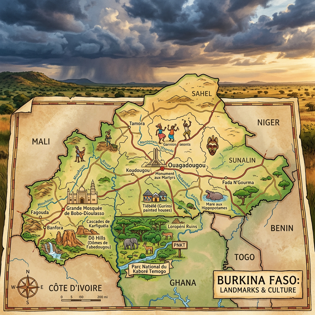
The capital of the country and its largest city is Ouagadougou and the official language of the country is French. The country’s telephone code is 226, either 00226 or +226.
Table – Burkina Faso: Geographic and Demographic Information
| Item | Key Information |
|---|---|
| Total Area | 272,967 km² |
| Capital | Ouagadougou |
| Neighboring Countries | Mali, Niger, Benin, Togo, Ghana, Ivory Coast |
| Coastline | None (landlocked country) |
| Estimated Population | ~24 million inhabitants (2025) |
| Population Density | ~88 inhabitants/km² |
| Relief | Plateaus, savannas, some hills |
| Climate | Sudano-Sahelian tropical, alternating dry season / rainy season |
| Official Language | French |
| Economic Resources | Gold (1st export product), cotton, subsistence agriculture |
| Particularity | Sahelian country without access to the sea, heavily agricultural |
Additional Points on the Map of Burkina Faso

- Burkina Faso is located in West Africa, at the heart of the Sahel region.
- Landlocked, it shares its borders with six states: Mali, Niger, Benin, Togo, Ghana, and Ivory Coast.
- Its physical map shows an essentially flat relief, with vast savannas.
- The capital Ouagadougou is also the country’s major cultural center, notably with FESPACO (Pan-African Film Festival).
- The economy mainly relies on gold and cotton, but subsistence agriculture remains essential.
Colors of Burkina Faso
The flag of Burkina Faso is a two-color flag arranged in horizontal bands with red on top and green below. In the middle of the flag is a yellow (gold) five-pointed star.
The red symbolizes the arid plateaus of the northern part of the country. The star and the gold symbolize the light that guides the people or the capital. The green symbolizes fertility and the green color of the land.

Main Cities and Best Places to Visit in Burkina Faso ?
Ouagadougou: The capital of Burkina Faso is also the economic and administrative cradle of the country. You will see a Roman Catholic cathedral there and also attend several shows (music, various festivals…). Also visit the craft markets to buy local products.
Bobo-Duoulasso: It is the second largest urban area in the country. It is very lively especially at night and will allow you to attend random festivities in the city’s bars and clubs.
It is a place of relaxation for backpackers and at the same time a welcoming city.
Banfora: It is a very beautiful city appreciated by tourists. You will find the Tengrela lake there, which is a place where you can observe hippos and have a picnic.
There are also guesthouses for various holidaymakers, as well as waterfalls :
1. Karfiguéla Waterfalls
These are the most famous waterfalls in the country.
They are formed by a series of small cascades along the Comoé River.
The administrative region known as the Cascades Region actually takes its name from this site.
Visitors can swim in some of the natural pools found there.
The best time to visit is during the rainy season, from June to September, when the water flow is at its most spectacular.
2. The Small Waterfalls Around Banfora
Around Banfora, there are also a few lesser-known waterfalls and seasonal streams that appear mainly during the rainy season. They attract mostly local residents and travelers seeking to experience the region’s natural beauty.
3. The Natural Attractions of the Cascades Region
Many visitors combine a trip to the waterfalls with visits to the Fabédougou Domes and Lake Tengrela, which is famous for its hippopotamuses. This region is considered the main ecotourism destination in Burkina Faso.
In fact, unlike some other West African countries, Burkina Faso does not have a large number of spectacular waterfalls. The Karfiguéla Waterfalls therefore remain a must-see destination for nature lovers and are among the most visited tourist sites in the country.
Where is Burkina Faso located on the world map?
Burkina Faso is a landlocked country on the African continent. The state of Burkina Faso is located in West Africa. Its neighboring countries are Mali, Niger, Ivory Coast, Ghana, Togo and Benin. Mali borders it to the northwest, Niger to the northwest, the other countries are located to the south.

Climate of Burkina Faso
The climate of Burkina Faso is tropical. It is characterized by inconsistent rainfall throughout the year varying from north to south between 350 mm and 1000 mm. The dominant seasons are: the rainy season and the hot season varying to dry which experiences the breath of the Harmattan coming from the Sahara.
Here are the climatic subdivisions of the Burkinabe territory: the Sahelian zone, the Sudanese-Sahelian zone, the Sudanese-Guinean zone. The seasons are generally divided into two, namely a cold season between June and September and a summer season between October and June. Temperatures throughout the year range between 16 and 45°C and rains occur evenly throughout the year.
Administrative Division of Burkina Faso
The territory of Burkina Faso is divided into 13 regions which are in turn divided into 45 provinces. The last level of subdivision is composed of 351 departments. Here are the 30 regions:

Political map of Burkina Faso

Relief map of Burkina Faso
- Boucle du Mouhoun
- Cascades
- Centre
- Centre-Est
- Centre-Nord
- Centre-Ouest
- Centre-Sud
- East
- Hauts-Bassins
- North
- Central Plateau
- Sahel
- South-West
Here are the 45 provinces of Burkina Faso
- Kadiogo
- Bam
- Namentenga
- Sanmatenga
- Bazèga
- Nahouri
- Zoundwéogo
- Ganzourgou
- Kourwéogo
- Oubritenga
- Boulgou
- Koulpélogo
- Kouritenga
- Gnagna
- Gourma
- Komondjari
- Kompienga
- Tapoa
- Loroum
- Passoré
- Yatenga
- Zondoma
- Oudalan
- Séno
- Soum
- Yagha
- Houet
- Kénédougou
- Tuy
- Bougouriba
- Ioba
- Noumbiel
- Poni
- Balé
- Banwa
- Kossi
- Mouhoun
- Nayala
- Sourou
- Comoé
- Léraba
- Boulkiemdé
- Sanguié
- Sissili
- Ziro
Economy of Burkina Faso
Burkina Faso is one of the least developed countries in the world. Its economy has always been less developed but currently its economic growth has increased relatively by 6.51%. The reasons for these economic instabilities are the lack of infrastructure, less efficient industries, and the active population which is only 14%. Agriculture is predominant with 86% of the population being farmers. Here are some data:

- Official currency: CFA franc
- Nominal GDP: 11.97 billion USD
- GDP at purchasing power parity (PPP): 34.9 billion USD
- GDP growth rate: 8.5%
- GDP per capita in PPP: 1,600 USD
- Inflation rate: 8.1%
- Population below the poverty line: 50%
- Unemployment rate: 45% of the active population
The economy of Burkina Faso is mainly based on subsistence agriculture, gold (the primary export resource), and cotton. The country is still heavily dependent on its mining and agricultural exports, although efforts to diversify have begun.
Population of Burkina Faso
The population of Burkina Faso is estimated at 21,510,181 inhabitants with a high population growth rate of 3.07% per year. The average life expectancy is 61.2 years.
The birth rate is 40.0 ‰ while the mortality rate stands at 9.6 ‰. The fertility rate remains high with 5.52 children per woman, reflecting a very young population.
FAQ – Burkina Faso map
Burkina Faso is in West Africa, landlocked between six countries: Mali, Niger, Benin, Togo, Ghana, and Ivory Coast.
The capital is Ouagadougou, the administrative and cultural center of the country.
It is a Sahelian country of plateaus and savannas, without a coastline, characterized by an alternation between dry season and rainy season.
