With a land area of only 181 square kilometers for nearly two million square kilometers of ocean, the Republic of the Marshall Islands holds the world record for the highest proportion of water relative to land. It is easy to get lost in the vastness of Micronesia without precisely locating these fragile coral atolls.
This article details the Marshall Island location within the Ratak and Ralik chains to help you situate this territory between sovereignty and American influence. Let’s review together the geography and challenges of this Central Pacific archipelago.
- Precise location of the Marshall Islands in the heart of the Pacific
- A hybrid political status between sovereignty and American influence
- 2 major challenges between nuclear legacy and climate emergency
- Practical guide for immersion in Marshallese culture
Precise location of the Marshall Islands in the heart of the Pacific
The Republic of the Marshall Islands, located in Micronesia between Hawaii and Australia, comprises 29 coral atolls and 5 islands. This sovereign archipelago of the central Pacific Ocean is organized around the Ratak and Ralik chains.
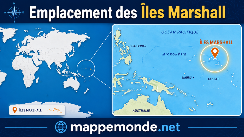
To understand the organization of this territory, one must first look at its position within the vast Micronesian region.
To explore more island destinations, check out luxury ocean cruise routes for remote travel ideas. Understanding global country geographic profiles helps clarify Pacific microstate boundaries. You can also read tips on booking travel accommodations for island stays.
An isolated archipelago in Micronesia
The archipelago is located east of the Caroline Islands and north of Kiribati. Its exclusive economic zone is immense, covering nearly two million square kilometers of the Pacific Ocean.
The coordinates are approximately 7° North and 171° East. This isolation is total, lost in the deep waters of the North Pacific, far from any continental landmass.
The emerged lands are tiny. They are scattered over an absolutely colossal oceanic surface.
The Ratak and Ralik Chains
Ratak means “sunrise” to the east and Ralik “sunset” to the west. These two parallel alignments of atolls structure the entire national territory of the Marshalls. They are the backbone of the country.
Ratak: “sunrise”, chain located to the east.
Ralik: “sunset”, chain located to the west.
The 29 atolls are distributed between these two major axes. Each chain has its own climatic characteristics. Their specific lagoons also mark the difference between the eastern and western Marshalls.
Majuro and the Structure of the Atolls
Majuro, the capital, resembles a narrow strip of land. It encloses a huge lagoon and constitutes the nerve center of the country.
These coral atolls formed on ancient submerged volcanoes. The average altitude is negligible. It rarely exceeds two meters above sea level.
The atolls of the Marshall Islands are fragile structures, simple coral rings resting on the abyss, where solid land seems almost an anomaly.
A Hybrid Political Status Between Sovereignty and American Influence
While geography imposes isolation, the political destiny of the Marshalls remains intimately linked to a distant power: the United States.
- Independence: 1986 (1990 UN)
- Population: ~38,827 inhabitants
- Territory: 30 atolls and 1,100 islands
How the Compact of Free Association Works
The Compact of Free Association (COFA) defines this unique link. The country is sovereign but delegates its defense to American forces. This cooperation guarantees the protection of the archipelago.
Marshallese people travel and work freely in the United States without a visa. Washington provides massive financial aid in exchange for this military control. It is the driving force of the local economy.
- Independence obtained in 1986
- Official currency: US Dollar
- Defense responsibility: Pentagon
- Voting rights at the UN: sovereign
The strategic role of the Kwajalein base
The Kwajalein atoll constitutes a major strategic site. It houses the Reagan Test Site for missile launches. This facility is vital for American defense.
The base is the largest local employer after the government. It creates a strong dependency for neighboring populations such as Ebeye. The economic impact is omnipresent there.
Yet, the tension between national sovereignty and military presence persists. This complex balance defines the current local political life. The Marshall Islands location remains a hot geopolitical issue.
2 major challenges between nuclear legacy and climate emergency
This relationship with the United States nevertheless carries the weight of a painful past that resonates with current environmental threats.
The rising sea level and cracks in the Runit dome threaten the integrity of the archipelago.
The scars of the Bikini and Enewetak tests
The United States conducted 67 nuclear tests between 1946 and 1958. The Castle Bravo explosion, a thousand times more powerful than Hiroshima, devastated Bikini and marked history forever.
The Runit dome on Enewetak atoll crystallizes fears. This concrete sarcophagus stores radioactive waste. Cracks are appearing due to coastal erosion and aging.
The health consequences remain tragic for displaced families. Cancers and malformations are persistent realities. These sufferings still deeply mark Marshallese society today.
The fight against rising sea levels
Erosion is nibbling away at gardens and homes. Rising waters directly threaten the physical existence of the country. For these low-lying atolls, the peril is now immediate.
Salinization of groundwater makes traditional agriculture impossible. Seawater infiltration contaminates vital freshwater reserves. This situation forces inhabitants to rethink their survival.
The government is multiplying initiatives, such as building dikes. The Marshallese refuse to become climate refugees. They are waging an intense diplomatic fight to save their land.
Practical guide for an immersion in Marshallese culture
Despite these trials, the archipelago remains a land of living traditions and a timeless destination for discerning travelers.
Air access and stay formalities
The adventure begins with the legendary United Airlines “Island Hopper.” This route connects Guam to Honolulu by flying over the vast blue expanse. The plane stops at several isolated atolls in the country.
On the administrative side, most travelers obtain a visa on arrival. Plan your usual vaccinations before departure. Strict mosquito protection is essential on site.
| Practical element | Detail | Advice |
|---|---|---|
| Currency | US Dollar | Bring cash |
| Language | Marshallese/English | English is sufficient everywhere |
| Electricity | 110V (US type) | Bring an adapter |
| Time zone | UTC+12 | Watch out for the time difference |
Maritime economy and local traditions
The local economy relies on tuna fishing and flags of convenience. These sectors support national finances. However, American aid remains a major budgetary pillar.
Craftsmanship shines through the delicate weaving of pandanus leaves. The famous “stick charts still fascinate visitors.” These ancestral maps use sticks to read the ocean.
Stick charts are unique tools mapping currents and swells using shells.
Traditional navigation in the Marshall Islands is not just a technique; it is a sacred bond between man, the stars, and the invisible currents of the Pacific Ocean.
Located in Micronesia, this coral archipelago is organized around the Ratak and Ralik chains. To fully understand the Marshall Island location, remember its sovereignty linked to the United States and its climate vulnerability. Explore these unique atolls now before rising waters radically transform this Pacific gem.
Pacific ocean transit time calculator
Estimate maritime travel time to Majuro Atoll based on distance and speed
FAQ
Where exactly are the Marshall Islands located on a map?
The Republic of the Marshall Islands is located in the heart of Micronesia, in the southwestern part of the North Pacific Ocean. This sovereign archipelago lies east of the Caroline Islands and north-northwest of the Gilbert Islands, spanning a vast maritime area between Hawaii and Australia.
How many islands and atolls make up this archipelago?
The state consists of 30 coral atolls and about 1,100 islands and islets. These land formations are organized into two distinct parallel chains: the Ratak chain (sunrise) to the east and the Ralik chain (sunset) to the west.
What is the capital of the Marshall Islands and where is it located?
The capital is Delap-Uliga-Darrit, located on the Majuro atoll. This nerve center houses a very large portion of the country’s total population, estimated at about 38,827 inhabitants in 2023.
What is the political status of the Marshall Islands in relation to the United States?
The Marshall Islands are a sovereign republic linked to the United States by a Compact of Free Association (COFA). In exchange for financial aid and residency rights for its citizens, the country delegates its international defense to the Pentagon, having no standing army of its own.
What are the main environmental threats to the archipelago?
Due to their low elevation, the islands are extremely vulnerable to climate change, particularly sea level rise and coastal erosion. The country must also manage the aftermath of 67 U.S. nuclear tests, such as the radioactive containment dome at Runit on Enewetak Atoll.
What languages are spoken in the Marshall Islands?
Marshallese is the official language of the archipelago, with two main dialects corresponding to the Ratak and Ralik chains. English is however widely spoken and remains the preferred language for administration and international exchanges.
What logistical advice is there for a traveler going there?
The official currency is the U.S. dollar and electricity uses US-type plugs (110V). To reach the archipelago, the most famous way is the “United Airlines ‘Island Hopper’“, which connects Guam to Honolulu with stops on several Marshallese atolls.