
What you need to know about the Comoros ?
The Comoros form an island state in East Africa, officially called the Union of the Comoros. It is a federal republic with a semi-presidential system, equipped with parliamentary institutions.
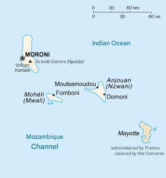
The archipelago is made up of four main islands: Grande Comore (Ngazidja), Mohéli (Mwali), Anjouan (Ndzuwani), and Mayotte (Maore), the latter still administered by France but claimed by the Union of the Comoros.
- The total area of the Comorian territory is 2,612 km².
- The population is estimated at about 870,000 inhabitants in 2025.
- The capital and largest city is Moroni, located on the island of Grande Comore.
The Union of the Comoros is a member of the UN, the Organization of Islamic Cooperation (OIC), and COMESA.
The international telephone code is +269.
Table – Comoros: geographic and demographic information
| Element | Key Information |
|---|---|
| Total area | 2,235 km² |
| Capital | Moroni |
| Neighboring countries | None (Island state), near Madagascar and Mozambique |
| Archipelago | Grande Comore, Mohéli, Anjouan (+ Mayotte administered by France) |
| Estimated population | ~900,000 inhabitants (2025) |
| Population density | ~400 inhabitants/km² |
| Relief | Volcanic islands (Karthala, active volcano on Grande Comore) |
| Climate | Tropical maritime, hot and humid |
| Official languages | Comorian, Arabic, French |
| Economic resources | Agriculture (vanilla, clove, ylang-ylang), fishing |
| Particularity | Indian Ocean archipelago, located between Africa and Madagascar |

Additional points on the map of the Comoros
- The Comoros are located in the Mozambique Channel, between the East African coast and Madagascar.
- The archipelago is composed of three main islands: Grande Comore, Anjouan, and Mohéli.
- The Karthala volcano is one of the most active in the world.
- The capital Moroni is located on Grande Comore.
- The economy mainly relies on agriculture and the Comorian diaspora.
Colors of the Comoros
The Comorian flag is a rectangular flag with 4 horizontal colored stripes. From top to bottom: Yellow, white, red, blue. The left side of the flag is topped by a green equilateral triangle with a crescent moon and 4 five-pointed stars.

Best places to visit in the Comoros ?
Mohéli: It is a small, sparsely populated town. You will see the only park in the Comoros called Mohéli Park. Tourists can also enjoy the waterfront where you can relax on the beaches to observe dolphins, sea turtles, and other marine species.
Fomboni: It is the largest city in the country but also a quiet place for tourists. You will find a charming town with spacious streets, a friendly market, and the pier to enjoy the sea view.
Anjouan: It is also nicknamed the “pearl of the Comoros,” it is a town both isolated and touristic. Marked by several plantations of clove and ylang-ylang trees, it is worth a visit so you can see the locals at work on processing and crafts.
Where is Comoros located on the world map?
On the world map, the Comoros form an African state located in Africa in the Southern region. In fact, it is a country located north of the Mozambique Channel. The countries closest to the Comoros are Madagascar, Mayotte (French overseas department), and Mozambique.
Composed of the islands Grande Comore, Mohéli, and Anjouan, the country is marked by its volcanism and agricultural products such as ylang-ylang and vanilla.

Climate of the Comoros
The climate of the Comoros is tropical maritime. There are several random variations in daytime temperatures which range between 25 and 26°C. Moreover, the average annual precipitation is around 2,600 mm. The country’s climate is divided into two:
The dry season occurs between May and October and is subject to an anticyclone which can cause some gusts of wind.
The hot and humid season takes place between April and October. However, the climate is warmer in Mayotte throughout the year compared to the other islands.
Administrative division of the Comoros
The Comorian territory is divided into 3 autonomous islands which are made up of 16 prefectures, which in turn are divided into 54 municipalities. Here are the autonomous islands and their prefectures:
Grande Comore (Ngazidja)
- Moroni-Bambao
- Hambou
- Mbadjini-West
- Mbadjini-East
- Oichili-Dimani
- Hamahamet-Mboinkou
- Mitsamiouli-Mboudé
- Itsandra-Hamanvou,
Anjouan (Ndzwani)
- Mutsamudu
- Ouani
- Domoni
- Mrémani
- Sima
Mohéli (Mwali)
- Fomboni
- Nioumachoi
- Djando
Economy of the Comoros

The Comoros are considered a low-income developing country, ranked among the poorest nations in the world. The economy is mainly based on subsistence agriculture and fishing, while a large part of the population lives in rural areas.
The main exports are:
- vanilla,
- ylang-ylang (whose essence is used by major perfume houses like Guerlain),
- clove.
These products represent an essential part of foreign currency earnings, but the economy remains fragile and heavily dependent on external aid and remittances from the diaspora.
Key Economic Data (2025)
- Currency: Comorian franc (KMF)
- Nominal GDP: ~1.39 billion USD
- GDP (PPP): ~3.3 billion USD
- Annual GDP growth: ~3%
- GDP per capita (nominal): ~1,500 USD
- GDP per capita (PPP): ~3,700 USD
- Inflation: ~4%
- Population below poverty line: ~40%
- Human Development Index (HDI): ~0.55 (low ranking, but progressively improving)
Population and linguistic data of the Comoros
The population of the Comoros is estimated at about 870,000 inhabitants in 2025, with a population growth rate of about 2% per year.
- Fertility rate: ~3.9 children per woman
- Birth rate: ~27 ‰
- Mortality rate: ~6 ‰
- Life expectancy: ~64 years (62 years for men, 66 years for women)
- Median age: ~20 years (very young population)
- Sex ratio: ~96 men per 100 women
Main ethnic groups
- Grand-Comorians (Ngazidja)
- Anjouanese (Ndzuwani)
- Mohélians (Mwali)
- Sabénas (minority of Arab-Shirazi origin)
Religions
- Sunni Islam (Shafi’i) : ~99 %
- Christianity (Catholicism, Protestantism) : <1 %, mainly practiced by expatriates
Languages
Other languages : Malagasy and English (increasing in business and tourism)
Official languages : Arabic and French
National language : Comorian (Shikomori), a Bantu language close to Swahili
FAQ – Comoros map: 3 questions
The Comoros are located in the Indian Ocean, between Madagascar and Mozambique.
The capital is Moroni, on the island of Grande Comore.
A volcanic archipelago, they have mountainous terrain, a tropical climate, and rich biodiversity.
