
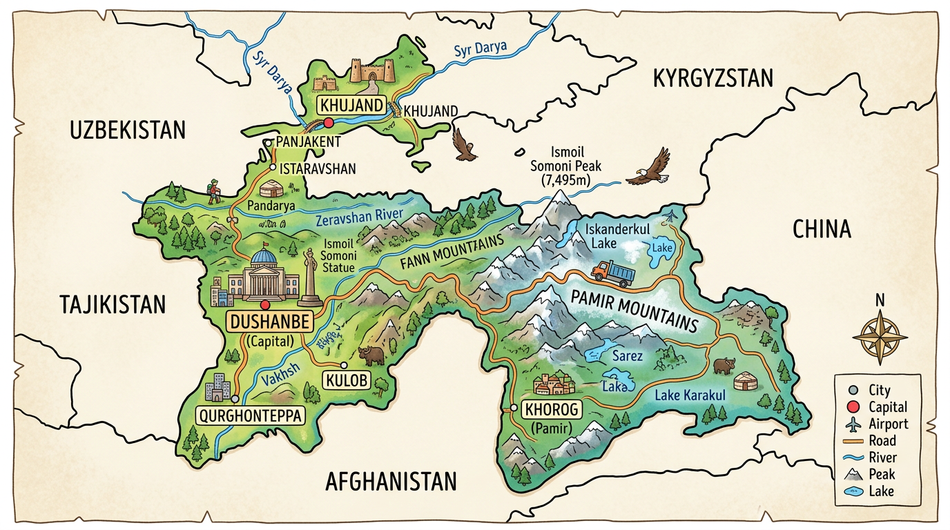
When mentioning Tajikistan, few people immediately locate this country on a map. Yet, this mountainous republic is full of impressive landscapes and fascinating stories. The geography of Tajikistan shapes its identity: omnipresent mountains, lush valleys, and winding rivers intertwine over thousands of square kilometers. To better understand this little-known country, nothing beats exploring a map of Tajikistan. Following its roads, identifying the cities and capitals, spotting the major waterways… each map offers a new perspective on this state clinging to its reliefs, far from maritime coasts. Discovering this territory often begins by lingering over its road or tourist map to grasp all its nuances.
Why take an interest in the map of Tajikistan?
Far from being just a simple piece of paper or a virtual image, the map of Tajikistan reveals many essential pieces of information for all those who wish to explore, study, or dream about this country. Given its landlocked nature, it quickly becomes indispensable for visualizing access from neighboring nations and for understanding the internal organization of the territory.
It also constitutes a remarkable educational tool. Nature lovers, geography enthusiasts, or future travelers immediately find the Tajik specificity: a mountainous country, surrounded by powerful ranges that make up more than 90% of its area.
The main geographical features of Tajikistan
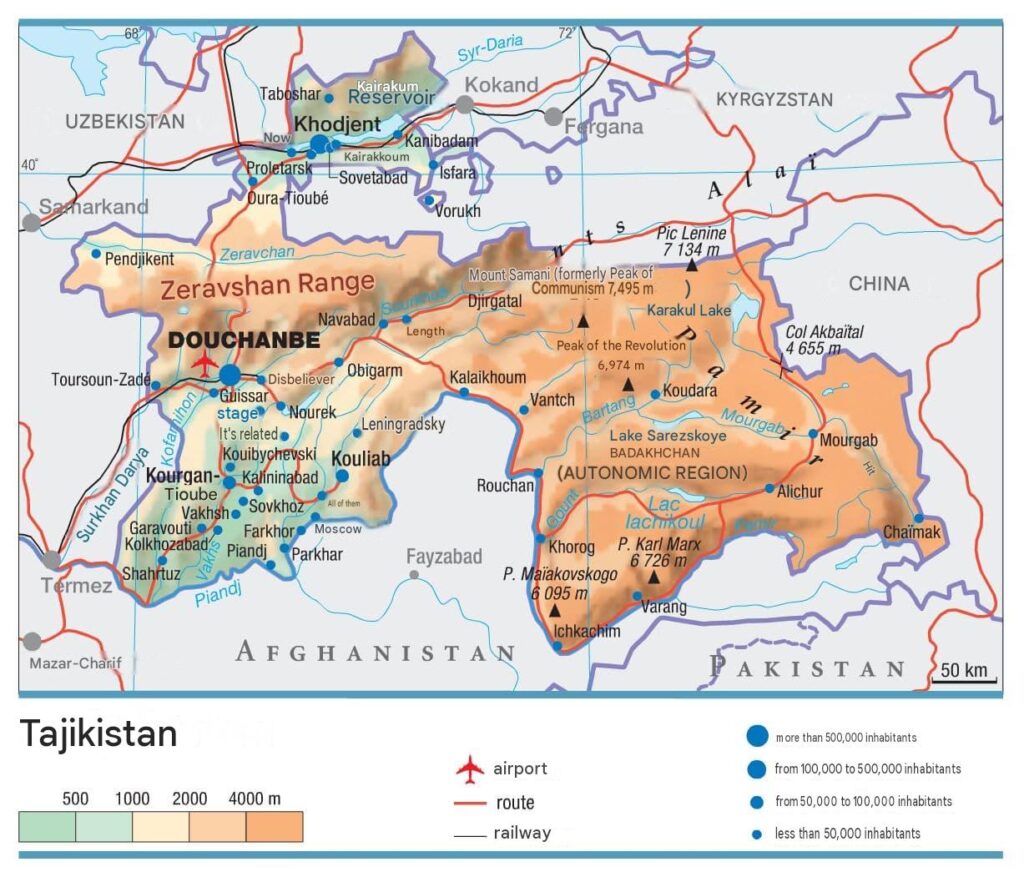
The relief of Tajikistan stands out very clearly from that of other Central Asian countries. The Pamir Mountains, considered the roof of the world, dominate the eastern half of the territory while agricultural valleys stretch to the north and west.
Finding these contrasts on a map helps better understand the historical, economic, and human issues specific to this nation. Between steep peaks, fertile basins, and tumultuous rivers, the whole forms a mosaic of varied landscapes.
Mountains and vast massifs
It is impossible to talk about a map of Tajikistan without mentioning its mythical mountains. Near the border with China rises the Pamir range, nicknamed “the roof of the world.” There, several peaks rise above 7,000 meters, notably Ismoil Somoni Peak. Further west, the Alay range cuts across the northern tip of the country, marking a spectacular natural border.
This fragmentation of the relief makes any cartographic reading captivating to trace possible routes and imagine adventures within these fierce mountains. Between steep passes, perched plateaus, and narrow valleys, the topography fascinates both on the ground and through the simple observation of a map.
Rivers, streams, and water resources
Although Tajikistan is a landlocked country, it does not lack fresh water thanks to numerous rivers and streams. The most famous is the Amu Darya, forming the southwest border and largely contributing to the country’s agricultural fertility. Other important rivers, such as the Vakhsh or the Panj, wind through the valleys between the tortuous mountains.
Locating these watercourses on a map immediately reflects the hydrological wealth of the territory. These elements structure local life: agricultural exploitation, villages settled along the banks, road axes following the sinuosity of certain rivers. They therefore occupy a central place on any tourist map or detailed city plans.
Cities and capitals visible on the map of Tajikistan
It is difficult to travel through Tajikistan only via its reliefs without taking an interest in its urban centers. The main cities, well identified on the map, testify to the recent evolution of the country and its social dynamics.
The contrast between Dushanbe, a modern capital, and more modest localities such as Khujand or Kurgan-Tyube offers an interesting perspective, both on the ground and when looking at a detailed map.
Dushanbe, a capital between tradition and modernity
Dushanbe occupies a strategic position in the center-west of the country. On a road map, it clearly appears as an essential crossroads, connected to other major cities by the main routes. Its urban development goes hand in hand with its location, facilitating trade and internal exchanges.
This dynamic city concentrates institutions and cultural activities but retains a special atmosphere linked to its traditional origins. Locating its different neighborhoods on the city maps gives a precise idea of the capital’s diversity and helps organize any stay or business trip.
Other must-see cities
Khodjent, the country’s second city, attracts thanks to its location in the fertile Fergana valley. It represents the gateway to the agricultural and commercial north. The map of Tajikistan also highlights Kurgan-Tyube in the south, as well as Kulyab, the starting point for excursions to the Pamir.
These urban points form vital hubs along the main routes, giving the Tajik network its population balance despite the difficulty of building in mountainous terrain. A glance at the map allows efficient selection of stops and anticipation of distances sometimes underestimated due to elevation changes.
Reading and practical use of different maps
Several types of maps coexist, each serving a specific purpose. Knowing their particularities makes it easier to prepare a trip on site or simply study geography from home. Here are some essential types of resources to consult before any exploration of the country.
Knowing how to use a tourist map is perfect for plotting a sightseeing itinerary, while a road map makes the reality of travel between mountainous regions and plains much clearer.
- Topographic maps: ideal for hiking in the Pamir or discovering the landscapes in detail.
- Tourist maps: they highlight places of interest, discovery routes, and remarkable natural sites.
- Road maps and main routes: valuable for organizing long-distance trips or identifying international connections to Uzbekistan, Kyrgyzstan, or China.
- City plans: practical for quickly orienting oneself in Dushanbe or other major urban centers.
Each resource provides a complementary view of the territory. Combining several maps leads to a comprehensive understanding, whether preparing a backpack, estimating travel time, or simply locating the major migration routes between valleys.
Some combine road and geographical data: they highlight not only passable roads but also border crossings and protected natural areas, valuable allies for ecotourism and adventure enthusiasts.
Tajikistan: a historical crossroads and contemporary challenges visible on the map
The evolution of Tajikistan also shows in the way its maps have been redrawn over history. Divided between Persian, Russian, and Turkish influences, then an active member of the former Soviet Union, the country today displays an autonomous face but remains dependent on cross-border exchanges.
Following the old trade routes such as the Silk Road or observing the construction of modern infrastructures (roads, tunnels, dams) allows one to perceive the political and economic impact of choices made since the fall of the USSR. Visualizing these exchanges on a map adds depth to the experience by concretely illustrating regional interdependence.
A landlocked country with sensitive borders
The completely landlocked position of Tajikistan strongly influences its geopolitical strategy: no access to the sea, rugged borders with Kyrgyzstan, Uzbekistan, Afghanistan, and China. Border relations fluctuate between cooperation and tensions related to water, natural resources, or security issues.
Identifying border crossings and logistical corridors on a road map provides information about the country’s vulnerability, but also about its adaptability in the face of trade and migration imperatives. The analysis of main routes confirms how much the terrain imposes its law, conditioning exchanges and mobility according to the climate and available infrastructure.
Maps serving tourism and education
For visitors as well as residents, having a good tourist map of Tajikistan turns every trip into a planned adventure. Hiking trails, historical monuments, local markets, or views of the major rivers reveal their potential only when you know where to look.
In schools, wall maps, city plans, and interactive materials support the learning of local geography and raise awareness of regional diversity. Learning to read these documents familiarizes both young and old with the complex reality of a country that has managed to leverage its isolation to develop a rich and resilient culture.
Perspectives offered by reading a map of Tajikistan
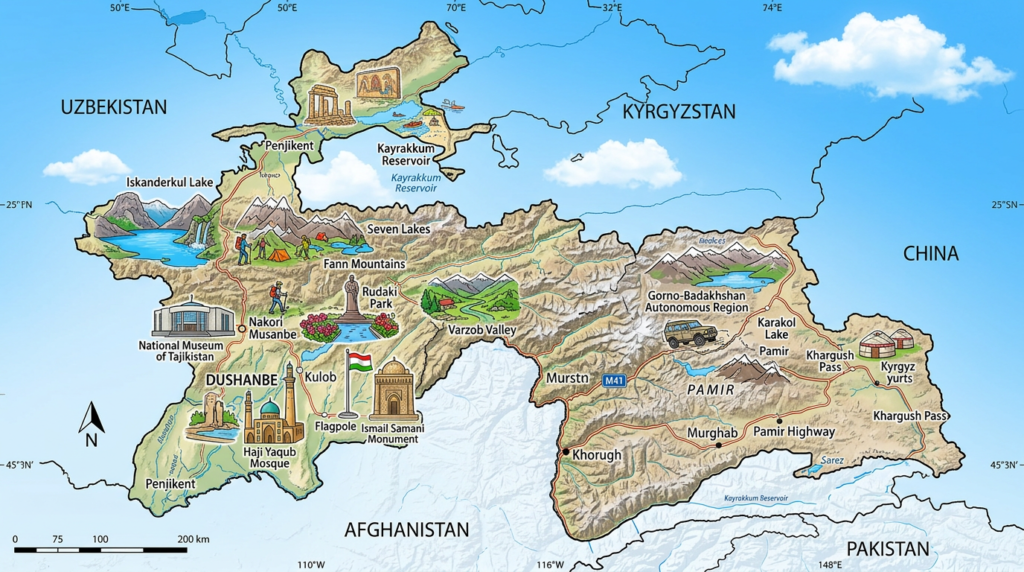
Observing Tajikistan on a map is opening a window onto distant horizons, confronting both the harshness of the terrain and the softness of scattered oases. The variety of available materials invites comparisons: each type of map targets a distinct audience, meets specific needs, and enriches our perception of this endearing country.
Navigating from a road map to city plans, moving from an overview to a detail of a river: these are all ways to travel, even in the mind, through this landlocked jewel of Central Asia. Even without having set foot on its soil, following these routes already makes one feel the breath of the peaks and the vigor of the valleys, like a first encounter to be continued in reality.
