
What you need to know about Belgium ?
Belgium is a European country located in the Northwest. Currently, it is one of the smallest countries in the world and also one of the countries with the highest population densities. Its capital is Brussels.
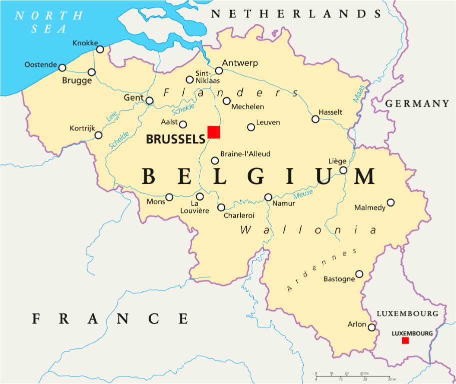
The borders Belgium shares with its neighbors total 860 miles or 1,385 km. To the North, it is bordered by the Netherlands, to the East by Germany, to the Southeast by Luxembourg, and to the South by France.
The area of Belgium is 30,527 km2 and it is also called the Belgian Federation. The federation is subdivided into three regions. These three regions are: the Walloon region, the Flemish region, and the Brussels region, which are subdivided into 10 provinces.
The provinces are made up of districts and municipalities. The telephone code for Belgium is 30, that is +30 or 0030.
The best cities in Belgium
Main attractions in Belgium
Brussels
Brussels is a city with a dual identity: the capital of Belgium and the political heart of the European Union. I spent two days there and came away with my head full! The Grand Place is simply one of the most beautiful squares in the world, the gilded facades of the guilds take your breath away, especially at night when everything is illuminated. Around it, the Royal Museums, the Magritte Museum, and the uniquely atmospheric bars of the Sablon district each deserve a stop. And of course, it’s impossible to leave without tasting the fries and waffles.
Bruges
Bruges felt like a journey back in time. The canals, the cobbled streets, the red brick facades… you understand why it’s called the “Venice of the North.” I wandered for hours without a specific goal, between cozy cafés and Gothic churches like the Basilica of the Holy Blood. It is one of the best-preserved medieval cities in Europe, and you feel it at every corner.
Antwerp
Antwerp is the surprise of the trip! The second largest city in the country, it combines historic elegance and contemporary energy like few other cities can. The diamond district, the world’s premier diamond market, sits alongside boutiques of international fashion designers. The central station, with its neo-baroque architecture worthy of a palace, is an attraction in itself. The Cathedral of Our Lady houses Rubens paintings that are worth seeing, and the nightlife is particularly lively.
Ghent
Ghent is my favorite city of the trip, yet it is often overlooked on classic tours! The medieval center is intact, the Castle of the Counts proudly overlooks the canals, and Saint Bavo’s Cathedral houses the famous polyptych of the Mystic Lamb by the Van Eyck brothers. The museums are excellent, the bars offer hundreds of different Belgian beers, and the atmosphere is both student-like and historic. Go there!
Leuven
Only 30 minutes from Brussels, Leuven is a city that lives to the rhythm of its university, one of the oldest and most prestigious in Europe, founded in 1425. The cobbled streets, the flamboyant Gothic Town Hall, and the Groot Begijnhof, a UNESCO-listed beguinage, give the city an authentic charm that the student flow makes lively and joyful. An ideal getaway for half a day.
Where are the cities located on the map?

Brussels:
Brussels is the capital and also a city located on the map in the center of Belgium. It is bordered by other municipalities of the Flemish region which make up the other 19 municipalities. Geographical location of Brussels: 50° 50′ north, 4° 21′ east
Bruges
Bruges is one of the major cities of Belgium. On the map, it is located in the province of West Flanders, which is in the Flemish region. It is also the largest city in its province. Geographical location: 51° 12′ North, 3° 13′ East
Antwerp
It is a city located on the map in the province of Antwerp in the middle of the country, also called the heart of the European backbone. The province is part of the Flemish region. Geographical location: 51° 13′ NORTH, 4° 24′ EAST.
Ghent
Ghent is on the map, a city located in the northwest of Belgium, between Bruges and Brussels. Its geographical coordinates are: 51° 3′ 0″ North, 3° 43′ 0″ East
Leuven
Leuven is a city located in the municipality of Ottignies Louvain La Neuve on the map. The municipality is part of the Walloon region which is part of the province of Walloon Brabant. Geographical location 50° 52′ 0″ North, 4° 42′ 0″ East
Belgium financial map
Belgium is a small open economy, strongly integrated into European and global trade. Despite its modest size, it represents 3.4% of the European Union’s GDP and stands out for a diversified industrial fabric and a highly developed service sector. The main challenge remains the public finances situation, with a high structural deficit that is subject to a European procedure.
The service sector is the engine of the economy, representing nearly 64% of the added value, followed by manufacturing industry (12.6%), dominated by chemicals, pharmaceuticals, and agri-food. Chemical and pharmaceutical products alone constitute a major share of Belgian exports, which are directed nearly two-thirds towards the European market.
| Indicator | Figure |
|---|---|
| Nominal GDP | 620 billion euros (2024) |
| GDP per capita | approximately 53,000 euros |
| GDP growth | +1.0% in 2025, +1.1% forecast in 2026 |
| Unemployment rate | 6.2% on average in 2025, slightly increasing |
| Inflation rate | 2.4% in 2025, returning to 1.4% in 2026 |
| Public deficit | approximately 5.1% of GDP in 2025 |
| Public debt | approximately 104% of GDP, progressively increasing |
| Currency | Euro |
Public debt, close to 104% of GDP, remains the main vulnerability point of the Belgian economy, fueled by structurally high social and health expenditures in a context of accelerated population aging.
Climate map of Belgium
The climate of Belgium is a temperate maritime climate. The reason is its proximity to the North Sea and the Atlantic Ocean. This climate is characterized by a cool summer and a mild winter. Climate variations are minimal because the country is small.

Belgium experiences uniform precipitation throughout the year. However, from April to September, the climate is drier. It also experiences strong depressions and violent winds in autumn that can be uncomfortable. In the East of Belgium, the climate is cool and humid with heavy precipitation and significant snowfall in winter.
Some specific climates:
Ostend
In Ostend, the climate is marked by a cool and cloudy spring and autumn. During the months of March and April, maximum temperatures are around 10°C because it is still cold. It is autumn that is rainy and not spring, and it is also the driest season of the year.
Brussels
In the capital, there is 850 mm of rainfall per year with rare sunshine from November to February. Moreover, summer is also weakly sunny, about 6 hours per day. During the months from January to July and August, temperatures vary between 18.5°C and 2.5°C.
Ardennes
The Ardennes experience abundant precipitation in winter and fairly low temperatures throughout the year. Winter is colder than in other cities and includes snow. Temperatures vary between 0.5°C and 16.5°C from January to July. Rainfall levels average 1,025 mm per year.
Demographic and administrative map of Belgium
Belgium has 11.8 million inhabitants as of January 1, 2025, representing about 0.14% of the world population, ranking it 83rd worldwide by population. The demographic growth is +0.52% per year, driven exclusively by a positive migration balance (+66,000 in 2024), as the natural balance is now negative, with deaths exceeding births structurally for the first time.
With an area of 30,280 km², Belgium is one of the most densely populated countries in Europe, with 389 inhabitants/km². The population is predominantly urban: nearly 99% of inhabitants live in urban areas, reflecting a very densely networked territory.
- Median age: 42.1 years, steadily increasing, with those over 65 now representing 20.3% of the population
- Male/female ratio: 97 men for every 100 women
- Fertility rate: 1.5 children per woman in 2025, down from 1.9 in the 2000s
Belgian society is marked by growing diversity: 36% of the population is of foreign origin, including 2.62 million naturalized Belgians and 1.63 million foreign nationals. This proportion is particularly high in Brussels, where nearly 78% of the population has foreign origins or nationality.
Belgian administration

Belgium is divided into three regions: the Flemish Region, the Brussels-Capital Region, and the Walloon Region. These regions are subdivided into 10 provinces: West Flanders, East Flanders, Antwerp, Limburg, Flemish Brabant, Brussels-Capital, Walloon Brabant, Hainaut, Luxembourg, Namur. These provinces are subdivided into districts, which are in turn subdivided into municipalities.
Postal codes for each province:
- Brussels-Capital 1000 to 1299
- Walloon Brabant 1300 to 1499
- Flemish Brabant 1500 to 1999
- Antwerp 2000 to 2999: Antwerp
- Flemish Brabant (continued) 3000 to 3499
- Limburg 3500 to 3999
- Liège 4000 to 4999
- Namur 5000 to 5999
- Hainaut 6000 to 6599
- Luxembourg 6600 to 6999
- Hainaut 7000 to 7999
- West Flanders: 8000 to 8999
- East Flanders: 9000 to 9999
Belgium linguistic map
The linguistic zones already existed during the 1960s and were included in the country’s constitution in 1970. The map of Belgium is divided into four zones:
- The Dutch-speaking area
- The French-speaking area
- The German-speaking area
- The bilingual Brussels-Capital Region
These language zones are delineated by geographical borders. The Dutch-speaking linguistic zone is located in the Flemish Region. The bilingual linguistic zone is also that of Brussels-Capital, and the French community exists mainly in the Walloon Region and Brussels-Capital. The German-speaking area is located in the province of Liège and in the Walloon Region, near the borders of Germany.
FAQ – Belgium map: Practical information and country overview
Belgium’s capital is Brussels, which is also home to several European institutions. The country has three official languages: French, Dutch, and German.
Spring and early autumn are ideal seasons to explore Belgium in pleasant weather. The country has a temperate climate with rainfall spread throughout the year.
Belgium is famous for its historic cities, castles, museums, and UNESCO-listed squares. Visitors also enjoy its cuisine, especially waffles, fries, chocolate, and craft beers.
