
What you need to know about the Deux-Sèvres department ?
We present to you the department 79, which is a French department that is an integral part of the Nouvelle Aquitaine region. It is named after the Sèvre Nantaise, which is the name of a river that is an extension of the Loire, and also the Sèvre Niortaise, which is another river that flows into the Atlantic.
It is known today that the Deux-Sèvres department was created in 1790 during the French Revolution. Previously, the territory occupied by this department 79 was occupied by a province called Poitou, as well as other territories formerly occupied by the communes of Anjou, Angoumois, and the former parishes of the Mauges Angevines.
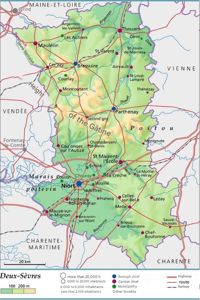
The capital, largest city, and prefecture of the Deux-Sèvres department is Niort, while its subprefectures are Bressuire and Parthenay. In demographic terms, the inhabitants of Deux-Sèvres currently number 376,773. Given the department’s total area of 5,999 km², the population density is 63 inhabitants per square kilometre. Finally, department 79 is divided into 3 arrondissements, 3 legislative constituencies, 17 cantons, 7 intermunicipal authorities, and 256 municipalities.

What are the neighboring departments of the Deux-Sèvres department?
Since the territory occupied by department 79 is located in the western part of the country, a large part of the territory it occupies is part of the Armorican Massif. In addition to its belonging to the Nouvelle Aquitaine region, the Deux-Sèvres department has the Vienne department bordering it to the East as a neighboring department. There is also the Charente-Maritime department which borders it to the southwest.
What is the climate of Deux-Sèvres?
Given that the Deux-Sèvres department is very close to the sea, that is only 80 km away, the climate is therefore oceanic. And this type of climate is really marked throughout all seasons. Indeed, there is also the fact that there are many mountain ranges and hills in the territory of Deux-Sèvres, which causes a significant drop in temperature in the region.
This makes the winter period much colder. So, this also greatly influences precipitation, meaning that the rains are much more abundant in the western part and a bit less rainy in the east.
So, overall, it is known that winters are a bit milder and wetter as you get closer to the coast. The summer periods are much drier and storms are numerous with heavy precipitation. On the other hand, in the southern part of the department, it is warmer than in the northern part.
What are the most important cities in the Deux-Sèvres department?
We have established this ranking to offer you the most populated cities of 79, namely the Deux-Sèvres department:
- Niort
- Bressuire
- Thouars
- Parthenay
- Mauléon
- Chauray
- Saint-Maixent-L’Ecole
- Mellé
- La Crèche
- Nueil-les-Aubiers
What are the largest communes in the Deux-Sèvres department?
To establish this ranking, we referred to the area of the communes in the Deux-Sèvres department, so here are the 10 largest communes of 79
- Bressuire
- Mauléon
- Nueil-les-Aubiers
- Vasles
- Niort
- La Forêt-sur-Sèvre
- Rom
- Assais-les-Jumeaux
- Gourgé
- Airvault

FAQ – Deux-Sèvres map
A map of Deux-Sèvres helps you locate the department’s main towns, road networks, and natural areas. It also provides a better understanding of the region’s layout before traveling or exploring.
A map makes it easier to identify tourist attractions, municipalities, and the most convenient travel routes. It also helps optimize your itinerary and save time during your visit.
Yes, it is useful for finding your way, organizing trips, or discovering new places nearby. It is also an excellent resource for educational activities and geographic research.
