📋 Key takeaway: Personally, I believe that understanding Morocco’s territorial organization and the hierarchy of its major metropolises is essential for intelligently structuring a travel itinerary. Between coastal economic hubs and inland oases, each region has its own transport dynamics.
.synthesis h2, .synthesis .synthesis-header { font-size: 1.15em; font-weight: 700; margin-bottom: 0.6em; color: #47752c; }
.synthesis p, .synthesis li { font-size: 1em; line-height: 1.65; margin: 10px; }
.synthesis strong { color: #121e0b; }
.synthesis table { width: 100%; border-collapse: collapse; }
.synthesis th { background: rgba(91, 150, 56, 0.12); color: #47752c; text-align: left; }
.synthesis td, .synthesis th { padding: 8px 12px; border-bottom: 1px solid rgba(91, 150, 56, 0.18); vertical-align: top; }
.synthesis tbody tr:nth-child(even) { background: rgba(91, 150, 56, 0.05); }
.key-takeaways { max-width: 640px; margin: 2em auto; padding: 1.5em 1.8em; color: #1f3313; font-family: “Inter”, “Segoe UI”, sans-serif; text-align: left; position: relative; box-sizing: border-box; background: #f2f7ef; border: 1px solid #5b9638; border-left: 6px solid #5b9638; border-radius: 12px; box-shadow: 0 8px 24px rgba(251, 191, 36, 0.15); }
.key-takeaways h2, .key-takeaways .key-takeaways-header { font-size: 1.15em; font-weight: 700; margin-bottom: 0.6em; color: #47752c; }
.key-takeaways p, .key-takeaways li { font-size: 1em; line-height: 1.65; margin: 10px; }
.key-takeaways strong { color: #121e0b; }
.key-takeaways ul { list-style: none; padding-left: 0; }
.key-takeaways li { margin: 0.45em 0; padding-left: 0.2em; }
.mg-callout{margin:1.5em 0;padding:.9em 1.1em;border:1px solid;border-left-width:4px;border-radius:10px;font-size:.97em;line-height:1.65}.mg-callout>:first-child{margin-top:0}.mg-callout>:last-child{margin-bottom:0}.mg-callout__label{display:block;margin:0 0 .35em;font-weight:700;font-size:.82em;letter-spacing:.03em;text-transform:uppercase}.mg-callout__label::before{margin-right:.45em;font-size:1.05em;vertical-align:-.06em}.mg-callout–info{background:#eff6ff;border-color:#bfdbfe;color:#1e3a5f}.mg-callout–info .mg-callout__label{color:#2563eb}.mg-callout–info .mg-callout__label::before{content:”\2139\FE0F”}.mg-callout–tip{background:#f0fdf4;border-color:#bbf7d0;color:#14532d}.mg-callout–tip .mg-callout__label{color:#15803d}.mg-callout–tip .mg-callout__label::before{content:”\1F4A1″}.mg-callout–warning{background:#fffbeb;border-color:#fde68a;color:#7a4a10}.mg-callout–warning .mg-callout__label{color:#b45309}.mg-callout–warning .mg-callout__label::before{content:”\26A0\FE0F”}.mg-callout–danger{background:#fef2f2;border-color:#fecaca;color:#7f1d1d}.mg-callout–danger .mg-callout__label{color:#dc2626}.mg-callout–danger .mg-callout__label::before{content:”\1F6D1″}.mg-proscons{display:grid;grid-template-columns:1fr 1fr;gap:16px;margin:1.5em 0}@media(max-width:560px){.mg-proscons{grid-template-columns:1fr}}.mg-proscons__col{padding:.9em 1.1em;border:1px solid;border-radius:10px}.mg-proscons__title{display:flex;align-items:center;gap:.4em;margin:0 0 .5em;font-weight:700;font-size:.9em;letter-spacing:.02em}.mg-proscons__col ul{margin:.3em 0 0;padding-left:1.15em}.mg-proscons__col li{margin:.3em 0;line-height:1.55}.mg-proscons__col–pro{background:#f0fdf4;border-color:#bbf7d0;color:#14532d}.mg-proscons__col–pro .mg-proscons__title{color:#15803d}.mg-proscons__col–pro .mg-proscons__title::before{content:”\2705″}.mg-proscons__col–con{background:#fef2f2;border-color:#fecaca;color:#7f1d1d}.mg-proscons__col–con .mg-proscons__title{color:#dc2626}.mg-proscons__col–con .mg-proscons__title::before{content:”\274C”}ol.mg-steps{list-style:none!important;counter-reset:mgstep;margin:1.6em 0;padding-left:0!important}ol.mg-steps>li.mg-steps__item{counter-increment:mgstep;list-style:none!important;padding-left:0!important;padding-bottom:1.4em}ol.mg-steps>li.mg-steps__item:last-child{padding-bottom:0}ol.mg-steps>li.mg-steps__item>:last-child{margin-bottom:0}ol.mg-steps>li.mg-steps__item>.mg-steps__title{margin:0 0 .25em;font-weight:600}ol.mg-steps>li.mg-steps__item>.mg-steps__title::before{content:counter(mgstep) “. “;opacity:.45;font-weight:500;font-variant-numeric:tabular-nums}ol.mg-steps>li.mg-steps__item:not(:has(.mg-steps__title))::before{content:counter(mgstep) “. “;opacity:.45;font-weight:500;font-variant-numeric:tabular-nums}.mg-kpis{display:grid;grid-template-columns:repeat(auto-fit,minmax(140px,1fr));gap:14px;margin:1.5em 0}.mg-kpi{padding:1em .9em;border:1px solid #e5e7eb;border-radius:12px;background:#f9fafb;text-align:center}.mg-kpi__value{display:block;font-size:1.7em;font-weight:800;line-height:1.15;color:#111827}.mg-kpi__label{display:block;margin-top:.35em;font-size:.85em;color:#6b7280;line-height:1.35}
.wp-block-image,.ai-image{margin-bottom:1.75em}.wp-block-image>figcaption,.ai-image>figcaption{margin-top:.5em}
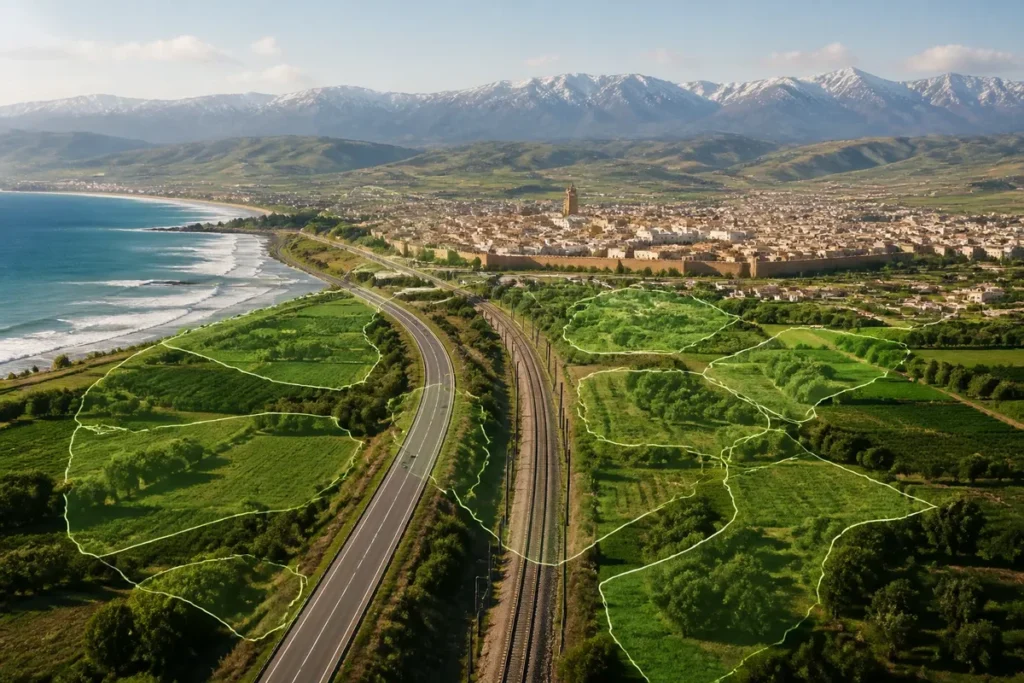
Today, Morocco is structured into 12 regions, from Tanger-Tétouan-Al Hoceïma in the north to Dakhla-Oued Ed-Dahab in the south. However, a clear Morocco map must show more than just an administrative division: it must highlight the coasts, mountains, plains, road axes, and the actual location of major cities.
🌟 My experience: Crossing the country from Tangier to the gates of the South, I realized how the transition between the major coastal highways and the inland roads completely redefines the concept of travel time. This geographical reality taught me never to underestimate intercity distances.
The difficulty lies in the scale. Casablanca, Rabat, and Tangier follow each other relatively closely along the Atlantic and Mediterranean coastlines, while Marrakech, Ouarzazate, Errachidia, Laâyoune, or Dakhla are located in much larger spaces. The map thus becomes a navigation tool, not just an image to look at.


| 🗺️ | Territory: Morocco stretches between the Mediterranean, Atlantic, interior reliefs, and Saharan areas. |
| 📍 | Organization: the country has 12 administrative regions, subdivided into prefectures, provinces, and communes. |
| 🏙️ | Major cities: Rabat is the political capital, Casablanca the main economic hub, and Marrakech a major tourist center. |
| ⛰️ | Reliefs: the Rif, Middle Atlas, High Atlas, and Anti-Atlas shape movements and landscapes. |
| 🚆 | Axes: the Atlantic coast concentrates the most continuous connections between Tangier, Rabat, Casablanca, and Agadir. |
| 🧭 | Practical reading: a tourist map helps prepare an itinerary, while a topographic map specifies altitudes and mountain passes. |
To structure your travels across the territory, I suggest you consult visiting Morocco as part of an unforgettable trip to find itinerary ideas. You can also explore our tips for preparing your trip to Morocco, as well as our dedicated guide to discover Marrakech and its immediate surroundings.
What are the major geographical landmarks of Morocco?
Morocco is first understood through its maritime fronts and mountain ranges: the Mediterranean borders the north, the Atlantic Ocean accompanies the west, then the reliefs and plateaus organize the interior before the transition to pre-Saharan and Saharan areas.
The north of the country is marked by the Rif, a mountain range close to the Mediterranean. Tangier is located at the western entrance of the Strait of Gibraltar, Tetouan faces the Mediterranean coast, and Al Hoceima is nestled in a more rugged coastline. The orientation seems simple on a general map, but road distances increase quickly as soon as the relief imposes detours.

Further south, the Middle Atlas and High Atlas form two essential landmarks. The Middle Atlas notably frames the areas of Fès, Ifrane, Khénifra, and Midelt. The High Atlas rises south of Marrakech and separates the Atlantic plains from the valleys oriented towards Ouarzazate, Tinghir, or Errachidia.
The physical map then shows an alternation of Atlantic plains, plateaus, deep valleys, and arid zones. For altitudes, mountain passes, and the nature of the reliefs, the topographic map of Morocco provides a more precise reading than a general road map.
💡 Did you know? Morocco inaugurated the first high-speed rail line (LGV) in North Africa, named Al Boraq, connecting Tangier to Casablanca in record time and redefining the centrality of major coastal cities.
The coastline facilitates orientation, the relief explains the detours. A route that seems short as the crow flies can become long as soon as it crosses the Atlas, skirts a valley, or leaves the main roads.
To the east, the Oriental region is organized around Oujda and the plateaus near the Algerian border. To the southwest, Souss-Massa forms a transition zone between the Atlantic, agricultural plains, and the reliefs of the Anti-Atlas. Further south, the landscapes gradually become pre-Saharan, then Saharan, with very spaced-out towns.
How is the Moroccan territory administratively organized?
Morocco is organized into 12 administrative regions. Each groups prefectures or provinces, which themselves consist of communes; this division is used to manage public policies, even if it does not exactly reproduce the borders of mountains, basins, or cultural areas.
⚠️ Classic trap: Thinking that travel times between the interior lands (Atlas, South) and the coastal metropolises are calculated solely based on the kilometer distance, without taking into account the relief and the winding nature of the roads.
The 12 regions are as follows:
- Tangier-Tetouan-Al Hoceima;
- Oriental;
- Fès-Meknès;
- Rabat-Salé-Kénitra;
- Béni Mellal-Khénifra;
- Casablanca-Settat;
- Marrakech-Safi;
- Drâa-Tafilalet;
- Souss-Massa;
- Guelmim-Oued Noun;
- Laâyoune-Sakia El Hamra;
- Dakhla-Oued Ed-Dahab.
This division is useful for locating a city, understanding the role of a regional council, or situating an infrastructure project. However, one should not confuse an administrative region with a geographical entity: Marrakech-Safi includes Atlantic and mountainous areas, while Drâa-Tafilalet gathers vast interior territories with very different landscapes.

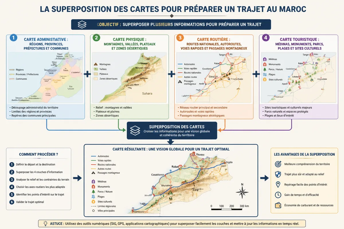
However, administrative maps are not enough to prepare a trip. They indicate who manages a territory, not the quality of a road, the duration of a transfer, or the condition of a mountain pass after a period of rain. To travel, you need to overlay several pieces of information.
- Administrative map: regions, provinces, prefectures, and municipalities.
- Physical map: mountains, valleys, plateaus, and desert areas.
- Road map: national roads, highways, expressways, and mountain passes.
- Tourist map: medinas, monuments, parks, beaches, and cultural sites.
The official portal of local authorities remains the reference for verifying administrative boundaries and titles. A printed map or a cartographic service may display an old name, a simplified boundary, or a neighboring municipality; for an official procedure, the administrative source prevails.
What are the main cities to locate on a map of Morocco?
The major Moroccan cities are distributed between the Atlantic coast, the Mediterranean north, the interior plains, and the southern regions. Rabat, Casablanca, Tangier, Fes, Marrakech, and Agadir form the most useful landmarks to quickly understand the urban structure of the country.
⏱ Practical advice: Favor the major highways to quickly connect the metropolises along the Atlantic axis, and reserve the small secondary roads for immersion stops inland and in the mountain ranges.
Rabat is the political and administrative capital. It is located on the Atlantic coast, north of Casablanca, with Salé on the other side of the Bouregreg. Casablanca, further south, concentrates a large part of the economic, port, and industrial functions. Between the two cities, the highway and railway axis is particularly structuring.

Tangier occupies a particular position at the far northwest of the country, facing Europe and near the Strait of Gibraltar. Tetouan is further east, at the foot of the Rif, while Nador is located on the eastern Mediterranean coast. These cities do not play the same role: Tangier is a major maritime entry point, while Tetouan and Nador structure distinct regional areas.
Fes and Meknes form two major landmarks of the northern interior. Fes is known for its medina and its historical role, while Meknes is located to the west, on an axis linking the Rabat region to that of Fes. Oujda, further east, commands part of the Oriental region and constitutes an important point for reading the eastern border.

Marrakech is located north of the High Atlas, in a foothill position that explains its tourist importance and its role as a gateway to the southern valleys. Agadir is further west, on the Atlantic coast, at the heart of the Souss-Massa area. Essaouira, Safi, and El Jadida complete the chain of coastal cities between the center and the southwest.

In the South, Laâyoune and Dakhla appear as two major urban centers of the southern regions. Laâyoune is associated with the Laâyoune-Sakia El Hamra region, while Dakhla belongs to Dakhla-Oued Ed-Dahab. The distances between cities are considerable: a national map gives a direction, not a sufficient estimate of travel time.
🍀 Advantages
• Modern transport network on the main axis
• Marked economic and cultural diversity between regions
• Increasing accessibility of large metropolitan areas
🔻 Disadvantages
• Development disparities between the coast and the hinterland
• High traffic density at the entrances of large cities
• Logistical complexity to connect certain isolated areas
How to locate the 12 regions on a map of Morocco?
To read the Moroccan regions without memorizing them mechanically, start from the northwest and then go down along the Atlantic before returning inland and south. This method associates each region with a coastline, a main city, and a type of landscape.
| Region | Main city or landmark | Geographical area to remember |
|---|---|---|
| Tanger-Tétouan-Al Hoceïma | Tanger, Tétouan | Strait, Rif and Mediterranean coasts |
| l’Oriental | Oujda, Nador | Eastern plateaus and Mediterranean frontage |
| Rabat-Salé-Kénitra | Rabat, Kénitra | Atlantic center and Sebou valley |
| Casablanca-Settat | Casablanca, Settat | Large Atlantic plain and economic hub |
| Fès-Meknès | Fès, Meknès | Interior north, plateaus and historic cities |
| Marrakech-Safi | Marrakech, Safi | Atlantic, plains and foothills of the High Atlas |
| Souss-Massa | Agadir | Agadir Bay, Souss plain and Anti-Atlas |
| Drâa-Tafilalet | Errachidia, Ouarzazate | Pre-Saharan valleys and eastern slopes of the Atlas |
| Southern Regions | Guelmim, Laâyoune, Dakhla | Pre-Saharan transition and Saharan areas |
In the north, Tanger-Tétouan-Al Hoceïma and l’Oriental flank the coasts of the strait, the Rif, and the Mediterranean. In the center, Rabat-Salé-Kénitra and Casablanca-Settat concentrate the main political, economic, and logistical functions of the country.
In the interior, Fès-Meknès is located north of the Middle Atlas, while Béni Mellal-Khénifra extends towards the central reliefs and plains. Marrakech-Safi combines a large tourist city, an Atlantic coast, and access to the High Atlas.

Finally, Souss-Massa, Guelmim-Oued Noun, Laâyoune-Sakia El Hamra, and Dakhla-Oued Ed-Dahab extend the reading towards the south. Here, regional areas are large and cities much more spaced out. A detailed map becomes essential to distinguish a coastal route from an inland connection.
For travel preparation, the tourist maps of Morocco are the most useful to link cities, monuments, and stops. For an administrative or territorial file, it is better to use an official map of the regions.
What are the main axes to orient oneself on a map of Morocco?
Moroccan axes are understood around a large Atlantic diagonal, interior connections between imperial cities, and passages through the Atlas. The coast provides a continuous direction; the mountains then impose route choices that are not always visible on a simplified map.
The Atlantic axis connects Tanger, Rabat, Casablanca, El Jadida, Safi, Essaouira, and Agadir, with variations depending on the chosen road. It concentrates the closest cities and the most readable infrastructures. For a first stay, it is the simplest itinerary to understand on a national map.
An internal axis notably connects Fès, Meknès, Béni Mellal, and Marrakech. The distances do not follow a perfectly straight line, as the cities are nestled between plains, plateaus, and reliefs. The road between Marrakech and Ouarzazate, for example, crosses the High Atlas: the season, weather, and condition of the pass matter more than the displayed distance alone.
However, a road map never guarantees a travel time. Construction, slowdowns at the entrance of urban areas, and weather conditions alter the actual time, especially in mountainous zones.
In the South, routes lengthen significantly between Guelmim, Laâyoune, and Dakhla. Stations, available services, and departure schedules deserve verification before leaving a major city. On site, the mobile network and displayed information may be less consistent than in main urban centers.
To connect several cities in a few days, stay on the Atlantic coast. To see the reliefs, accept longer stages and do not fill each day as if mountain passes did not exist.

A vector map can be practical for modifying colors, isolating regions, or preparing a presentation. The guide dedicated to using a vector map of Morocco addresses this graphic use, while a navigation app remains preferable to check an updated route.
What a map of Morocco really allows you to understand
A map of Morocco connects four levels of reading: the position of cities, the shape of regions, the constraints of the relief, and the logic of major axes. It becomes truly useful when this information is cross-referenced, as no single map provides administration, altitude, and traffic conditions all at once.
The first mistake is to treat the country as a homogeneous surface. Tangier, Casablanca, Marrakech, and Dakhla are not only distant on a map: they belong to distinct coastal, climatic, and road contexts. The second mistake is to believe that a regional border automatically indicates a landscape break.
To choose a map, use this simple grid:
- You are looking for regions: take a recent administrative map.
- You are preparing a tour: add the routes, transfer times, and stopover cities.
- You are exploring the Atlas: check the altitudes, mountain passes, and the season.
- You are looking for monuments: use a detailed tourist map.
- You are designing a support: prioritize a vector file with a clear legend.
Useful sources to consult
To verify geographic or administrative information, start with the source suited to the need. A tourist map can be excellent for choosing a viewpoint and unsuitable for defining a region.
| Source | Useful data | Practical use | Warning |
|---|---|---|---|
| National portal of local authorities | Regions and territorial organization | Verify an administrative division | Compare the update date |
| High Commission for Planning | Demographic and territorial data | Contextualize the size of a city | Do not confuse municipal population with urban area |
| National railway office | Rail network and services | Prepare connections between major cities | Schedules change depending on the date |
| Updated cartographic and road sources | Roads, works, and routes | Estimate a trip | Check conditions on the day of departure |
Population figures, municipal boundaries, and infrastructures evolve. For a map used in an official document, always check its date, legend, and the organization that produced it.
.magic-lb-overlay.open{display:flex}
.magic-lb-overlay img{max-width:95vw;max-height:95vh;object-fit:contain;border-radius:8px;box-shadow:0 8px 32px rgba(0,0,0,.5)}
.magic-lb-close{position:absolute;top:16px;right:20px;color:#fff;background:rgba(0,0,0,.5);border:none;width:40px;height:40px;border-radius:50%;font-size:24px;cursor:pointer;display:flex;align-items:center;justify-content:center}
.magic-lb-close:hover{background:rgba(0,0,0,.8)}
.wp-block-image img{cursor:zoom-in;transition:transform .15s ease}
.wp-block-image img:hover{transform:scale(1.01)}
.magic-img-link{display:inline-block;text-decoration:none}
(function(){
var ov=document.getElementById(‘magic-lb’);if(!ov)return;
var img=ov.querySelector(‘img’),btn=ov.querySelector(‘.magic-lb-close’);
var L={fr:’Fermer’,es:’Cerrar’,en:’Close’,pt:’Fechar’,it:’Chiudi’,de:’Schlie\u00dfen’,nl:’Sluiten’,ca:’Tancar’};
btn.setAttribute(‘aria-label’,L[(document.documentElement.lang||”).slice(0,2).toLowerCase()]||’Close’);
function open(src){img.src=src;ov.classList.add(‘open’);document.body.style.overflow=’hidden’}
function close(){ov.classList.remove(‘open’);img.src=”;document.body.style.overflow=”}
document.addEventListener(‘click’,function(e){
var a=e.target.closest(‘a.magic-img-link’);
if(a){e.preventDefault();open(a.getAttribute(‘href’));return}
var i=e.target.closest(‘.wp-block-image img’);
if(i&&!e.target.closest(‘a’)){e.preventDefault();open(i.currentSrc||i.src)}
});
ov.addEventListener(‘click’,function(e){if(e.target===ov||e.target===btn)close()});
document.addEventListener(‘keydown’,function(e){if(e.key===’Escape’)close()});
})();