
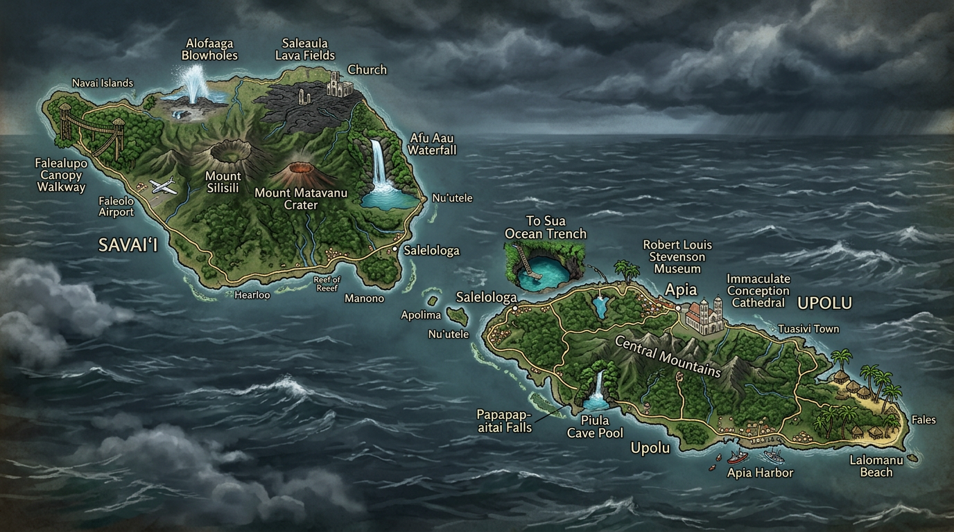
The Samoa Islands, located in the heart of the South Pacific, captivate with their natural beauty and unique culture. Exploring this archipelago using a geographical map allows for a better visualization of the layout of the islands, their main cities, as well as the particularities of each inhabited territory. Whether to prepare for a trip or simply to satisfy curiosity, understanding the spatial organization of this small piece of Polynesia offers an enriching perspective on this little-known destination.
Where are the Samoa Islands located on a geographical map?
The archipelago of the Samoa Islands stretches across the South Pacific Ocean, halfway between Hawaii and New Zealand. This group formed by several islands is situated right in the heart of Oceania, more precisely in the Polynesian region. Most geographical maps depicting the Pacific highlight the isolated yet strategic position of Samoa, an important passage point for many sailors.
The territory of the Samoa Islands is often divided into two distinct entities on the map: the independent state of Samoa, also called Western Samoa, and the American part, known as American Samoa. These two neighboring blocks reflect a shared history but different political trajectories, which are particularly visible in the urban planning and infrastructure seen from a cartographic view.
What are the main islands of the Samoa archipelago?
When observing a geographical map of the Samoa Islands, two names immediately stand out: Savai’i and Upolu. These two islands make up the bulk of the western Samoan territory and host the majority of the population as well as important economic activities.
Surrounding these large lands are small inhabited islands like Manono and Apolima, all occupied for centuries. Even though they appear tiny next to Savai’i or Upolu, they play an essential role in the identity and daily life of the Samoans. Together, these different islands drawn on the map offer a mosaic of tropical landscapes and vibrant traditions.
Savai’i: The nature island par excellence
Savai’i is among the largest islands of Polynesia. On a geographical map, it occupies a prominent place to the west of the archipelago. Its reputation rests as much on its impressive volcanic landscapes as on its lush forests and preserved wildlife. Sparsely populated compared to its size, Savai’i embodies the wild and authentic side of the Samoa Islands.
There are a few main cities in the south and east, but many villages scattered along the coast. This particular spatial distribution is evident when analyzing thematic maps focused on human density and road infrastructure. Savai’i is also famous for its pristine beaches, easily identifiable on satellite images or tourist map backgrounds.
Upolu: The economic and political center
Upolu appears just east of Savai’i on the geographical map of the Samoa Islands. Smaller in area but much more urbanized, it hosts the capital Apia and concentrates the majority of administrative, commercial services, as well as numerous tourist attractions. Its mountainous relief, visible on some topographic representations, creates varied environments ranging from lively coasts to perched villages.
The layout of roads and urban centers around Apia reflects a dynamism that contrasts with the peaceful atmosphere of Savai’i. Several other localities also appear on regional maps, enriching Upolu with a very lively network despite its relatively modest size.
What are the other inhabited islands of the archipelago?
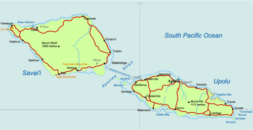
Besides Savai’i and Upolu, the geographical map of the Samoa islands also lists small island units such as Manono, Apolima, and Namua. Each, in its own way, contributes to the cultural and natural richness of the region while offering a unique way of life.
Long explored by the Samoan populations, these islets still retain an intimate and peaceful atmosphere today. Their presence on the map reminds us that the diversity of habitats in the archipelago goes far beyond the main centers and invites one to venture off the beaten path.
Manono: Between tradition and tranquility
Located halfway between Savai’i and Upolu, Manono stands out for its almost total absence of cars and modern infrastructure. The geographical map highlights its low urban development and its proximity to neighboring islands. On site, life follows an ancestral rhythm marked by fishing and community living.
This preserved character makes Manono an essential stop for anyone wishing to feel the authentic spirit of Polynesia. Visitors can easily find their way thanks to the few paths indicated on local maps, guiding them to villages, historical sites, and the island’s secluded beaches.
Apolima and Namua: Island microcosms
Apolima brightens maritime maps with its discreet silhouette, nestled not far from Manono. It holds the title of the least populated inhabited island in the Samoa archipelago. Accessible only by boat, Apolima offers an environment where time seems suspended, far from the bustle of the larger islands.
Namua, for its part, mainly attracts hiking enthusiasts and day-trippers. Easily identifiable on hiking trail maps, this island remains permanently uninhabited but is used for temporary stays. These micro-islands complete the image of the archipelago, revealing the variety of lifestyles possible on such a small territory.
What does the geographical map of the Samoa islands look like?
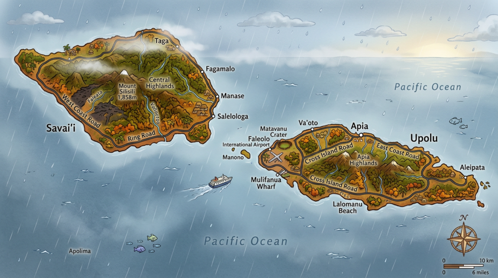
On a classic geographical map, the Samoa islands appear as an irregular crescent-shaped constellation, oriented from west to east. Savai’i dominates on the left, followed by Upolu and then the satellites Manono, Apolima, and Namua aligned according to an almost symmetrical natural architecture. The maritime borders are well identified, illustrating the separation between independent Samoa and American Samoa.
Regarding details, maps dedicated to the region highlight volcanic reliefs, the coral lagoon, as well as routes connecting the main cities and major tourist sites. It is also on this type of document that natural reserves, ports, and several points of interest specific to each island are shown.
- Savai’i, the largest and highest, concentrates forest areas and extinct volcanoes.
- Upolu, the second vital center, reveals the capital Apia to the north and splendid beaches distributed around its perimeter.
- Manono remains identifiable by its small size and limited accessibility.
- Apolima, tiny and remote, mainly attracts for the absolute calm offered by its steep slopes.
- Namua and other small islets finally punctuate the map, living testimonies of the natural heritage of Polynesia.
What types of maps to explore to better navigate the archipelago?
To understand the complex geography of the Samoa islands, there are different categories of geographical maps, each meeting a specific need. Travelers generally favor tourist maps, practical for quickly locating the main cities, beaches, hiking trails, and available accommodations in the archipelago.
These coexist with more technical documents, such as detailed topographic bases or nautical charts. Each of these resources provides a complementary view of the realities on the ground, allowing for precise planning of a stay or better understanding of the distribution of the Samoan territory.
Cycling Maps and Hiking Trails
With pleasant weather all year round and the absence of excessive relief in some areas, cycling maps are very popular among two-wheel enthusiasts eager to explore the inhabited islands differently. Trails, marked walks, and major natural sites are clearly shown on this type of map.
Especially since these maps sometimes include travel times and elevation changes, giving everyone the chance to customize their route according to their physical condition and sense of adventure. For those who prefer walking, other maps list all accessible trails, from coastal villages to the wooded ridges of Savai’i or Upolu.
Interactive Maps and Mobile Applications
With technological advances, more and more travelers consult interactive maps to prepare their stay in the Samoa Islands. Many mobile applications now allow precise navigation, offline consultation, and flexible selection of points to visit.
These digital tools have the advantage of combining practical information with real-time data on events or the location of various strategic sites in the territory. They help ensure nothing is missed among the curiosities often hidden far from the main tourist routes.
How to Understand the Structure of Main Cities and Territories on the Map?
The urban and territorial organization of the Samoa Islands follows a traditional logic that is clearly readable on the geographical map. On Upolu, the capital Apia acts as a central hub connected by road to other localities. This reflects the concentration of human activities around a single site, thus facilitating exchanges and travel.
On Savai’i, the pattern changes radically: the main towns are scattered along the coast, following an ancient tradition of villages oriented towards the sea rather than the wooded interior. This self-sufficient model sometimes limits major road axes, giving rise to settlements radiating around family nuclei rather than large administrative centers.
- Apia, the nerve center of modern Samoan life
- Salelologa, the main access and commercial point on Savai’i
- Safotu and Asau, secondary hubs orchestrating rural dynamics
- Vailoa, Matautu, and Lalomanu, examples of emblematic villages on Upolu or Savai’i
Careful analysis of the geographical map also reveals the dispersion of schools, medical, or religious establishments, key elements of local life sometimes located at a good distance from each other. This scattered organization outlines a supportive society, rooted in respect for collective traditions.
Finally, taking the time to explore the multiple facets of the archipelago through its maps encourages a fresh perspective on the history, ecology, and creativity of its inhabitants. Every imagined itinerary promises discoveries and renews the desire to meet these fascinating lands, harmoniously balancing modernity and ancestral heritage.
