
Exploring the Dominican Republic means setting out to discover varied landscapes, paradisiacal beaches, and a fascinating history in the Caribbean. To properly prepare your trip or deepen your knowledge of the country, a good reading of the different geographical maps is essential.
What are we trying to visualize: the major regions, the capital Santo Domingo, the main roads, or simply where the must-see cities are located? Reviewing the use of a tourist map or a city plan helps not only to understand the geographical situation of the country but also to efficiently organize your travels.
Table – Dominican Republic: Geographic and demographic information
| Element | Key Information |
|---|---|
| Total area | 48,671 km² |
| Capital | Santo Domingo |
| Neighboring countries | Haiti (island of Hispaniola) |
| Coastline | ~1,600 km on the Caribbean Sea and the Atlantic Ocean |
| Estimated population | ~11.4 million inhabitants (2025) |
| Population density | ~235 inhabitants/km² |
| Relief | Mountain ranges (Pico Duarte, 3,098 m), fertile plains, beaches |
| Climate | Humid tropical, with hurricane season |
| Official language | Spanish |
| Economic resources | Tourism, sugar, cocoa, nickel, textiles |
| Particularity | Most touristic country in the Caribbean, occupying the eastern two-thirds of Hispaniola |
Additional points on the map of the Dominican Republic
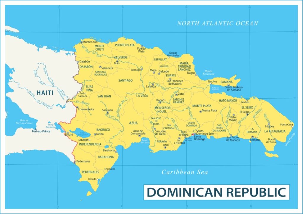
- Located in the Caribbean, the Dominican Republic occupies two-thirds of the island of Hispaniola, which it shares with Haiti.
- The physical map shows a contrasting relief with mountains, valleys, and long sandy coasts.
- The country is bordered by the Caribbean Sea to the south and the Atlantic Ocean to the north.
- The capital, Santo Domingo, is the oldest colonial city in the New World.
- The country attracts millions of visitors thanks to its beaches, resorts, and culture.
The map of the Dominican Republic illustrates a state of the Greater Antilles, located on the island of Hispaniola which it shares with Haiti. Bordered by the Atlantic Ocean to the north and the Caribbean Sea to the south, the country is renowned for its beaches, mountains, and its historic capital, Santo Domingo.
Why use a map of the Dominican Republic?
A geographical map of the Dominican Republic offers an essential overview to locate this territory at the heart of the Antilles. Situated on the island of Hispaniola which it shares with Haiti, this nation attracts by the variety of its landscapes, from its mountains to its long Caribbean beaches, as well as its large modern cities.

Studying a tourist map also allows identifying major points of interest such as Punta Cana, Puerto Plata, Santiago, or the capital Saint-Domingue. This type of resource guides choices when planning an itinerary on site and highlights sometimes lesser-known places, like the Del Este National Park or the Samaná Peninsula.
Geographical location, area, and provinces of the country
The strategic geographical location of the Dominican Republic in the Caribbean Sea provides privileged access to turquoise waters and the natural riches of the Antilles. Thanks to a detailed map, it becomes easy to see how this state occupies nearly two-thirds of the island of Hispaniola, southeast of Cuba and west of Puerto Rico.
With an area of approximately 48,670 km², the Dominican Republic stands out as one of the largest island nations in this region. Its population now exceeds ten million inhabitants, spread between urban and rural areas, all organized into several provinces with distinct identities. The boundaries of these administrative entities appear clearly on a political map, useful for understanding the territorial organization of the country.
What are the advantages of using a political map?
Consulting a political map allows easily differentiating each province, locating their names as well as the location of their capitals. One can easily find the twenty-nine provinces and the national district that hosts the capital, Saint-Domingue. This precise organization promotes understanding of local issues and facilitates the management of various administrative procedures for residents or visitors.

To organize a tour through the regions, this format of map remains the best tool as it highlights internal borders, provides an overview of the state structure, and simplifies administrative and logistical navigation within the country.
How to appreciate the diversity of regions and provinces?
Each province has unique characteristics, both cultural and geographical. On a detailed map, one can easily distinguish Cibao in the north, famous for its valleys and mountains, or the eastern region which attracts with its popular beaches. These distinctions help travelers choose an area according to their interests, whether hiking, relaxing, or urban exploration.
Careful observation of a road map also allows exploring the diversity of the country independently, easily connecting coastal areas to inland regions without risking missing essential stops.

Several types of maps exist to approach the Dominican Republic from different perspectives. Each offers a specific approach adapted to a precise use, whether to discover the main cities, assess distances, or plan tailor-made adventures.
The main types of maps used remain:
- Classic geographical map, showing reliefs, watercourses, mountain ranges, and natural borders.
- Road map, essential for all those planning a road trip, highlighting the network of main and secondary roads.
- Political map, valuable for easily locating provinces, districts, and the capital.
- Detailed city maps to explore Santo Domingo or Santiago.
- Tourist map indicating beaches, historical sites, and nature reserves.
Using several types of maps greatly enriches the preparation of a stay or the in-depth study of the territory.
Discover the main cities and their detailed maps
Santo Domingo is not only the administrative capital; it is also a cultural and economic center where colonial heritage, museums, and lively neighborhoods intersect. A precise city map is essential here to navigate between the colonial zone, the large modern boulevards, markets, and popular squares.
Santiago de los Caballeros, the country’s second city, impresses with its dynamism and institutions. Consulting a city map of Santiago reveals a different layout, with very identifiable residential, industrial, and commercial districts. Even experienced travelers benefit from using these urban maps to miss nothing during their visit.
Which other urban centers deserve to be located?
Beyond Santo Domingo and Santiago, coastal cities like Puerto Plata, La Romana, or San Pedro de Macorís deserve to be pinpointed on a tourist map. They often offer direct access to renowned beaches or remarkable historical sites.
Finding these destinations, through the analysis of a road map or a tourist map, protects against common errors when planning routes. It also helps to concretely measure the distances separating these attractive hubs.
Where to find detailed downtown maps?
To move efficiently in the major local metropolises, downtown maps reveal the many alleys, monuments, and green spaces without risk of unnecessary detours. Access to this information speeds up the discovery of typical restaurants, art galleries, or emblematic museums often scattered across different neighborhoods.
By choosing an interactive or printed map dedicated to Dominican urban centers, it is possible to optimize one’s time on site and avoid unpleasant surprises inherent to unnecessary back-and-forths.
Easily find your way during a trip or from home
Even before departure, taking the time to examine the various formats of geographical maps, political or tourist, ensures a global vision of the country. Some mainly look for updated road maps, others rely on city maps for a route focused on cultural visits.
Mentally mapping the Dominican Republic from home allows better anticipation of transit points, accommodation locations, and regional particularities, leaving nothing to chance. Thus, each new stage already feels familiar during the trip, reducing stress related to the unknown.
Usefulness of a tourist map to enjoy local riches
The tourist map of the Dominican Republic is not limited to the beaten paths. In addition to the internationally renowned dream beaches, it also highlights nature reserves, authentic villages, and diving spots. The available maps showcase hidden treasures off the classic routes, ideal for customizing your stay.
Thanks to these visual aids, enriching your program with countryside or seaside getaways becomes easy. These aids accompany explorers in discovering hidden valleys, clear lagoons, and small fishing ports lining both the northern and southern coasts.
Can we rely on the new digital versions of maps?
With the rise of mobile applications, consulting an interactive map on your smartphone has become common. You then benefit from frequent updates and practical features, such as place searches, creating personalized routes, and instant geolocation regardless of specific needs.
However, many travelers remain attached to the paper version of a road or tourist map, especially to avoid unforeseen issues related to network coverage, which are common in mountainous or isolated areas.
What elements should you spot first on a tourist map?
Generally, the legends of these tourist maps clearly distinguish beaches, ecological reserves, archaeological sites, and craft centers. Spotting these places on the map from the start helps build a logical itinerary, explore each region methodically, and enjoy the specificities of each visited province.
To optimize both a short stay and a long trip, setting some priorities proves wise. A well-thought-out route avoids unnecessary kilometers and maximizes the discovery of remarkable spots in the Dominican territory.
FAQ – Dominican Republic map
It is located on the island of Hispaniola, in the Greater Antilles, east of Haiti.
The capital is Santo Domingo, founded in 1498.
A mountainous territory, bordered by tropical coasts, with a warm climate and a strong tourism vocation.
