
Diving into the world of Haiti through its maps opens a window onto an island full of contrasts, natural wonders, and cultural diversity. The many types of maps allow exploration of every aspect of the territory, from physical geography to administrative divisions, including the roads connecting cities and departments. Whether you are a travel enthusiast, passionate about cartography, or curious to better understand this Caribbean nation, this article offers a comprehensive overview to navigate the heart of Haiti with suitable images and illustrations.
Table – Haiti: Geographical and demographic information
| Element | Key Information |
|---|---|
| Total area | 27,750 km² |
| Capital | Port-au-Prince |
| Neighboring countries | Dominican Republic (island of Hispaniola) |
| Coastline | ~1,771 km on the Caribbean Sea and the Atlantic Ocean |
| Estimated population | ~11.7 million inhabitants (2025) |
| Population density | ~420 inhabitants/km² |
| Relief | Mountains (Chaîne de la Selle, Pic la Selle 2,680 m), plains and coastal plateaus |
| Climate | Humid tropical with cyclone season |
| Official languages | French, Haitian Creole |
| Economic resources | Coffee, mangoes, textiles, tourism (struggling) |
| Particularity | First independent state in the Caribbean (1804) and the only one resulting from a successful slave revolt |
Additional points on the map of Haiti
- Haiti occupies the western third of the island of Hispaniola, which it shares with the Dominican Republic.
- The physical map shows a very mountainous relief, which limits arable land.
- Its coastline is long and indented, with many bays and peninsulas.
- The capital Port-au-Prince is located in the bay of the same name.
- The country is regularly exposed to cyclones and earthquakes.
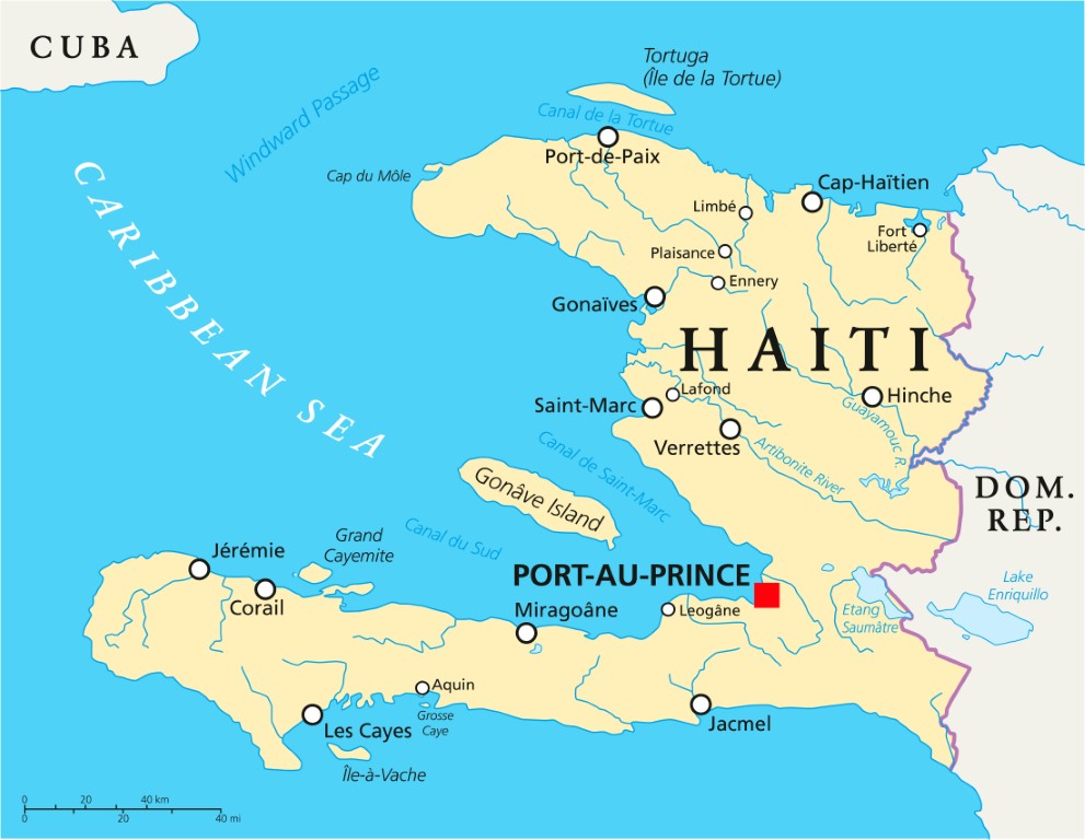
The map of Haiti highlights a Caribbean country located on the island of Hispaniola, which it shares with the Dominican Republic. Its territory is mainly mountainous, bordered by a coastline on the Caribbean Sea and the Atlantic Ocean, with Port-au-Prince as its capital.
Geography of Haiti: between mountains, plains, and coastline
The geography of Haiti is characterized by a great variety of reliefs, marked by mountain ranges dominating the landscape, vast fertile plains, and rugged coasts bordering the Caribbean Sea. Understanding these elements often involves careful reading of a physical map adapted to the region, offering a clear view of the natural specificities of the territory.

Physical maps reveal how mountain ranges like the Selle chain or the Northern chain form the backbone of the island. The coastal plains, such as the Artibonite plain, offer a different perspective, ideal for locating large agricultural areas and the main urban zones. Using these images also helps to better understand why certain parts of the country are more isolated or difficult to access, notably due to the rugged terrain.
Diversity of map types to explore Haiti
To discover Haiti in all its facets, relying on different types of maps remains essential. Each provides a unique perspective depending on what one wishes to know or explore further: territorial organization, remarkable tourist sites, or precise location of road networks and major points of interest.
What does an administrative map of Haiti provide?
An administrative map makes it easier to visualize the official boundaries between departments, cities, and municipalities. These subdivisions play a key role in the political and logistical organization of the country. On these precisely drawn maps, it becomes simple to find a particular department, then zoom into its municipalities, locate where each zone begins, and understand how they fit into the national whole.

Beyond this macro approach, many also use the administrative map to track demographic changes or plan field actions, whether humanitarian, logistical, or economic. Interest grows as soon as one wants to learn about the distribution of administrative, educational, or health services in Haiti, each image providing essential details.
What advantages does a physical map hold?
The physical map of Haiti invites reading the relief, altitudes, and main waterways at a glance. From a practical point of view, it helps anticipate routes, but also to choose itineraries less exposed to natural risks – earthquakes, floods, or landslides being unfortunately frequent on the island.
Many detailed illustrations also highlight major natural sites like the Saut-d’Eau waterfalls or Macaya park. By delving into topographic detail, one then discovers the ecological richness of the country and the potential difficulty of connecting certain villages by car or on foot, which is reflected as well by both road maps and illustrated maps.
How to use a tourist map of Haiti to prepare your stay?
Turning to tourist maps allows choosing the best destinations and organizing travel without forgetting any must-see sites. Colors often differentiate beaches, historic monuments, nature reserves, or local markets, sometimes even offering a playful touch close to the illustrated or animated map.
With these dedicated supports, it becomes easier to plan a route, quickly spot recommended accommodations, and avoid less accessible areas during the rainy season. Visitors also appreciate the small icons indicating museums, viewpoints, or renowned beaches. This kind of customized map proves useful for both families and independent travelers, facilitating the discovery of Haitian heritage.
What is the purpose of a detailed road map of Haiti?
The Haitian road network is not always easy to grasp without visual support. The road map highlights the main routes connecting the principal cities and departments, as well as every secondary road serving villages and remote sites. For anyone planning to travel by bus, rental car, or taxi, this map format offers a truly practical and reliable guide.

Some prefer traditional printed versions, while others today favor digital tools incorporating interactive features. In all cases, these maps help anticipate traffic jams, possible roadworks, or difficulties related to road conditions after intense weather events. Traveling with peace of mind therefore begins with good map reading and up-to-date images.
Organization of the country: cities, departments, and essential landmarks
Haiti has ten departments grouping hundreds of municipalities, each with its own characteristics and variable population density. An administrative map shows their precise borders and makes the overall layout of the territory visible, while displaying the relationships between the different territorial units for a complete understanding.
On a map detailing cities and departments, one can easily identify the capital Port-au-Prince, located in the West, Cap-Haïtien in the north, Jacmel in the southeast, not forgetting Gonaïves, Jérémie, or Les Cayes. Alongside the major urban centers, the tourist potential of more remote areas often begins with an adequate visual location on the map:
- Port-au-Prince: administrative, economic, and cultural center
- Cap-Haïtien: historic gateway to the North
- Jacmel: creative and seaside town appreciated
- Pétion-Ville: dynamic residential and commercial area
- Saint-Marc, Miragoâne, Hinche: often overlooked regional crossroads
Taking an interest in the representation of cities and departments on different images provides a concrete vision of the distances and travel times necessary to explore the Haitian mosaic. Several guides also offer illustrated maps paying tribute to the landscapes, local traditions, and colorful market scenes specific to each area, thus enriching the discovery of the country.
The importance of cartographic images and illustrations for understanding Haiti
A particular aspect of the map lies in its ability to let the images speak as much as the raw data. For certain audiences, notably children, students, or foreign travelers, an illustrated map quickly captures attention while delivering a maximum of visual information. These mixed media, combining drawings, pictograms, and clear legends, translate the diversity of the Haitian environment and make geography accessible to all.
Combining illustrations, aerial photos, and well-thought-out legends allows both contextualizing each piece of information and making consultation enjoyable. One thus encounters artistic representations inspired by local life, highlighting crafts, dance, regional festivals, or gastronomy. Creativity serving geographical understanding promotes learning while awakening curiosity, thanks to maps rich in images.
Why regularly consult a new map of Haiti?
The territory of Haiti is continuously evolving due to natural transformations, development projects, or occasional administrative reconfigurations. Having an updated map therefore ensures reliable data when preparing for a trip, organizing a local event, or supporting a professional mission on site.
Choosing the right type of map depends on current needs: a quick online consultation is sometimes enough, especially to compare two departments or check a distance. Professional or educational use, on the other hand, may require a large-format paper map, enriched with manual annotations or specific images, especially since administrative accuracy influences the success of many collective projects.
How to select the best map according to your objectives?
Between physical, administrative, road, or illustrated maps, making a choice depends on the pursued goal. Identifying an optimal route, exploring an emerging tourist destination, or simply learning to locate each city then requires combining several complementary formats for a rich and effective experience.
Many opt for the juxtaposition of digital practices (interactive consultation, satellite images) and more traditional media, such as the essential foldable or wall map, ideal for orientation at any time. The key remains to favor recognized sources, offering regular updates and integrating various relevant illustrations to ensure a smooth and precise reading of the Haitian territory.
FAQ – Haiti map
Haiti is located in the Greater Antilles, on the island of Hispaniola, west of the Dominican Republic.
The capital is Port-au-Prince, in the central-west of the country, on the edge of the bay.
A mountainous country with a very indented coastline, it is exposed to natural risks such as hurricanes and earthquakes.
