
California immediately evokes mythical landscapes, roads along the Pacific coast, and a multitude of different atmospheres. To truly grasp the full diversity of this vast state in the American West, nothing beats exploring through a geographical map tailored to your needs. Whether to prepare a trip, choose typical towns and villages to visit, or better understand the organization of the territory, the map quickly becomes a valuable ally. Following the road axes and locating the tourist sites on a detailed map allows you to optimize your stay, or simply dream of new horizons.
Why use a map of California?
Whatever the motivation of the traveler or the curious, reading a geographical map of California brings a new dimension of understanding. It offers a global view of the size of the state, the layout of towns and villages, the notable natural regions, as well as the location of national parks. A good map allows you to dive into the relief, visualize the distribution between deserts, mountains, and beaches, and quickly target areas that deserve special attention.
Road trip enthusiasts often rely on a road map to plan their itineraries. This type of support highlights the main routes, showcasing the legendary Highway 1, Route 66, or the Interstate 5 which connects the north to the south of the state. Thanks to detailed maps of cities like San Francisco, Los Angeles, or San Diego, it becomes easier to organize yourself and quickly find the neighborhoods to explore.
The different types of California maps available
To meet all needs, several types of maps exist. Each offers a different angle, allowing you to adapt your discovery according to your desires and mode of travel. From large wall formats intended for contemplation to small practical maps slipped into your pocket, there is always a suitable solution.
Before diving into the details, here are the main categories encountered when searching for a map dedicated to California.
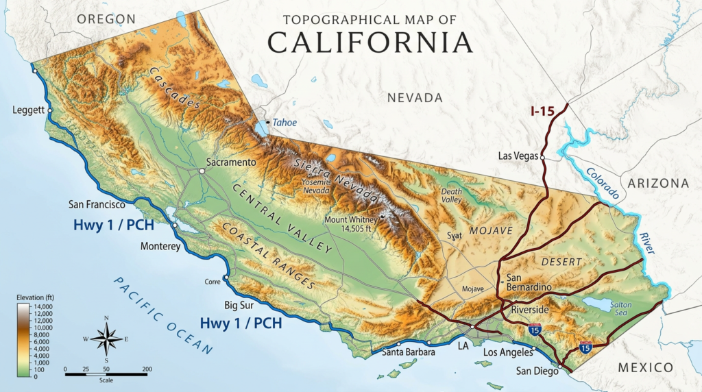
- Classic geographical map to visualize the relief and internal borders.
- Road map focused on road axes and main routes to organize a car journey.
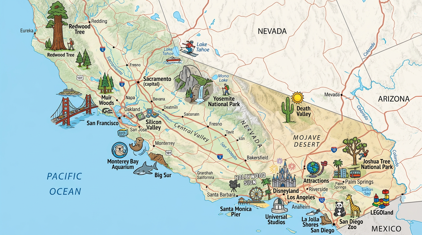
- Tourist map highlighting tourist sites, points of interest, and recommended itineraries.
- Detailed map dedicated to a large city or a specific region to optimize visits in the heart of an urban area.
- Thematic map specifically illustrating national parks and nature reserves.
- Cartographic images and illustrations artistic or historical offering a different perspective of the territory.
The geographical map: understanding relief, climates, and organization
To grasp the scale of California, a geographical map immediately provides a clear reading. One can distinguish the major natural units: the Sierra Nevada mountains, the desert expanse of Death Valley, the lush forests of the north, and the beaches of the Pacific coast. These elements appear thanks to different color codes sometimes enhanced by cartographic images and illustrations.
This approach also promotes understanding of local climates, largely influenced by the proximity of the ocean and mountain ranges. Such maps also reveal the major Californian regions, like the San Francisco Bay, the agricultural Central Valley, or the sunny south around Los Angeles and San Diego.
The road map: Essential for touring the state
Exploring California without referring to a road map would mean missing a thousand opportunities for practical discoveries. The density of the network, signage, and hierarchy of roadways become clear thanks to these specific maps. The journey between iconic cities like San Francisco, Santa Barbara, Yosemite, or Palm Springs becomes simpler.
This resource also highlights the sometimes impressive distances separating two major points of interest. Visualizing the logical sequence of tourist sites by following the main routes offers a real advantage for organizing a balanced trip between relaxation, culture, and natural adventure.
The tourist map: customized trips for all profiles
A detailed map designed for visitors cleverly combines recommended itineraries, circuit proposals, and precise locations of essential tourist sites. On such a map, each national park and nature reserve is easily identifiable among the names of towns and villages with varying degrees of renown.
From tourism professionals to independent adventurers, many appreciate these playful resources featuring pictograms and cartographic images and illustrations representing famous beaches, renowned vineyards, or remarkable museums. This turns trip planning into a treasure hunt!
Locating national parks and booking nature stops
California has about thirty national parks and countless nature reserves. Numerous thematic maps are dedicated to them for those who wish to prioritize hiking, wildlife observation, or exploring unique landscapes.
To quickly locate Yosemite, Sequoia, Joshua Tree, or Death Valley, nothing beats synthetic representations. A detailed map of the various access points and protected areas helps anticipate accommodation, travel durations, and iconic viewpoints.
Cities and villages: Guiding urban and rural discoveries
When the goal is to soak up the Californian atmosphere, the tourist map offers a varied selection of towns and villages spread throughout the territory. Whether it’s about finding the hidden gem nestled in the hills or spotting the must-sees for a first visit, the approach proves rewarding.
The multitude of localities, from Sacramento to Carmel-by-the-Sea, passing through Santa Monica or Redding, invites travelers off the beaten path. The varied destinations offered allow for composing original getaways far from the well-known metropolitan areas alone.
Focus on neighboring states and regions to contextualize California
Situating California among neighboring states and regions sheds light on its strategic position on the West Coast. The geographical map therefore often includes borders with Oregon to the north, Nevada to the east, and Arizona to the southeast. Identifying these interactions facilitates understanding migratory, economic, and ecological dynamics between California and its immediate environment.
The cartographic study also highlights the opening towards the Pacific and the historical link with Mexico. Integrating these aspects broadens the very notion of map, which is no longer just utilitarian but also cultural and historical.
Detailed maps to explore each specific region
Each sector of California deserves to be approached through a distinct detailed map. For example, the Central Coast is full of wild coves while the large basin of Lake Tahoe allows marveling at alpine panoramas.
Having regional maps on hand for highly touristic areas (San Francisco Bay, Los Angeles County, Wine Country, Silicon Valley…) opens the door to a finer exploration. These maps generally offer a precise focus on local attractions, small villages, and secondary roads not to be overlooked.
The contribution of modern images and cartographic illustrations
Today, the map often becomes interactive or illustrative. Custom-designed infographics offer a unique perspective on thematic networks: unusual places, gastronomic sites, mural paintings… Modern images and cartographic illustrations accompany the eye and spark curiosity.
This visual abundance makes learning playful: contemplating the gold rush map, admiring the stylized representation of natural parks, understanding the distribution of major agricultural crops… All these inspirations push beyond the traditional and static image of the paper map.
Some tips for choosing a California map
Finding the ideal map depends primarily on the project: long road trip, quick city break, or quest for visual inspiration. Favor detailed plans in foldable format for urban explorations, and rely on road maps covering all of California when it comes to connecting several tourist sites far from each other.
For hiking or outdoor sports enthusiasts, nothing beats a specialized map of chosen national parks and nature reserves. Finally, opting for design images and cartographic illustrations can completely transform wall decoration or inspire a future itinerary.
List of features to watch for when making your choice
- Legibility of symbols, colors, and legends explained in French
- Recent update of road or tourist information
- Presence of main routes and clearly indicated distances
- Inclusion of national parks, nature reserves, and major points of interest
- Varied formats (durable paper, wall poster, interactive digital version)
Ultimately, traveling in California with a good map means putting all the odds in your favor to fully enjoy this land of adventure, striking contrasts, and unexpected encounters.
