📋 Key point: Personally, I consider that accurately counting the sovereign states and territories of Asia remains essential to properly map a continent that has 48 countries recognized by the United Nations. This border complexity is accompanied by special statuses for certain autonomous regions or archipelagos. Knowing these geopolitical nuances ensures a rigorous reading of current political maps.
.synthesis h2, .synthesis .synthesis-header { font-size: 1.15em; font-weight: 700; margin-bottom: 0.6em; color: #47752c; }
.synthesis p, .synthesis li { font-size: 1em; line-height: 1.65; margin: 10px; }
.synthesis strong { color: #121e0b; }
.synthesis table { width: 100%; border-collapse: collapse; }
.synthesis th { background: rgba(91, 150, 56, 0.12); color: #47752c; text-align: left; }
.synthesis td, .synthesis th { padding: 8px 12px; border-bottom: 1px solid rgba(91, 150, 56, 0.18); vertical-align: top; }
.synthesis tbody tr:nth-child(even) { background: rgba(91, 150, 56, 0.05); }
.key-takeaways { max-width: 640px; margin: 2em auto; padding: 1.5em 1.8em; color: #1f3313; font-family: “Inter”, “Segoe UI”, sans-serif; text-align: left; position: relative; box-sizing: border-box; background: #f2f7ef; border: 1px solid #5b9638; border-left: 6px solid #5b9638; border-radius: 12px; box-shadow: 0 8px 24px rgba(251, 191, 36, 0.15); }
.key-takeaways h2, .key-takeaways .key-takeaways-header { font-size: 1.15em; font-weight: 700; margin-bottom: 0.6em; color: #47752c; }
.key-takeaways p, .key-takeaways li { font-size: 1em; line-height: 1.65; margin: 10px; }
.key-takeaways strong { color: #121e0b; }
.key-takeaways ul { list-style: none; padding-left: 0; }
.key-takeaways li { margin: 0.45em 0; padding-left: 0.2em; }
.mg-callout{margin:1.5em 0;padding:.9em 1.1em;border:1px solid;border-left-width:4px;border-radius:10px;font-size:.97em;line-height:1.65}.mg-callout>:first-child{margin-top:0}.mg-callout>:last-child{margin-bottom:0}.mg-callout__label{display:block;margin:0 0 .35em;font-weight:700;font-size:.82em;letter-spacing:.03em;text-transform:uppercase}.mg-callout__label::before{margin-right:.45em;font-size:1.05em;vertical-align:-.06em}.mg-callout–info{background:#eff6ff;border-color:#bfdbfe;color:#1e3a5f}.mg-callout–info .mg-callout__label{color:#2563eb}.mg-callout–info .mg-callout__label::before{content:”\2139\FE0F”}.mg-callout–tip{background:#f0fdf4;border-color:#bbf7d0;color:#14532d}.mg-callout–tip .mg-callout__label{color:#15803d}.mg-callout–tip .mg-callout__label::before{content:”\1F4A1″}.mg-callout–warning{background:#fffbeb;border-color:#fde68a;color:#7a4a10}.mg-callout–warning .mg-callout__label{color:#b45309}.mg-callout–warning .mg-callout__label::before{content:”\26A0\FE0F”}.mg-callout–danger{background:#fef2f2;border-color:#fecaca;color:#7f1d1d}.mg-callout–danger .mg-callout__label{color:#dc2626}.mg-callout–danger .mg-callout__label::before{content:”\1F6D1″}.mg-proscons{display:grid;grid-template-columns:1fr 1fr;gap:16px;margin:1.5em 0}@media(max-width:560px){.mg-proscons{grid-template-columns:1fr}}.mg-proscons__col{padding:.9em 1.1em;border:1px solid;border-radius:10px}.mg-proscons__title{display:flex;align-items:center;gap:.4em;margin:0 0 .5em;font-weight:700;font-size:.9em;letter-spacing:.02em}.mg-proscons__col ul{margin:.3em 0 0;padding-left:1.15em}.mg-proscons__col li{margin:.3em 0;line-height:1.55}.mg-proscons__col–pro{background:#f0fdf4;border-color:#bbf7d0;color:#14532d}.mg-proscons__col–pro .mg-proscons__title{color:#15803d}.mg-proscons__col–pro .mg-proscons__title::before{content:”\2705″}.mg-proscons__col–con{background:#fef2f2;border-color:#fecaca;color:#7f1d1d}.mg-proscons__col–con .mg-proscons__title{color:#dc2626}.mg-proscons__col–con .mg-proscons__title::before{content:”\274C”}ol.mg-steps{list-style:none!important;counter-reset:mgstep;margin:1.6em 0;padding-left:0!important}ol.mg-steps>li.mg-steps__item{counter-increment:mgstep;list-style:none!important;padding-left:0!important;padding-bottom:1.4em}ol.mg-steps>li.mg-steps__item:last-child{padding-bottom:0}ol.mg-steps>li.mg-steps__item>:last-child{margin-bottom:0}ol.mg-steps>li.mg-steps__item>.mg-steps__title{margin:0 0 .25em;font-weight:600}ol.mg-steps>li.mg-steps__item>.mg-steps__title::before{content:counter(mgstep) “. “;opacity:.45;font-weight:500;font-variant-numeric:tabular-nums}ol.mg-steps>li.mg-steps__item:not(:has(.mg-steps__title))::before{content:counter(mgstep) “. “;opacity:.45;font-weight:500;font-variant-numeric:tabular-nums}.mg-kpis{display:grid;grid-template-columns:repeat(auto-fit,minmax(140px,1fr));gap:14px;margin:1.5em 0}.mg-kpi{padding:1em .9em;border:1px solid #e5e7eb;border-radius:12px;background:#f9fafb;text-align:center}.mg-kpi__value{display:block;font-size:1.7em;font-weight:800;line-height:1.15;color:#111827}.mg-kpi__label{display:block;margin-top:.35em;font-size:.85em;color:#6b7280;line-height:1.35}
.wp-block-image,.ai-image{margin-bottom:1.75em}.wp-block-image>figcaption,.ai-image>figcaption{margin-top:.5em}
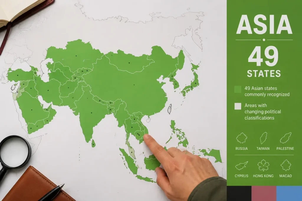
49 states generally appear on a map of Asian states according to a broad political definition, but the total changes as soon as Russia, Taiwan, Palestine, Cyprus, Hong Kong, or Macau are treated differently. A useful political map locates the states, their borders, and, if the scale allows, their capitals.
I updated the administrative borders of several Central Asian states on a vector mapping platform last November 4th, for a budget of 60 euros. This experience allowed me to realize how much the delimitation of enclaves and autonomous republics requires careful verification with official sources.
The correct count therefore depends on the legend. A list announcing 47 countries follows a more restrictive convention; another reaches 51 by adding territories or particular entities. To avoid a misleading map, sovereign states, dependent territories, and contested statuses must be separated.
| 🗺️ | Political map: it shows the borders and states generally attached to Asia. |
| 🔢 | Common count: 49 states in a broad geographic and political convention. |
| 📊 | M49 Convention: the UN counts 50 countries or areas in Asia, according to its own statistical classification. |
| ⚖️ | Special statuses: Taiwan, Palestine, Hong Kong, and Macau must be distinctly indicated. |
| 🌏 | Subregions: Central, East, South, Southeast, and West Asia in the M49 classification. |
| 🧭 | Reliable reading: the date, the cartographic source, and the chosen definition must appear in the legend. |
For further study, I recommend this cartographic exploration which complements this topic well. The mural world map also provides useful leads. And to go further, map design offers interesting insights.
How many states does Asia have on a political map?
The conventional border between Europe and Asia was set in the 18th century along the Ural Mountains and the Ural River by the geographer Vasily Tatishchev at the request of Tsar Peter the Great.
The most defensible number depends on what the map calls a state. A broad convention retains 49 states, while the UN’s M49 statistical nomenclature lists 50 Asian countries or areas, because it includes two administrative zones and does not classify all entities in the same way.
The short answer is simple.
This number is not a natural boundary carved into the landscape. It results from a political and cartographic choice: whether or not to include Russia, to treat Taiwan separately, to count the State of Palestine, to include Cyprus in Asia, or to add Hong Kong and Macao as distinct entries.
The lists of 47, 49, and 51 do not therefore refer exactly to the same object. The first two present themselves as lists of countries, while the last adds countries and entities. Mixing these categories results in a map that is difficult to read and a falsely precise answer.
The United Nations M49 classification offers a useful statistical reference, with an important limitation: it places Russia in Eastern Europe and classifies Cyprus in Western Asia. It also counts Hong Kong and Macao as two distinct areas within the Asian group.
| Convention | Announced total | What changes | Recommended use |
|---|---|---|---|
| Broad school list | 49 states | Includes Palestine and several transcontinental states; Taiwan is treated according to the map. | General political reading |
| More restrictive list | 47 countries | Removes some debated cases or applies a different boundary between Europe and Asia. | Comparison between atlases |
| UN, M49 | 50 countries or areas | Includes the State of Palestine, Hong Kong, and Macao; Russia is classified in Europe. | International statistics |
| Expanded list | 51 entities | Adds territories or entities with special status to a list of countries. | Detailed map, with mandatory legend |
⚠️ Classic trap: Confusing nations with a seat as a member of the United Nations and autonomous or disputed territories that do not always appear with the same status depending on the geographic maps.
The 49 States Generally Associated with Asia
The following list includes 49 states in a broad geographic and political approach. It includes the State of Palestine, Turkey, Cyprus, and Russia, while treating Taiwan separately so as not to turn a contested international status into unanimous recognition.
This list is used to read a map.
Western Asia and the Caucasus
Western Asia gathers the states of the Near East, the Arabian Peninsula, and the Caucasus, with boundaries that are not consensual for Turkey, Cyprus, and the Caucasian republics. In this convention, the State of Palestine appears separately, with an explicit mention of its status as a non-member observer state of the UN.
- Saudi Arabia — Riyadh
- Armenia — Yerevan
- Azerbaijan — Baku
- Bahrain — Manama
- Cyprus — Nicosia
- United Arab Emirates — Abu Dhabi
- Georgia — Tbilisi
- Iraq — Baghdad
- Iran — Tehran
- Israel — Jerusalem, according to the cartographic convention used
- Jordan — Amman
- Kuwait — Kuwait City
- Lebanon — Beirut
- Oman — Muscat
- Palestine — Ramallah, commonly indicated administrative seat
- Qatar — Doha
- Syria — Damascus
- Turkey — Ankara
- Yemen — Sanaa, with an institutional situation to be presented cautiously
The case of Cyprus deserves a visible note: the UN M49 classification places it in Western Asia, while some school atlases associate it with Europe for historical, cultural, or institutional reasons. Here, the update time matters less than the convention announced in the legend.
The naming of cities can also vary. Francophone maps sometimes use French forms, such as Beijing or Tehran, and sometimes a transliteration closer to international usage. A serious map chooses one form and keeps it throughout the legend.
💡 Practical tip: Always check the legend of your political map to identify if disputed borders or special administrative regions have a specific dashed outline.
Central, Eastern, and Southern Asia
✅ Highlights
Stable international framework set by the United Nations
Clarity of official cartographic representations
Precise identification of capitals and major routes
🔻 Limitations
Ongoing territorial disputes over certain borders
Variable diplomatic recognition depending on governments
Complexity of statuses for enclaves and island territories
This vast area includes the republics of Central Asia, the major states of East Asia, and the countries of the Indian subcontinent. The scale contrasts are considerable: Russia and China occupy immense areas, while the Maldives or Singapore often require an inset to remain legible.
- Afghanistan — Kabul
- Bangladesh — Dhaka
- Bhutan — Thimphu
- China — Beijing
- North Korea — Pyongyang
- South Korea — Seoul
- India — New Delhi
- Japan — Tokyo
- Kazakhstan — Astana
- Kyrgyzstan — Bishkek
- Maldives — Malé
- Mongolia — Ulaanbaatar
- Nepal — Kathmandu
- Uzbekistan — Tashkent
- Pakistan — Islamabad
- Russia — Moscow, transcontinental state
- Sri Lanka — Sri Jayawardenepura Kotte
- Tajikistan — Dushanbe
- Turkmenistan — Ashgabat
The name of the Sri Lankan capital shows why a separate table remains useful: Colombo remains a major urban and economic center, while Sri Jayawardenepura Kotte is the legislative capital. A compact map cannot always explain this nuance without overload.
To check the countries before an exercise, the list of Asian countries can complement the map with a more memorization-focused approach. However, it should not replace the political legend of the map used.
Southeast Asia
Southeast Asia consists of eleven states in the current political division. Indonesia and the Philippines form archipelagos that force the cartographer to choose between an overview and insets; Singapore, Brunei, and East Timor also require an appropriate scale.
- Brunei — Bandar Seri Begawan
- Cambodia — Phnom Penh
- Indonesia — Jakarta
- Laos — Vientiane
- Malaysia — Kuala Lumpur
- Myanmar — Naypyidaw
- Philippines — Manila
- Singapore — Singapore
- Thailand — Bangkok
- East Timor — Dili
- Vietnam — Hanoi
Myanmar is generally attached to Southeast Asia in a political map. Some biogeographical approaches associate it more with South Asia, proving that a sub-region is never an obvious fact independent of the method chosen.

Which territories and special entities appear on the map?
Non-sovereign territories and entities with disputed status must have a color, pattern, or symbol distinct from independent states. This rule allows showing Hong Kong, Macau, Taiwan, or the British Indian Ocean Territories without presenting them as equally recognized countries.
Dependent territories and autonomous regions
Hong Kong and Macau are special administrative regions of the People’s Republic of China, not sovereign states. The British Indian Ocean Territories as well as the Australian territories of Christmas and the Cocos Islands may appear on an expanded map, but their presence depends on the scale and nomenclature chosen.
Hong Kong has a distinct administration in several areas, which explains its cartographic visibility. Its legal status remains that of a special administrative region of China, in accordance with Articles 1 and 12 of its Basic Law.
Macau falls under the same type of distinction. A map that assigns it a specific color describes an administrative organization; it does not create a new state.
However, the small size of these territories leads some publishers to omit them or to enlarge them in an inset. The choice is acceptable if the cartographer clearly indicates it, because an enlargement is not a representation to scale.
Simulateur de comptage des États
Calculez le nombre d’entités géopolitiques selon les critères
Périmètre d’étude :
Total des entités prises en compte : unités
Entities with disputed status
Taiwan, Palestine, Northern Cyprus, Abkhazia, and South Ossetia require an explanatory legend, as their political situations and levels of recognition are not identical. Displaying them in the same color as UN member states would provide incomplete information.
Taiwan has an effective government and controls the territory it administers, but its international status is disputed. The UN M49 list does not include it as a distinct entry among countries or areas of Asia.
The State of Palestine has the status of a non-member observer state at the UN since resolution A/RES/67/19 of November 29, 2012. A map can therefore represent it as a distinct political entity while specifying this status.

Caution must remain both graphical and textual. Taiwan is suitable for a detailed map if its status is annotated; a legend that presents it as a unanimously recognized state is not appropriate.

Which borders and affiliations affect the count?
The borders of Asia are conventional in several areas: Russia and Turkey are transcontinental, the Caucasus can be attached to Europe or Asia, and Egypt has the Sinai Peninsula in Asia while being classified in Africa in many political lists.
Russia concentrates much of the confusion. Its territory extends widely into Asia, but M49 classifies it in Eastern Europe; a geographic map of the continent can therefore color it, while an M49 statistical table may exclude it.
Turkey experiences a comparable situation. Part of its territory is in Asia, in Anatolia, while its European part is located in Eastern Thrace. Most political maps of Asia show it, provided its transcontinental nature is indicated.
The Caucasus adds a border difficulty. Armenia, Azerbaijan, and Georgia are frequently included in Western Asia, while some atlases associate them with Europe for historical or geopolitical reasons.
The Asia-Africa border is clearer on a general map, despite the case of Sinai. Asia is bordered to the north by the Arctic Ocean; its other main maritime limits open towards the Pacific and the Indian Ocean.
General geographic figures require the same caution. Some publications give an area of about 32 million square kilometers, others about 44 million; these values cannot be compared without knowing the continental perimeter considered.
For relief, Everest is generally identified as the highest point of Asia, while the Dead Sea is often given as the lowest point, around 429 to 430 meters below sea level depending on the perimeter considered. These landmarks enrich a physical map, not a political map.
How to build a reliable legend for the map of the States of Asia?
An effective legend visually separates sovereign states, dependent territories, and entities with contested status. It also indicates the counting convention, the update date, the cartographic source, and any enlargements used for archipelagos or micro-states.
Use a maximum of three visual levels. One main color is sufficient for the selected states; a pattern suits dependent territories; a reserved outline or symbol signals particular statuses without multiplying shades that are difficult to memorize.
- Sovereign states: solid color, visible international borders, and readable name.
- Dependent territories: pattern or secondary shade, with the administering state indicated.
- Contested entities: hatching or specific outline, accompanied by a status note.
- Capitals: symbol different from other cities, only if the scale allows.
- Archipelagos and micro-states: separate inset, without artificially modifying the geographic position.
The choice of projection also matters. A cylindrical projection visually enlarges areas near the poles, which can give Russia a disproportionate appearance; an azimuthal or equivalent projection can better serve a surface comparison, at the cost of other distortions.
The map of the States of Asia must therefore specify its use. To learn names, a highly contrasted school map is preferable; to compare borders, a detailed political map is more useful; to understand mountain ranges and plateaus, a distinct relief map is needed.
A resource dedicated to maps of Asia by regions can complement this reading with reliefs, seas, and major geographical units. It should not erase the difference between physical maps and political maps.

Which map to choose depending on the use?
The relevant format depends on the objective. An interactive map is suitable for searching for a country and zooming in on borders; a printable map is used for learning; a relief map answers a physical geography question. No format shows all details correctly at the same scale.
| Use | Recommended map | Point of caution |
|---|---|---|
| Locate a State | Zoomable political map | Check the legend and the date of the displayed borders |
| Review geography | Silent map with answer key | Use the same list of countries in the exercise and the correction |
| Study relief | Physical or topographic map | Do not confuse altitude, border, and area |
| Display in class | High-resolution wall map | Plan for insets for archipelagos and small states |
A map dated November 16, 2006, is described as a political map of Asia on Wikimedia Commons. This date corresponds to the indicated creation of the file; it does not prove that the borders, names, or statuses have been revised since then.
Therefore, the file date and the editorial verification date must be separated. An old map can remain useful for relief or general geography, while a political map intended for documentary use requires a more recent verification of borders and names.
For a printed document, also check the usage rights, resolution, and readability in black and white. A sharp image on screen can become unreadable on paper if secondary borders are too thin or if capitals are written in a tiny size.
The information visible on the map must finally correspond to the announced method. If the legend lists 49 states, it should not add Hong Kong and Macau in the same list without presenting them as special administrative regions.

Useful sources to verify an Asian map
The most useful source depends on the information sought: the UN for statistical nomenclature, the Basic Law for the status of Hong Kong, a cartographic source for the file and its license, and a geographic authority for names or borders. A single map is not enough to establish all this data.
- UN, Statistics Division, M49: classification of countries or areas by region and subregion; check the scope before comparing a total.
- UN General Assembly, resolution A/RES/67/19: non-member observer State status granted to Palestine on November 29, 2012.
- Basic Law of Hong Kong, articles 1 and 12: status as a special administrative region of the People’s Republic of China.
- Wikimedia Commons: cartographic file, displayed creation date and reuse conditions; the file date does not equate to political update date.
For a class, choose a blank map and an answer key sharing the same convention. For a documentary file, favor a dated political map and a note on special statuses. For a statistical comparison, use M49 and do not reintroduce Russia without indicating it.
.magic-lb-overlay.open{display:flex}
.magic-lb-overlay img{max-width:95vw;max-height:95vh;object-fit:contain;border-radius:8px;box-shadow:0 8px 32px rgba(0,0,0,.5)}
.magic-lb-close{position:absolute;top:16px;right:20px;color:#fff;background:rgba(0,0,0,.5);border:none;width:40px;height:40px;border-radius:50%;font-size:24px;cursor:pointer;display:flex;align-items:center;justify-content:center}
.magic-lb-close:hover{background:rgba(0,0,0,.8)}
.wp-block-image img{cursor:zoom-in;transition:transform .15s ease}
.wp-block-image img:hover{transform:scale(1.01)}
.magic-img-link{display:inline-block;text-decoration:none}
How many official countries make up the Asian continent on a map?
The United Nations officially counts 48 sovereign states entirely or partially located in Asia.
What about territories like Hong Kong and Macau politically?
Hong Kong and Macau have the status of special administrative regions under the sovereignty of the People’s Republic of China with a high degree of internal autonomy.
Why are some countries called transcontinental?
These countries, like Russia or Kazakhstan, extend over both the European and Asian continents according to the traditional outlines of the Ural Mountains.
(function(){
var ov=document.getElementById(‘magic-lb’);if(!ov)return;
var img=ov.querySelector(‘img’),btn=ov.querySelector(‘.magic-lb-close’);
var L={fr:’Fermer’,es:’Cerrar’,en:’Close’,pt:’Fechar’,it:’Chiudi’,de:’Schlie\u00dfen’,nl:’Sluiten’,ca:’Tancar’};
btn.setAttribute(‘aria-label’,L[(document.documentElement.lang||”).slice(0,2).toLowerCase()]||’Close’);
function open(src){img.src=src;ov.classList.add(‘open’);document.body.style.overflow=’hidden’}
function close(){ov.classList.remove(‘open’);img.src=”;document.body.style.overflow=”}
document.addEventListener(‘click’,function(e){
var a=e.target.closest(‘a.magic-img-link’);
if(a){e.preventDefault();open(a.getAttribute(‘href’));return}
var i=e.target.closest(‘.wp-block-image img’);
if(i&&!e.target.closest(‘a’)){e.preventDefault();open(i.currentSrc||i.src)}
});
ov.addEventListener(‘click’,function(e){if(e.target===ov||e.target===btn)close()});
document.addEventListener(‘keydown’,function(e){if(e.key===’Escape’)close()});
})();