
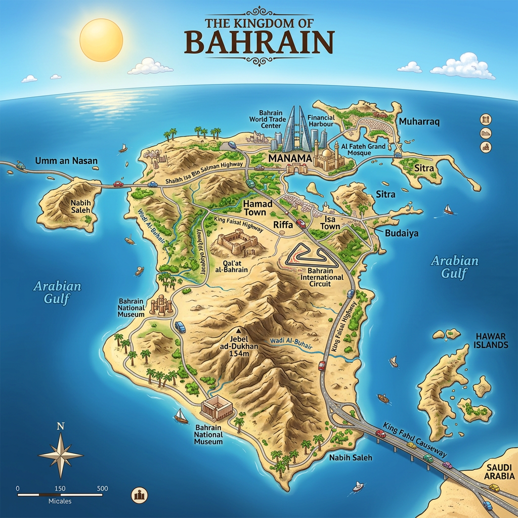
When one thinks of the Middle East, Bahrain is not always the first destination that comes to mind. Yet, this archipelago is full of natural, historical, and cultural riches. Navigating this universe inevitably involves the use of different maps: whether it is a geographical map to locate this country in the heart of the Persian Gulf or a road map to plan travel between the main cities, each version offers a new understanding of the Bahraini territory.
Taking the time to examine these cartographic documents not only allows for organizing a stay on site but also to situate this small kingdom in relation to its better-known neighbors. Discovering Bahrain from an aerial or administrative perspective leads to questioning the nature of its islands, the layout of its roads and highways, or the importance of the main urban centers such as Manama or Muharraq.
Discovering the geography of Bahrain
A look at a geographical map of Bahrain quickly reveals a mosaic of islands nestled in the Persian Gulf. Studying these islets, one notices that the main island concentrates the majority of the population, surrounded by several smaller islets. The immediate proximity to Saudi Arabia strongly influences the country’s configuration, notably in terms of road infrastructure.
The absence of marked relief distinguishes Bahrain from many other countries in the region, making travel easy. The shallow waters bordering certain areas also explain the presence of sandbanks visible on some physical maps. This peculiarity offers delicate landscapes, where the water sometimes seems to subtly blend with the land.
What characteristics distinguish a physical map of Bahrain?
A physical map goes far beyond simple lines defining borders. For Bahrain, it highlights the general aridity, the predominance of sandy areas, and the rarity of vegetation outside of oases. Consulting this type of map, one observes a few isolated heights, such as Djebel ad Dukhan, the country’s highest point, which barely exceeds 130 meters.
One clearly perceives the dominance of the desert climate, materialized by vast beige or ochre patches. The absence of large watercourses makes hydraulic infrastructures essential to the daily lives of the inhabitants. Finally, the strategic position of the coasts on the Persian Gulf appears obvious on any physical representation of the territory.
What lessons can be drawn from an administrative map?
The administrative map presents the different territorial divisions of Bahrain, often called governorates. Each commercial zone, residential sector, or traditional neighborhood is listed there with precision. Such a visual facilitates the identification of local competences, whether in health, education, or security.
Visualizing this organization also makes it easier to understand the concentration of services around the capital, Manama. Conversely, some more rural parts are less densely equipped with administrations or logistical centers. This is directly reflected in the land planning and daily management of the archipelago.
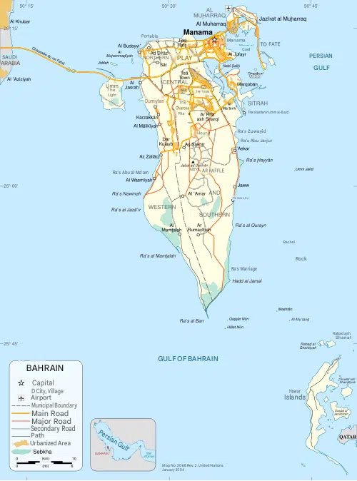
Road and tourist maps of Bahrain: Allies for traveling
Traveling in this kingdom requires skillfully juggling between a road map and a tourist map. One is mainly used for navigating major routes, while the other invites you to discover points of interest, monuments, and unique events scattered between cities. Thanks to them, moving between Muharraq, Riffa, and Manama becomes simple, even for a first visit.
Also, each map is adapted to a particular use. Some are optimized for driving, others favor urban walking or discovering the local cultural heritage. Understanding these nuances maximizes the chances of having a smooth and enriching experience during the stay.
What information can be found on a Bahrain road map?
A good road map shows the main roads and highways connecting the major cities and serving industrial zones, ports, and strategic economic hubs of the archipelago. Routes to the international airport as well as access to the King Fahd Causeway, which links Bahrain to Saudi Arabia, are systematically included.
These maps also highlight secondary roads leading to heritage sites, fishing villages, or beaches favored by locals. The scale used varies according to needs: global map to optimize intercity travel, detailed map to navigate the capital or explore residential suburbs.
What does a tourist map offer to discover Bahrain differently?
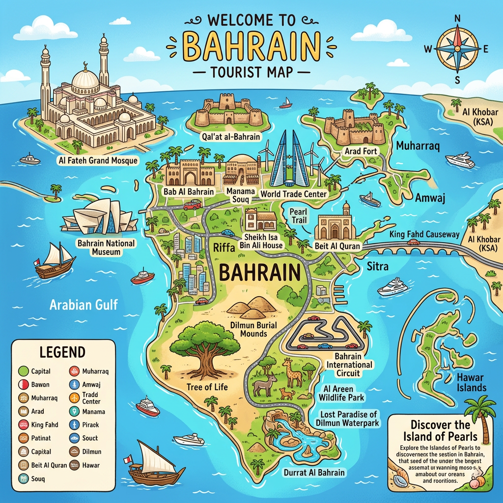
A tourist map focuses on the main cultural attractions, museums, lively souks, and iconic natural places of Bahrain. Through it, it becomes easy to locate the Al Fateh Mosque, Bahrain Fort, or the sports facilities that give the kingdom its international reputation.
Many editions offer walking routes, thematic circuits, or getaway suggestions, particularly suited for those wishing to explore Manama’s historic center without getting lost. Pedestrian zones, green spaces, and traditional markets are always highlighted to enrich the traveler’s journey.
Cities, roads, and highways: Reading urban and regional dynamics
Examining the distribution of cities on a map provides new insight into the country’s development. The capital, Manama, clearly dominates the political, economic, and cultural scene. Around it revolve several other hubs like Muharraq, Riffa, and Hamad Town, themselves connected by a dense network of roads and highways.
This organization is explained by rapid urbanization over several decades, which has led to the creation of new neighborhoods and infrastructures to meet population growth. Mapping the layout of these roadways provides essential clues about how modernity shapes Bahrain today.
- Manama: financial and commercial heart, also the seat of government.
- Muharraq: formerly the capital, known for its architectural heritage and typical markets.
- Riffa: divided into two parts (East and West), a mix of tradition and modernity.
- Hamad Town: recent urbanization, sought after for the quality of its infrastructure.
- Sitra and Isa Town: oriented towards industry or administration, each with distinct characteristics.
The network of roads and highways ensures fairly smooth traffic despite the small size of the territory. Some fast routes allow crossing the archipelago from east to west in very little time, opening new perspectives for work or leisure.
Focus on the situation of Bahrain in the Persian Gulf
On any geographical map, Bahrain appears as a string of islands nestled between the eastern shore of Saudi Arabia and the southwestern coast of Iran. The Persian Gulf gives it a direct involvement in regional trade exchanges, while also accentuating environmental fragility due to the possible rise in sea levels.
Incorporating the maritime dimension into cartographic analysis provides a complete view of Bahrain‘s strategic role. Its multifunctional port, refineries, and energy facilities almost all rely on easy access to major maritime routes.
What impact does the island environment have on the local economy?
The sea surrounds the country and heavily influences commercial activities: import-export of manufactured goods, oil distribution, and the dynamism of the tourism sector. On an administrative map as well as on a tourist map, port facilities are almost mandatory passage points to understand the daily rhythm of the archipelago.
This context explains the impressive sophistication of maritime, air, and land transport infrastructures. Having an overview of these networks via a good map multiplies the opportunities for efficient travel and immersive exploration.
Why are maritime borders so interesting?
No classic land borders exist in Bahrain: its entire perimeter depends on the Persian Gulf. This characteristic generates many bilateral agreements for the exploitation of underwater resources. Some past conflicts actually originated from the precise delimitation of territorial waters, giving a particular significance to the usual consultation of geographical maps.
Knowing the exact contours of the archipelago helps better understand its diplomacy, environmental issues, or the protection of its marine biodiversity reserves. This greatly influences the actions of public administrations and the sustainable management of the coastline.
Effectively using different maps of Bahrain to prepare your stay
Before departure, choosing the right map – geographical, administrative, tourist, or road – makes all the difference! Each meets a specific need. A geographical map laid on the table situates the origin of the trip in the regional space, while a physical map anticipates possible natural constraints.
For those fascinated by history, the administrative map sheds light on the kingdom’s complex past, the evolution of its internal borders, and the dynamics of its cities. Finally, the road map combines modern efficiency and speed, while the tourist map feeds the wonder and curiosity of those wanting to grasp all the nuances of this gem of the Persian Gulf.
- Locate the real distances between major cities
- Quickly identify access routes to tourist sites
- Plan breaks in amazing natural spaces
- Organize according to the particularities of the arid climate
- Distinguish urban areas from agricultural or desert spaces
Digital technology today facilitates the consultation and sharing of interactive maps, sometimes accessible within seconds on smartphones or tablets. But nothing replaces the added value of a paper medium to take a step back, compare different types of information, or manually note advice on the planned itinerary.
Every visitor would benefit from combining several types of map: all compete in ingenuity to reveal the fascinating diversity of an archipelago that knows how to blend millennia-old history and contemporary challenges.
FAQ – Bahrain map: Practical information and country overview
Bahrain is an island country located in the Persian Gulf in the Middle East. It is connected to Saudi Arabia by the King Fahd Causeway and is located near Qatar.
The capital of Bahrain is Manama, which is also the country’s largest city. It serves as the archipelago’s main political, economic, and financial center.
A map of Bahrain helps locate the main islands, major cities, roads, and coastal areas. It also provides a better understanding of the archipelago’s geography and its location in the Persian Gulf.
