
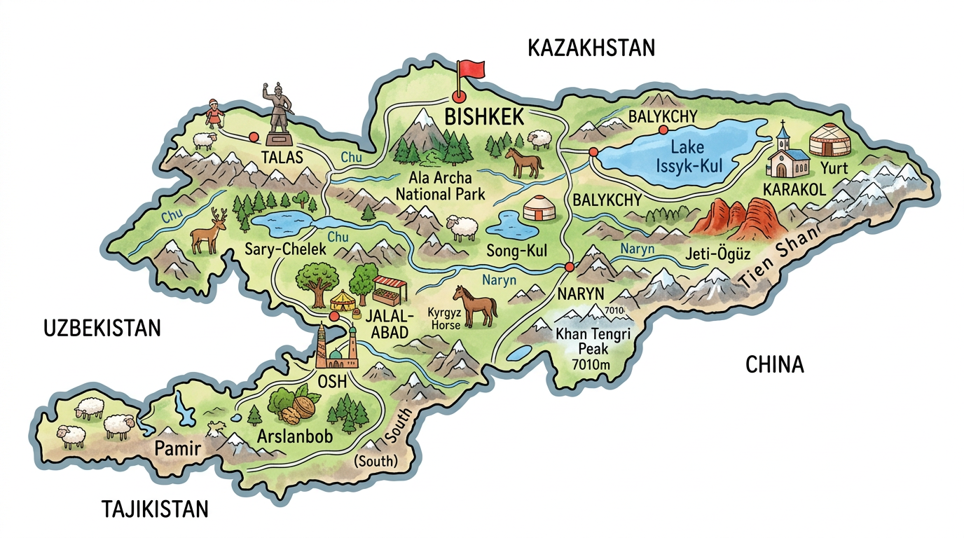
Exploring Kyrgyzstan through its geographical maps is to offer oneself a true journey among majestic mountains, peaceful valleys, and nomadic cultures. Even before packing a suitcase or planning an itinerary, studying the various available maps allows for better anticipation of distances, terrains, and the diversity that characterizes this country at the heart of Central Asia. Whether one is looking for a road map to plan a route or a detailed city map, each medium presents valuable information. Here is a comprehensive guide to deciphering the diversity of Kyrgyzstan’s maps, from its major borders to the intimacy of its small towns.
Why consult a map of Kyrgyzstan before traveling?
The first handling of a map of Kyrgyzstan already offers a striking overview of its natural heritage. More than simple road layouts or political boundaries, these documents abound with details about the mountain structure, population distribution, and the location of major cities. Careful reading of a geographical map quickly reveals why this country attracts so many adventure and hiking enthusiasts.
For a curious traveler, taking the time to understand a tourist map or a city plan can make the difference between an improvised stay and a more structured exploration. Preparing stages, choosing points of interest, and anticipating challenges related to the terrain then become much simpler. The notable differences between a topographic map, a road map, or a simple plan allow adapting one’s approach according to one’s desires.
Types of maps to explore Kyrgyzstan
Everyone will need a different type of map depending on their project, whether it is exploring the capital or going on a trek in the mountains. Discover below the options one might encounter during their research.
The geographical map to locate the country
The geographical map remains the ideal starting point to orient oneself in space. On this type of document, one can easily visualize Kyrgyzstan’s position in Central Asia, surrounded by China, Kazakhstan, Uzbekistan, and Tajikistan. The borders are highlighted here, as well as the major natural formations such as the mountain ranges, true backbones of the country.
One also notes the notable presence of lake expanses such as the immense Issyk-Kul, often spotted at the top right of a map. The names of the main rivers also appear, helping to familiarize oneself with the complex geography of this landlocked region far from the seas but dominated by water from glaciers.
The road map to prepare one’s journey
The road map will interest those ready to travel the country by car, bike, or even hitchhiking. Unlike some densely served regions, the road network in Kyrgyzstan sometimes tests the patience and improvisation skills of travelers. A good road map will not only identify the main routes but also provide information on road conditions, the presence of difficult mountain passes, or the scarcity of gas stations.
Thus, the routes connecting Bishkek, Osh, or Karakol are generally well indicated, as are some secondary routes leading to lesser-known villages or cultural sites. To avoid any unpleasant surprises, one should never underestimate the usefulness of an updated map when crossing mountainous or rural areas.
The tourist map to spot the must-sees
The tourist map often combines several useful elements: it indicates key monuments, nature reserves, some recommended accommodations, and nearby outdoor activities. From the archaeological site of Burana to Ala Archa National Park, this colorful map makes tangible the many possibilities offered to visitors.
This facilitates prioritizing, by visualizing at a glance the lively neighborhoods, preserved natural spaces, and festive places not to be missed. Illustrations often lighten its reading while drawing attention to treasures sometimes absent from classic guides.
The city map, essential for strolling
In major urban areas like Bishkek or Osh, the city map quickly becomes indispensable. It precisely details the streets, bus or shared taxi (marshrutka) stops, markets, and museums. Rather than wandering blindly, it is better to study the layout of administrative buildings, public gardens, or shopping districts. This greatly simplifies daily travel.
With such a tool, preparing a visit to the central bazaar or finding a traditional restaurant takes less time. Some bilingual or trilingual versions also ensure quick understanding, even for those less familiar with Russian or Kyrgyz, languages commonly used locally.
The topographic map for mountain enthusiasts
Those who aim to climb high peaks or hike through remote valleys unhesitatingly prefer the topographic map. It highlights, thanks to its contour lines and symbols, the features of the relief. Every ridge, every glacial valley is identifiable, and one quickly visualizes areas requiring increased vigilance or specific physical preparation.
From the Tian Shan massif to the Pamir Alay, this type of map reveals the power of Kyrgyz nature. Using such a resource ensures increased safety during off-trail hikes, notably thanks to the precise identification of temporary shelters or potentially dangerous passages at high altitude.
Close-up on the geography and borders of Kyrgyzstan
A careful observation of a map of Kyrgyzstan constantly reminds one of the uniqueness of its borders and its relief. This country has no access to the sea but more than compensates for this absence with impressive geographical diversity. The eye is quickly drawn to the rocky massifs, omnipresent even on the most simplified representations.
The borders shared with China, Kazakhstan, Uzbekistan, and Tajikistan divide the country into sectors sometimes sparsely populated, or even uninhabited over large mountainous areas. Traveling from one end to the other therefore requires anticipation and flexibility, especially in peripheral regions far from major urban centers.
The mountains and relief in detail
A topographic map of Kyrgyzstan always surprises with the verticality of its landscape. More than eighty percent of the territory lies above 1,500 meters in altitude. Studying such a map accentuates the sense of dominance of the Tian Shan ranges in the north and the Pamir Alay in the south.
Among the emblematic peaks, Peak Pobedy and Khan Tengri, both over seven thousand meters, symbolize this rugged character. The steep foothills give rise to deep valleys where pastoral traditions persist and where one more often encounters yurts than modern dwellings. Reading a geographical or topographic map therefore allows better anticipation of climatic or terrain constraints.
Population, ethnicities, and major cities through maps
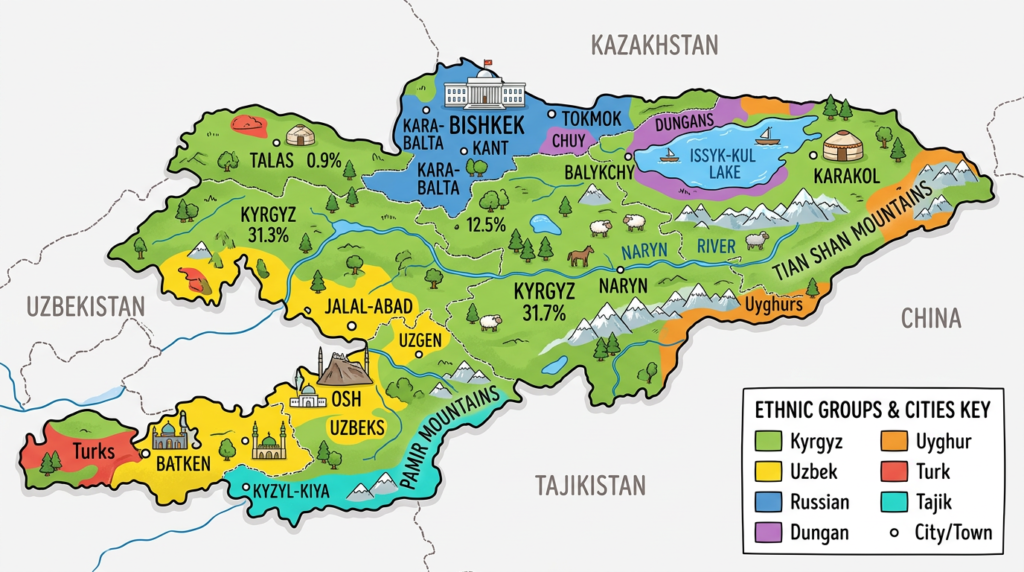
The analysis of a demographic map usefully complements the traditional morphological perspective. Although sparsely populated relative to its area, Kyrgyzstan stands out for its great ethnic diversity. Illustrative maps often highlight the concentration of inhabitants around a few fertile basins or along major transportation routes.
Several maps offer a visual differentiation of ethnic groups, thus revealing the intricate network among Kyrgyz, Russian-speaking, Uzbek, Tajik, and Uyghur populations. These distinctions provide valuable insight into social dynamics, especially in border provinces where multiple communities coexist.
- Bishkek: the capital, the political, economic, and cultural heart, located in the Chu River basin near the Kazakh border.
- Osh: an important city in the south, a crossroads of historical exchanges on the Silk Road.
- Karakol: the main gateway to access Lake Issyk-Kul and the surrounding treks.
- Jalal-Abad and Talas: other urban centers contributing to the diversity of the Kyrgyz fabric.
An adapted city map for each of these localities helps distinguish traditional residential areas from districts with distinct architectures, reflecting their cultural pluralism.
Choosing the right map according to your discovery needs
Given the variety of available formats, the question often arises: which map should be prioritized for which project? Hikers, urban travelers, or adventurers of secondary roads will each find a format that matches their specific expectations.
For a road trip in central asia
Planning a trip of a week or more necessarily involves analyzing a comprehensive road map, possibly combined with main city maps. This duo avoids many surprises by facilitating distance management and the search for fuel or services sometimes scarce outside major urban areas.
Sometimes specialized atlases are added, complementing with advice on the seasonal condition of roads or legislation specific to crossing borders. Anticipating the weather, measuring altitude, or planning route changes are all assets appreciated by cautious drivers.
For hiking and exploration in the great outdoors
An outing in the Tian Shan or the Alatoo mountains naturally requires the use of a detailed, perfectly readable, and up-to-date topographic map. It shows steep slopes, alpine pastures, marked or unmarked routes, as well as essential water points at altitude.
Relatively lightweight and moisture resistance are sought after by adventure enthusiasts, who sometimes complement their equipment with mobile apps offering zoom and GPS precision, while keeping a paper version handy.
To discover city life
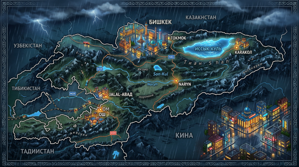
A city map takes center stage here, allowing easy navigation through complex neighborhoods, and easy location of stations or markets. It remains the best ally during gourmet outings or spontaneous cultural visits.
Some urban maps now offer interactive features to overlay heritage data, pedestrian routes, or real-time updated tourist recommendations, enhancing the local immersion experience.
Towards a richer and more intuitive reading of Kyrgyzstan
Taking the time to analyze various maps of Kyrgyzstan allows for a refined understanding of the country, its human realities, and its spectacular landscapes. Road maps, topographic maps, or city plans complement each other to guide curious travelers toward new horizons, between endless steppes, snow-capped peaks, and unexpected cultural blends. Faced with the geographic and social diversity encountered from one valley to another, choosing the right format serves both practical preparation and the pleasure of discovery on the ground. Sometimes, a simple glance at a detailed map is enough to already spark the next travel dreams.
