
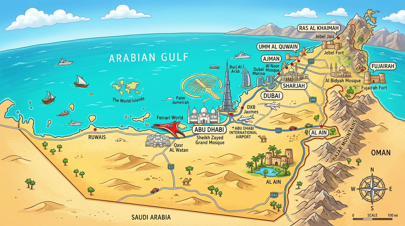
Discovering the United Arab Emirates often awakens curiosity and a desire for exploration. Between deserts, futuristic cities, and golden shores, this country attracts with its geographical and cultural diversity. Using a well-designed map helps to locate points of interest, plan a stay, or simply better understand the region. Through this article, dive into the world of maps dedicated to the United Arab Emirates, exploring their uses, features, and challenges, whether for travel, study, or discovery.
Why consult a map of the United Arab Emirates?
Finding your way within the United Arab Emirates requires more than just a simple modern navigation tool. The perspective offered by a true geographical map allows you to visualize at a glance the relationships between main cities, borders, and emblematic natural areas. It is also a way to grasp the rapid growth of a territory where urban changes are constant.
Whether the goal is professional, touristic, or educational, consulting a map of the United Arab Emirates provides key information: distances, strategic road axes, reliefs, but also the location of airports or remarkable natural sites. This overview becomes essential, both to prepare a trip and to enrich a passion for cartography or geography.
What types of maps can be found for the United Arab Emirates?
Needs vary depending on the context: preparing a trip to the United Arab Emirates, studying urban development, or exploring natural diversity. Several formats of maps have therefore emerged, adapted to different uses.
Some maps meet very specific requirements, while others aim for a more general approach. The choice of the type of map will depend on the preferences or specific questions the user has. Here is an overview of the most common categories that can prove useful during an in-depth search on this region of the world.
Classic geographical maps and base maps
The classic geographical map remains essential to precisely locate the United Arab Emirates in the Middle East, near the Persian Gulf and surrounded by neighbors such as Saudi Arabia or Oman. This medium facilitates the perception of borders and highlights the main geomorphological features, including vast deserts and coastlines.
The base maps are often used for teaching or for creating new thematic maps. They offer stripped-down outlines, allowing for example to mark the main regions, communication routes, or even to draw a blank map on which to annotate personalized information.
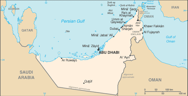
City plans and zooms on urban centers
For those wishing to explore Dubai, Abu Dhabi, or other dynamic metropolises, city plans detail streets, neighborhoods, major attractions, and urban transport. These maps help travelers and residents plan trips and visits while becoming familiar with the structure of each urban area.
The city plans exist in digital and paper form. Their precision varies according to needs: some emphasize tourist infrastructures, others prioritize signage for local businesses or popular hotels.
Tourist maps and simplified visual guides
When it comes to discovering the must-see spots during a trip to the United Arab Emirates, the tourist map takes on full importance. It concentrates monuments, museums, main shopping centers, famous beaches, and sometimes offers recommended routes.
This type of map often combines photos, pictograms, and suggested itineraries, offering easy reading. Visitors quickly identify the main attractions, thus facilitating the design of a balanced circuit through the different main regions of the territory.
Road map, transport networks and connectivity
The connection between the various cities is greatly facilitated thanks to modern infrastructures. Viewing these links on a road map offers the possibility to plan routes, durations, and potential stopover points.
There are also specialized diagrams indicating internal air routes, railway lines where they exist, as well as key stations and stops. These maps allow anticipating travel times and dealing with possible logistical constraints during trips within the country.
Discovering the main cities and emblematic regions
The landscape of the United Arab Emirates reflects great urban and natural diversity. Each thematic map enriches geographical knowledge by focusing on one or another aspect of the country.
A careful overview reveals the dynamism of certain urban areas while other zones highlight preserved nature or lesser-known historical layers.
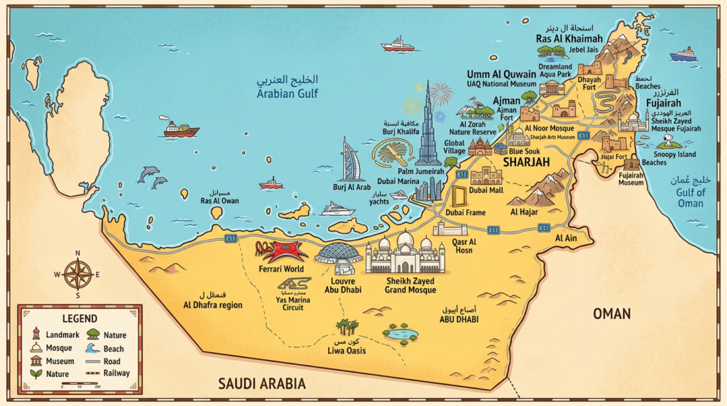
Dubai and Abu Dhabi: economic centers and architectural symbols
Dubai shines with its spectacular skyscrapers, its artificial islands visible from space, and its giant commercial complexes. A good city map reflects this exceptional urban density and its contrasts between old souks and new high-tech districts.
Abu Dhabi, the political capital and seat of government, spreads over several coastal islets. Its plan reveals palaces, remarkable museums, large avenues, and well-maintained beaches. Navigation in this city becomes simpler with an accurate representation of its main roads and cultural hubs.
Sharjah, Ajman and Umm al-Quwain: traditions and heritage
Outside the two heavyweights, Sharjah maintains an identity oriented towards Islamic arts and tradition. The plans of this city reveal a more sober layout but conducive to quiet strolls, far from the bustle typical of Dubai.
Ajman and Umm al-Quwain offer a more relaxed pace, often highlighted on tourist maps by the presence of wild beaches, peaceful lagoons, and authentic markets. These localities represent an opportunity for a different perspective on Gulf civilizations.
Ras Al Khaimah and Fujairah: natural spaces to explore
In the north, Ras Al Khaimah perfectly illustrates the meeting between mountain and ocean. On most maps, one can easily perceive imposing mountain ranges descending to the sea, ideal for hiking and water sports enthusiasts.
Fujairah borders the eastern coast and stands as an essential anchor point for those seeking to observe marine life or discover traditional villages. Special mention to topographic maps which reflect the variety of relief and ecosystems in the region.
How to effectively use maps to plan a stay in the United Arab Emirates?
Preparing a trip to the United Arab Emirates takes on a new dimension when fully exploiting the richness of a map adapted to one’s needs. Identifying must-see stops, calculating optimized routes, and anticipating regional particularities help make the experience smooth.
To go further, it can be useful to combine several sources: the road map, the blank base map for personal annotations, or even city plans combined with interactive applications. From this combination arises a global and personalized vision of the upcoming expedition.
- Consulting a tourist map immediately highlights the distances to be covered between the main cities.
- A plan of the United Arab Emirates facilitates the distribution of activities by zone: shopping in Dubai, desert exploration near Abu Dhabi, seaside leisure in Ajman.
- The combined use of base maps and detailed plans allows personalizing one’s itinerary by noting places of interest or unusual restaurants.
- Finally, so-called blank maps promote educational games and learning, ideal for introducing children or teenagers to local geography.
In summary, centralizing all these graphical representations structures the organization of a trip and allows the discovery of little-known aspects of the country, often absent from initial traditional research.
Maps have continuously evolved to adapt to varied expectations, from the casual visitor to the regional history enthusiast. Do not hesitate to look for different models: each map brings its own touch of information, thus refreshing the vision of the country with each new consultation.
Where to find a quality map of the United Arab Emirates?
Access to precise and updated materials is no longer difficult in the digital age. Resources abound, from specialized portals to printed atlases, including interactive versions accessible online or via mobile applications.
In a school setting, the use of a blank map is common for working on toponymy or the evolution of borders. For a tourist stay, a printed version remains practical, slipped into a pocket or backpack, thus avoiding constant dependence on an internet connection. Professionals, for their part, opt for base maps ready to annotate or integrate into various reports.
Choosing your map well ultimately means paying as much attention to the format (paper, digital) as to the content: always check for the presence of the latest data, especially regarding recent infrastructures or new developments in major urban centers.
Whatever the selected source, take advantage of the current diversity of representations: the multiple levels of detail adapt to all projects. Tourist maps, contemporary city plans, or simple technical base maps, everyone will find the perfect fit.
The central role of the map in discovering the United Arab Emirates
The practice of cartography opens up a thousand and one perspectives as soon as one wishes to unravel the mystery of a rapidly growing country. For the traveler, the map serves as a compass; for the teacher, it catalyzes the understanding of contemporary issues; for the discovery enthusiast, it fuels the desire to deepen knowledge of each territory.
Faced with the mosaic of territories composing the United Arab Emirates, no visit or study can be complete without giving a place of honor to the map in all its forms. This tool helps reveal the unique dynamic of the country: a fusion of tradition and modernity, a marriage of desert and sea, the vibrancy of megacities contrasted with the serenity of rural areas.
Ultimately, keeping a map at hand invites rediscovery, at every moment, of the unsuspected richness of this region resolutely looking towards the future, while preserving its deep roots.
