
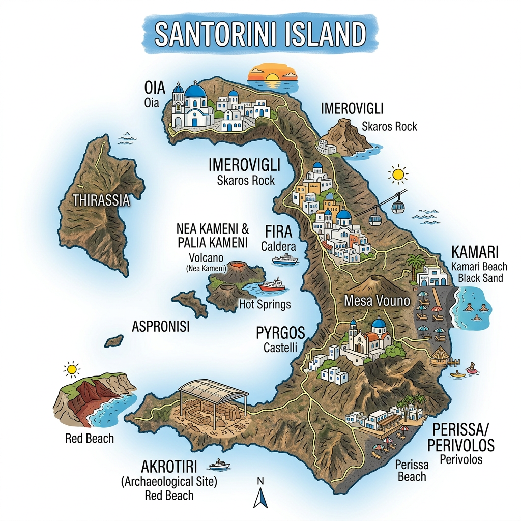
It is impossible to talk about the archipelago of the Cyclades without mentioning Santorini. This Greek island attracts travelers from all over the world thanks to its impressive landscapes and unique atmosphere. When it comes time to organize a trip to this destination, having a good geographical map in front of you quickly becomes essential. Whether you choose a paper map, a mobile app, or an interactive online version, understanding the layout of Santorini can transform your tourist experience. This guide dives into the heart of the emblematic towns and villages, presents the main roads, reveals the secrets of the volcanic caldera, and offers tips to fully enjoy the must-see sites.
Why use a map of Santorini during a trip?
Finding your way on a geographical map of Santorini is not only useful to avoid getting lost. It is above all a way to better prepare your movements and not miss any of the local wonders. Indeed, the island has a unique configuration linked to its volcanic formation, which strongly influences the orientation of the main roads and the location of the main points of interest.
Careful preparation with a Santorini map also facilitates the discovery of hidden beaches, suitable hotels, or hiking trails along the volcanic caldera. It also allows you to prioritize visits according to your desires and available time, reducing unforeseen issues related to transport or distances to cover.
Understanding the geography of Santorini
Even before detailing a map of the Greek island, it is appropriate to place Santorini in the broader context of the Cyclades archipelago. Deeply marked by a tumultuous past, its exceptional profile results from the collapse of an ancient volcano, which explains the presence of the famous crescent of land surrounding the sea.
This spectacular relief sculpts not only the panoramas but also the organization of the towns and villages. Access to certain areas therefore requires particular attention when preparing a tourist itinerary.
Where are the main villages located?
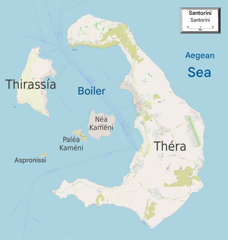
Santorini aligns its emblematic villages along the volcanic caldera. Oia, at the very north, enjoys worldwide popularity thanks to its spectacular sunsets and its whitewashed houses. Further south, the capital Fira extends majestically on the cliff, offering breathtaking views of the Aegean Sea.
Between these two poles, Imerovigli and Firostefani each offer their charm, while inland, Pyrgos captivates with its authentic atmosphere and cobbled streets. A precise map helps visualize how to connect these villages without unnecessary detours.
How are the main roads and secondary routes organized?
A glance at the Santorini map reveals two structuring main roads. The first, running along the caldera from north to south, connects Fira to Oia and crosses superb natural viewpoints. The other crosses the island from west to east, linking the tourist capitals to the black sand beaches, such as Kamari and Perissa.
Secondary paths wind through vineyards and tomato fields, inviting discovery off the beaten track. Favoring a car or a quad therefore requires careful anticipation of your route, including finding the best parking spots near the must-see sites.
Practical details: reading and using a map of Santorini
On a daily basis, navigating Santorini requires some tips to effectively read a geographical map. The changes in elevation, typical of this Greek island, significantly impact travel times. A distance of three kilometers can sometimes take thirty minutes if the slope or terrain configuration is steep.
Each locality has its particularities and it can be useful to have access to several types of maps, depending on whether you want to discover secret beaches, reach lively neighborhoods, or dive into the history of the volcanic caldera.
Which tools should be favored for easy navigation?
- Mobile applications offering geolocation and pedestrian routes
- Paper maps distributed in most hotels or tourist offices
- Interactive maps accessible before departure to organize each day
Everyone can choose the most suitable medium, knowing that some beaches or main roads remain poorly served by mobile networks. Having an offline map is still wise to move freely even far from the most well-known towns and villages.
Spotting local emblems directly on the map — such as the windmills of Oia, the museums of Fira, or the perched chapels — offers an inspiring overview to organize your route between cultural discoveries and swimming breaks.
How to include hiking trails and boat excursions?
Many discover the beauty of Santorini in ways other than by car. Several trails connect the major villages on the heights of the volcanic caldera. For example, the Fira-Oia footpath winds between steep cliffs and unique viewpoints over the archipelago.
The specialized maps often include these walking routes and indicate average walking times. To explore the neighboring islets, there are also nautical charts detailing boat routes to Thirasia or Nea Kameni, famous for its hot springs fed by volcanic activity.
Discover beaches and natural attractions thanks to a detailed map
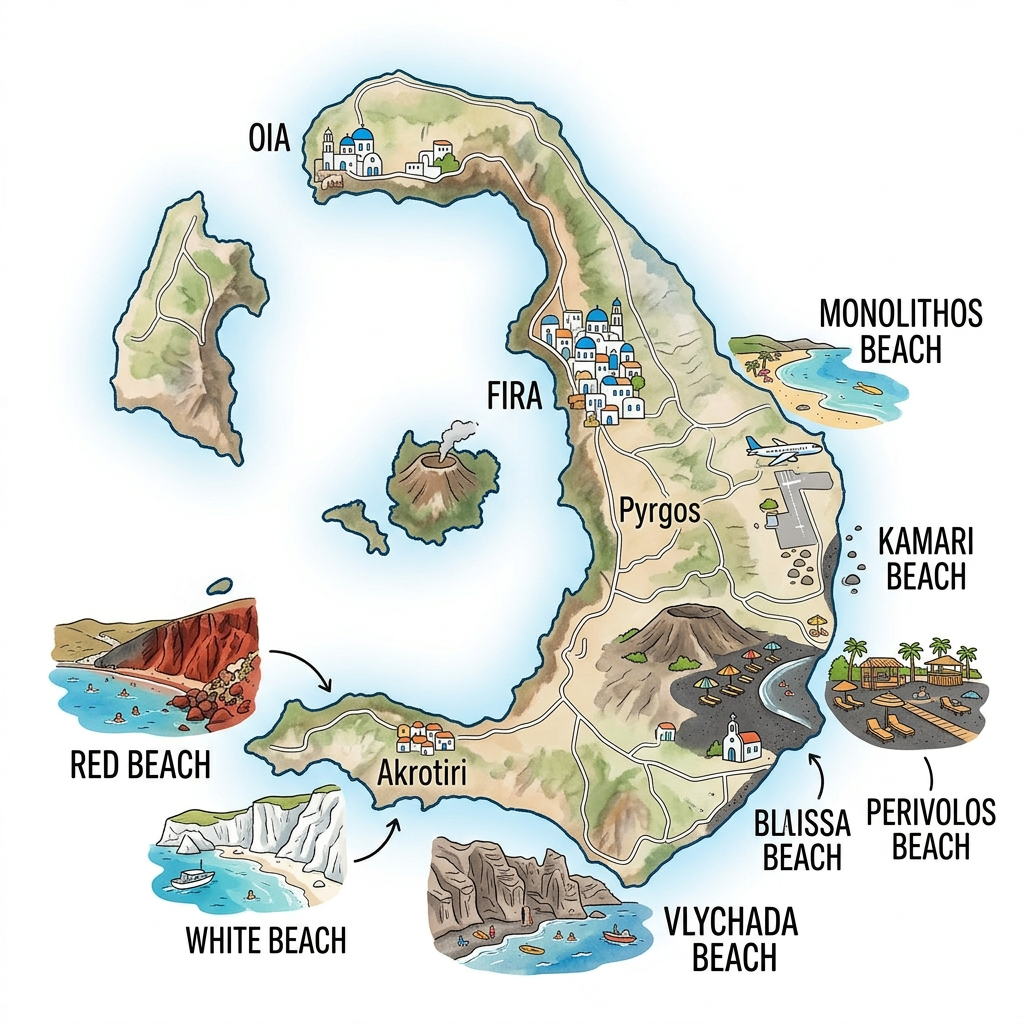
Santorini is full of varied beaches, many of which appear on the geographical map as small symbols or specific names. Some benefit from full tourist facilities, others remain more secluded for those seeking tranquility.
Most of these bathing areas are located on the east and south coasts, away from the villages perched on the volcanic caldera. A Santorini map helps select must-see sites based on their features: services, dark sand, red pebbles, or snorkeling spots.
Which beaches should not be missed?
Among the renowned beaches are Perissa and Kamari, vast volcanic sand areas lined with bars and restaurants. The famous Red Beach attracts with its ochre hues and steep cliff, while White Beach offers a quieter alternative close to the ancient site of Akrotiri.
Some visitors prefer to explore Vlychada or Monolithos, where the crowds lessen and the atmosphere remains wilder. The choice will depend on the type of stay sought and the desired comfort, each beach having access points detailed on many maps available locally.
How to combine swimming, culture, and volcano observation?
The magic of Santorini lies in the variety of activities accessible in a single day. After a morning with your feet in the water, why not climb to the highest point of the village of Imerovigli to admire the panorama over the volcanic caldera?
In the evening, visiting a museum in Fira or one of the prestigious wineries, all featured in the region’s illustrated tourist catalogs, will give another dimension to the stay. A well-used Santorini map avoids wasting precious time hesitating about the next stop.
Must-see sites to locate on a map of Santorini
Even without a fixed itinerary, certain places consistently appear on tourist maps and are worth taking the time to identify in advance. They bear witness to the millennia-old history of the archipelago as well as the geological uniqueness of this Greek island.
Here is a selection of these must-see sites to identify on any good map of Santorini:
- The town of Oia and its viewpoints over the volcanic caldera
- The archaeological site of Akrotiri, a remnant of an ancient civilization
- Fira, the lively epicenter of Santorini tourism
- The old port of Amoudi, ideal for tasting local specialties
- The traditional vineyards and wine cellars, scattered on the heights
- The Orthodox church Panagia Platsani, a marked architectural symbol
- The beaches to the south and east, essential spots to vary the pleasures
Identifying the exact location of these must-see sites greatly simplifies daily logistics, especially during periods of high tourist influx. Some are better served than others, and the choice of transportation mode or accommodation may depend on this.
Santorini map: final tips for preparing your stay
Having a reliable geographical map remains the first step before any immersion in Santorini. Digital and paper solutions coexist harmoniously and cover all types of travelers, from independent explorers to families seeking reassuring landmarks.
To enrich the experience, it is recommended to personalize your map of Santorini according to your interests: gastronomy, local history, photography, beach relaxation, or exploration of the main roads and hiking trails. With proper organization, every corner of this Greek island holds its share of surprises, always within reach thanks to a good map.
FAQ-Santorini map
Santorini is an island located in the southern Aegean Sea, within the Cyclades archipelago. A map makes it easy to identify its location in relation to Athens, Crete, and the other Greek islands.
A map of Santorini highlights the main towns such as Fira, Oia, and Kamari, as well as the roads and major tourist attractions. It also helps visitors locate the beaches, the caldera, and the island’s ports.
Looking at a map helps you plan your trips and decide which places to explore. It also makes it easier to prepare your itinerary and save time during your stay.
