
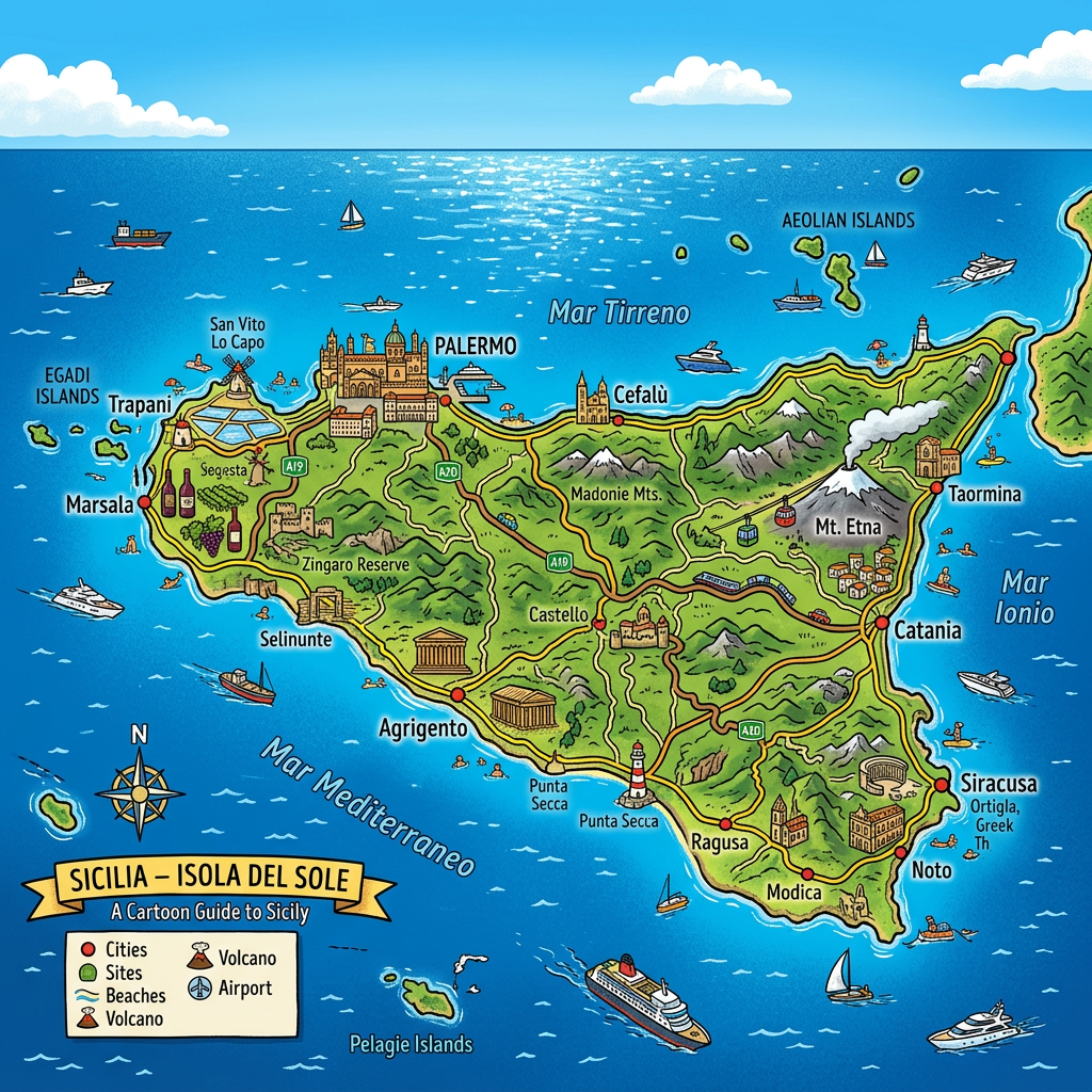
Sicily, this large Italian island situated in the heart of the Mediterranean, has captivated for centuries with its cultural richness, varied landscapes, and timeless charm. Whether preparing for a first trip or deepening a visit, taking an interest in the map of Sicily quickly becomes essential. Between the general map, tourist map, road map, or detailed plans of main cities such as Palermo, Catania, and Agrigento, each medium offers a different perspective of the territory and facilitates the discovery of authentic itineraries. Let’s look at the advantages of the different maps, the regions of Sicily to know, as well as the highlights of the geography and history of Sicily.
Why consult a map of Sicily?
Exploring Sicily without a precise map is somewhat like setting off on an expedition without a compass. The island is much larger than one might imagine, with a complex topography and sometimes deceptive distances for first-time visitors. Thanks to a map of Sicily, it becomes much easier to orient oneself, identify the major tourist sites, and create tailor-made itineraries, whether visiting for a week or longer.
Trips to Sicily are often punctuated by unexpected discoveries off the beaten path. Using a tourist map or choosing a specific map of Sicily based on interests not only optimizes time but also allows enjoyment of the seaside, perched villages, and inland countryside, all without missing the must-see spots.
Overview of sicilian geography
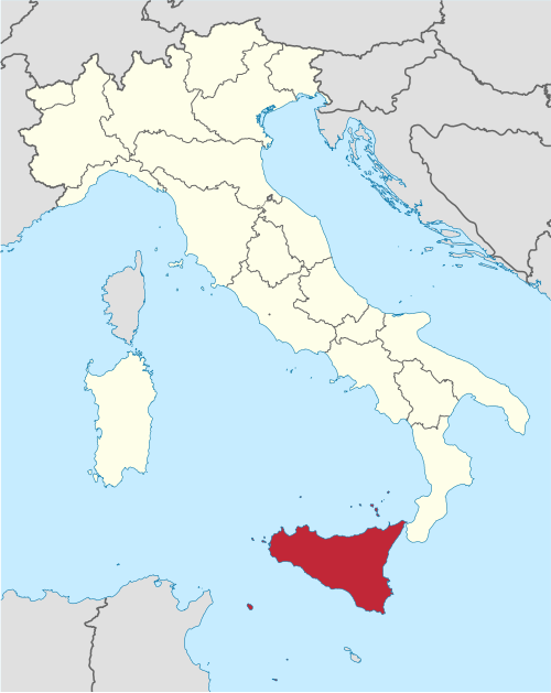
When looking at a map of Sicily, one quickly notices the island’s distinctive triangular shape. Located between the tip of Italy’s Calabria and the African coasts, Sicily sits at the crossroads of Mediterranean influences. This particular geographical position has shaped its relief and climates, ranging from golden beaches to the snowy peaks of Etna.
The geography of the region highlights some striking contrasts. Agricultural lands of the plains border the imposing mountains of the Madonie or the Nebrodi, while the coastal strip alternates between steep cliffs and long fine sandy beaches. On the road map, this diversity entails some peculiarities to anticipate when traveling between the various regions of Sicily.
Main mountain ranges and volcanoes
The island has several mountain ranges, such as the Peloritani in the northeast or the Iblei in the south. But the undisputed star remains Etna, an active volcano often visible on tourist maps, which dominates the province of Catania and attracts hikers as well as lovers of supernatural landscapes.
Beyond Etna, the small scattered volcanoes on the Aeolian Islands also deserve a visit on a specific map of Sicily for those seeking unusual experiences close to the main island.
Coasts and surrounding archipelagos
It is impossible to talk about the map of Sicily without mentioning its rugged coasts and small satellite islands. Egadi, Pantelleria, or Ustica – each appears on the best maps of Sicily to extend one’s journey beyond the Sicilian mainland.
These places offer an additional glimpse of the region’s natural diversity. For planning boat trips or beach stops, referring to a precise tourist map can prove very useful.
Focus on the major cities and their importance
Any visit to Sicily necessarily includes exploring some of its main cities. Each has its own personality and holds a central place on every map of Sicily, both for its historical value and its current dynamism.
From Palermo, the vibrant regional capital, to baroque Catania, not forgetting Agrigento and its famous Valley of the Temples, the Sicilian metropolises form the main framework of a successful stay.
Palermo at the crossroads of civilizations
Palermo, the largest city in Sicily, stretches along the northern coast and can be easily identified on any map of Sicily. Its port, lively markets, and narrow streets blend Arab, Norman, and Baroque influences into a unique kaleidoscope.
Having a detailed map of Palermo greatly helps to navigate efficiently through the bustling historic center, where monuments, palaces, and museums compete for attention. The city’s gardens, popular neighborhoods, and colorful buildings form a true urban treasure.
Catania and the protective shadow of etna
Heading east with Catania, the island’s second-largest urban area and the main access point for climbing Etna. On a road map, Catania appears as the hub of routes leading to the seaside resorts of the Ionian coast or the latest volcanic flows of the nearby massif.
A good map of Catania or its surroundings also reveals the abundance of Baroque sites, ancient churches, and charming small ports. The contrast between millennial heritage and modern vibrancy is one of the city’s main strengths.
Agrigento and the Valley of the Temples
Agrigento, for its part, shines in the west for its remarkable ancient ruins. On a tourist map, the “Valley of the Temples” always holds a prominent place, as it represents the architectural pinnacle of ancient Greece on Sicilian soil.
A detailed map of Sicily helps to understand how Agrigento is structured around these majestic ruins, with the old town perched above and the sea nearby. Visiting this area always means traveling between history and spectacular nature.
How to read and use a map of Sicily effectively
Having a map of Sicily in hand is already a dive into the island’s thousand faces. However, not all maps are equal, and it is important to choose the right tool for each stage of the trip. A few tips allow you to make the most of this essential tool:
- Identify in advance the regions of Sicily that arouse the most interest: coastal zone, fertile valley, central mountain…
- Use an interactive or paper map of Sicily showing the main road axes, especially to optimize routes between two distant cities.
- Look for specialized tourist maps of natural sites (reserves, national parks) when planning hiking or observing particular landscapes.
- Rely on city center maps (Palermo, Catania, Syracuse) to simplify walking tours and include local gastronomic stops.
- For itineraries off the beaten path, diversify sources: detailed road map, GPS app, local documentation at the tourist office or accommodations.
This diversity of approaches ensures true freedom in designing a personalized route, through spectacular roads, wine routes, or small winding departmental roads connecting secret villages and wild landscapes.
Itineraries and suggestions to discover Sicily
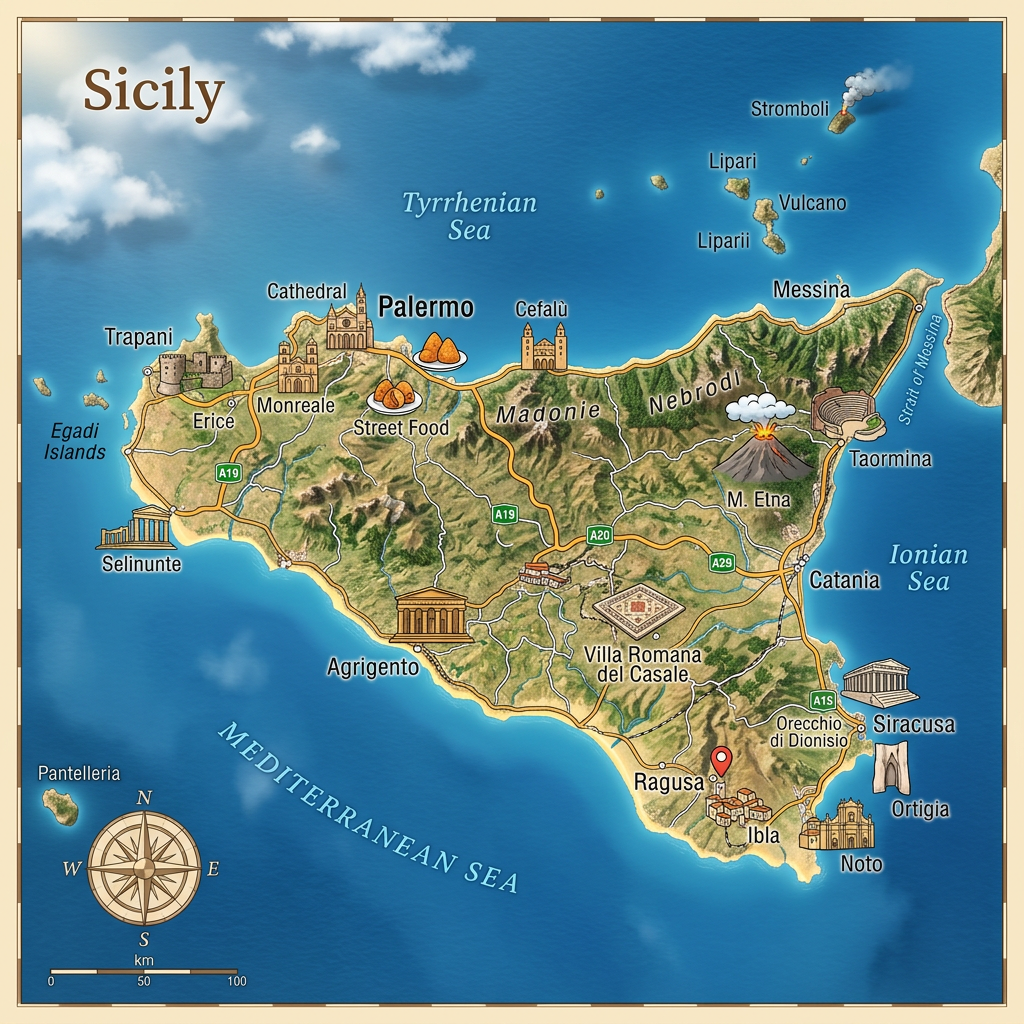
Thanks to a good knowledge of existing maps of Sicily, organizing balanced itineraries combining city, culture, nature, and relaxation quickly becomes an exciting game. Several classic routes regularly appear in guides and among seasoned travelers.
Some prefer a circular itinerary, others choose a linear circuit to avoid detours, each adapting the duration and stops according to their desires and the regions of Sicily explored.
Cultural road trip on the north coast and inland
A classic itinerary starts with Palermo, then follows the northern coast to Cefalù, then crosses inland via Enna before descending to Agrigento and the famous Valley of the Temples. A good map of Sicily highlights possible stops such as Monreale, famous for its cathedral, or Piazza Armerina known for its Roman mosaics.
This route allows combining medieval architecture, family beaches, and immersion in the history of Sicily.
Discovering baroque splendors and mount etna
The east of the island invites one to combine the urban dynamism of Catania with the discovery of the Baroque towns listed as UNESCO World Heritage sites: Ragusa, Noto, Modica. These gems appear on most tourist maps, so rich and spectacular is their heritage.
Continuing towards Taormina, perched facing the sea and at the foot of Etna, perfectly completes the route of grand panoramas. All this while taking picturesque routes revealed by an up-to-date road map.
Summary of a successful stay thanks to suitable maps
Whether mapping out one’s own itineraries or letting oneself be surprised by local suggestions, the map of Sicily remains the unrivaled ally of the curious traveler. Combining the precision of the plan with the flexibility of desires gives birth to unforgettable memories.
Choosing the right document, knowing how to read distances, anticipating the geographical particularities of the region, and paying attention to the history that shines through in every place name enhance the experience on the road. Thus, each stop gains more meaning and intensity.
History and Evolution of Maps in Sicily
Already in Antiquity, Greek and Phoenician navigators used schematic representations of the region to connect ports and sheltered bays. Over time, the map of Sicily has followed the developments of sciences, integrating new topographical and historical data over the centuries.
The Norman and then Spanish periods strongly influenced how internal borders, communication routes, and even the naming of main cities were drawn. Today, the diversity of mentioned supports (road map, tourist plan, thematic diagrams) reflects the contemporary vitality of a territory attached to its multiple identity.
The impact of history on the current diversity of maps
Besides political and territorial changes, natural upheavals have also played a decisive role. Tourist maps often highlight traces left by earthquakes, lava flows, or certain human transformations from prosperous eras.
It is this layering of history and geography that fascinates and guides, even today, step by step, every traveler equipped with their map of Sicily, whether ancient or digital.
New trends: from digital to interactive apps
With the proliferation of mobile applications, the map of Sicily is no longer limited to paper format alone. Users now benefit from GPS, real-time information, and personalized filters to adjust their itineraries according to local contingencies, seasonal festivals, train schedules, or culinary recommendations.
These innovations meet a contemporary need: gaining autonomy while keeping track of favorites or unexpected discoveries, thus facilitating every journey and enhancing immersion in Sicilian magic.
Perspectives for better enjoying Sicily with a map in hand
Armed with a carefully chosen plan of Sicily, each visitor instinctively adopts the island’s rhythm: that of spontaneous encounters, changes of course depending on the weather or advice from a passerby, and insatiable curiosity for the hidden treasures of the regions of Sicily.
The map of Sicily opens each journey to a multitude of possibilities, from exhaustive trips on archaeological advances to gourmet breaks in coastal villages. One simply needs to let oneself be guided, map in hand, to weave, step by step, the memory of a vibrant and unique stay, nourished by the desire to explore ever further the fascinating mosaic of Sicily.
FAQ-Sicily map
La Sicile est la plus grande île de la mer Méditerranée et se trouve au sud de la péninsule italienne. Une carte permet de visualiser sa proximité avec la Calabre et le détroit de Messine.
Une carte de la Sicile présente les principales villes comme Palerme, Catane, Messine et Syracuse, ainsi que les routes et les reliefs. Elle permet également de localiser l’Etna, les plages, les réserves naturelles et les principaux sites historiques.
Une carte facilite l’organisation d’un itinéraire en fonction des villes, des monuments et des paysages à découvrir. Elle permet également d’estimer les distances entre les différentes régions de l’île et d’optimiser les déplacements.
