
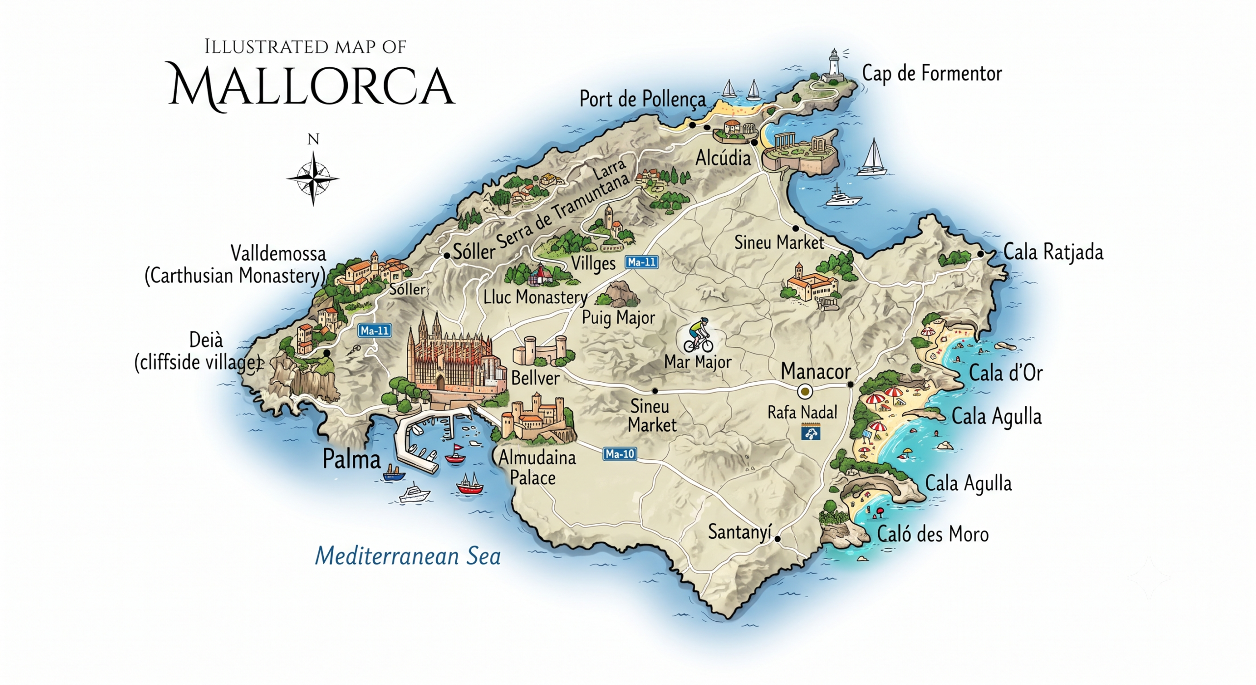
Getting information about the map of Majorca before a stay or exploration of the island promises a much richer experience. Whether to plan bucolic walks between mountains and idyllic beaches, to discover the picturesque towns and villages, or to target the places to visit in every corner of this Balearic island, having a good map of Majorca proves useful. This article offers a comprehensive overview on how to effectively use a Majorcan geographic map, discusses the interest of a tourist map, details the main regions and municipalities, and provides tips to make the most of this true visual guide.
Why use a map of Majorca to prepare your trip?
Discovering Majorca without a cartographic support would mean missing many hidden secrets on this half-Mediterranean, half-mountainous island. Thanks to a precise geographic map, it becomes much easier to trace a coherent itinerary linking beaches, wild nature, and cultural discoveries. This tool suits both explorers who come to enjoy the calm of the hinterland and lovers of swimming in turquoise waters.
A map of Majorca not only reveals the general organization of the island but also allows spotting the different regions and municipalities in just a few moments. For those who like to customize their route according to their interests, having a good map offers unmatched comfort in preparation but also during the journey, especially when venturing off the beaten path towards less frequented places to visit.
Understanding Majorca’s territorial structure through the map
The island of Majorca presents a surprising diversity for its size. Several regions stand out by their character, each possessing its own natural and heritage attractions. A global overview with a tourist map helps to understand this unique mosaic where each area deserves to be explored.
This territorial analysis can serve both curious vacationers organizing active holidays and those seeking relaxation in small quiet villages. On the ground, knowing how to interpret a precise map strengthens the feeling of moving intelligently, while optimizing travel times between sea, mountain, and lively towns.
Mapping the island’s main regions
Majorca is mainly divided into several distinct zones: the northwest dominated by the Serra de Tramuntana, the hilly east, the south with vast agricultural plains, and the bay of Palma. Each of these parts offers impressive landscapes, between steep rocky peaks, discreet coves, and flat expanses covered with olive trees.
The tourist map often highlights these natural divisions and allows adapting the program to the desire for change of scenery, whether one wishes to spend long hours on the beach or hike the trails in the heart of nature.
Details of municipalities and authentic villages
The administrative division counts no less than 53 municipalities. A good geographic map locates these entities; some are famous, others remain treasures preserved from mass tourism. Among the unmissable towns and villages are Sóller, known for its old railway and bohemian atmosphere, Deià which attracts artists, or Valldemossa known for its charterhouse and flowered alleys.
When preparing a visit, it is wise to consult a detailed map of Majorca of the central villages like Pollença, Artà, or Sineu, true guardians of Majorcan traditions. Getting lost in their small streets already constitutes an adventure.
The advantages of a tourist map of Mallorca for smart travel
Unlike a purely physical map, the tourist map contains a set of information tailored to calmly organize all stages of the stay. It clearly marks the must-see places such as the paradisiacal beaches of the east coast or the viewpoints offering spectacular panoramas of the sea.
Another major advantage lies in the ability to quickly spot the main roads, the winding secondary roads ideal for cycling, or walking routes. With a customizable map online or on paper, it is hard to miss a local curiosity or a privileged viewpoint.
Easily identify the island’s key sites
Thanks to a well-designed tourist map, it becomes easy to visualize where the most beautiful beaches, important historical sites, and protected natural areas are concentrated. For example, Cala Varques, Es Trenc, or Formentor are listed, as well as the Alfabia gardens or the Mondragó natural park.
For those who like to combine culture and discovery, the precise location of monuments such as the Palma de Mallorca Cathedral, medieval castles, or unique museums facilitates daily planning. Since distances between each site can sometimes be misleading, a smooth spatial visualization greatly simplifies the choice of visits to group together.
Navigate nature trails and dream landscapes
Mallorca’s natural richness is part of its identity. Walking on the trails of the Serra de Tramuntana, a UNESCO World Heritage site, or strolling around the lagoons of the S’Albufera natural park becomes reassuring with a reliable map in hand. Different symbols precisely indicate the starting points of hikes, as well as difficulty levels.
Besides the trails, the map helps to pre-select secluded beaches, secret coves far from the summer crowds, or even panoramic routes perfect for a road trip or a bike getaway. It is particularly appreciated for following thematic routes focused on the nature and varied landscapes of the island.
What are the advantages of an interactive or digital map for exploring Mallorca?
In recent years, digital tools have revolutionized the way we discover the Balearic Islands, especially their largest island. The interactive map has now become essential. Accessible from a smartphone or tablet, it allows real-time updates on traffic conditions, site openings, or weather.
This digital format provides access to practical filters: recommended beaches for families, typical villages not to be missed, natural sites suitable for hiking… The dynamic experience of a digital map significantly improves the comfort of the modern traveler, especially to adapt their itinerary in the face of unforeseen events.
- Automatic GPS position display to instantly locate searched places.
- Ability to save favorites or add personal notes during exploration.
- Frequent updates on local events, temporary closures, or new marked trails.
- Advanced search by category (beaches, villages, monuments, nature, and landscapes).
- Multi-platform compatibility to navigate everywhere, even without constant connection.
Its evolving nature greatly appeals to younger generations, fans of technology and flexibility in trip organization. This does not prevent appreciating, during certain travels or when the network is scarce, the reliability of a more traditional paper geographic map.
Focus on Palma de Mallorca and the other iconic towns to discover
It is impossible to mention a map of Mallorca without mentioning the capital, Palma de Mallorca. Located in the southwest, this city concentrates a major part of the island’s artistic and architectural riches. On maps and tourist maps, it appears as an ideal gateway, combining ancient history, urban beaches, and a refined Mediterranean atmosphere.
Once the visit to the city is completed, it is worth taking a closer look at the map with the secondary towns scattered across the territory. Each reveals a different facet of the Majorcan soul.
Palma de Mallorca: cultural and economic crossroads
As a nerve center, Palma holds treasures such as the Gothic cathedral overlooking the bay, the hidden patios of the old quarter, and the colorful markets where friendliness prevails. The urban plan details the different neighborhoods, from the port to the Ramblas, facilitating pedestrian strolls as well as gastronomic excursions.
Beyond the must-sees, Palma stands out for the energy of its festivals, its contemporary art museums, and its independent shops. On the tourist map, one appreciates spotting the urban beaches ideal for swimming breaks in complete freedom after diving into the city’s hustle and bustle.
Diversity and charm of the surrounding towns and villages
Not far from Palma, several municipalities radiate authenticity. Santa Maria del Camí, Esporles, and Calvià appear on detailed maps as oases of history, open to the surrounding countryside and crossed by cycle paths.
Further north, Alcúdia attracts with its Roman walls and traditional market, while Artà enchants craft lovers. From one town to another, simply consulting one’s map allows alternating between pristine beaches, castles, or breathtaking views of the sea and the peaceful hinterland.
Explore beaches, nature, and landscapes between classic maps and personalized plans
No matter the season chosen for the adventure, the resources offered by a map of Mallorca transform any stay into a fabulous sensory journey. Between the softness of the beaches caressed by clear waters, shaded trails winding along cliffs, or botanical walks in the heart of the mountains, the diversity of landscapes evoked invites lingering.
Favoring the discovery of secret spots remains the primary advantage of a good plan: from small coves sheltered from view to little-known nature reserves, every corner benefits from being precisely located. Certainly, improvising is part of the pleasure, but regularly consulting a map subtly guides towards new and memorable experiences.
How to choose the best map to organize a successful visit to Mallorca?
Faced with the multitude of options – detailed geographic map, elaborate tourist map, or interactive plan –, the choice will depend on the style of vacation planned. Adventurers often favor topographic precision, useful on steep trails. Families and groups of friends, on the other hand, opt for a colorful version, enhanced with simple pictograms to easily locate beaches, museums, or markets.
Consulting different versions allows cross-referencing information and efficiently juggling between quick routes and contemplative breaks. Some formats, very suitable for cycling or walking, emphasize elevation changes or infrastructures accessible to all ages. Thus, designing a route according to one’s tastes has never been so intuitive.
FAQ-Majorca map
Majorca is the largest island of the Balearic Islands in the Mediterranean Sea. It belongs to Spain and is located east of the Iberian Peninsula.
Palma is the capital of Majorca and its main economic and tourist center. The island has a population of approximately 940,000 people.
A map of Majorca helps locate its beaches, villages, mountains, and main attractions. It is also useful for planning a trip and organizing travel around the island.
