
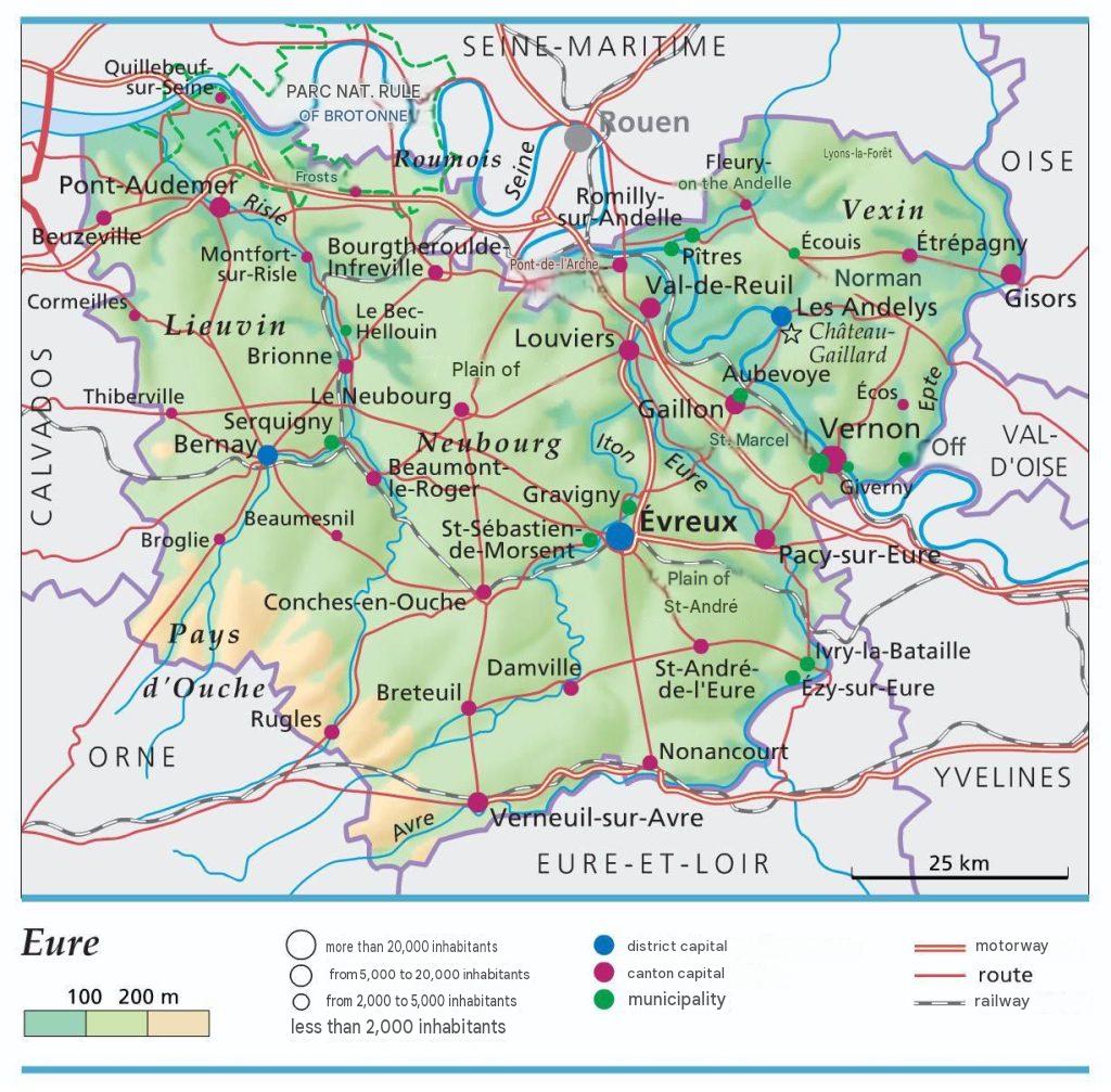
What you need to know about the Eure department ?
Here is an overview of department 27, a French department located in the northern part of the country. The department is called Eure, a name derived from the river that flows through its center and is one of its defining landmarks. The prefecture and administrative capital of Eure is Évreux, and it also has two subprefectures: Les Andelys and Bernay. The Eure department covers a total area of 6,040 km² and has a population of approximately 606,634 inhabitants. As a result, its population density is 100 inhabitants per square kilometre, making it the 42nd most populous department in France.

Which Departments Border Eure?
The region where the Eure department is located is Normandy, so its neighboring departments are: Seine-Maritime, Yvelines, Val-d’Oise, Oise, Eure-et-Loir, and finally Calvados. This department also borders the Atlantic Ocean; on its coastline is the Seine Estuary.
What is the climate like in the Eure department?
Indeed, Eure has a rather oceanic climate, characterized by a strong influence of oceanic winds coming from the Atlantic. Moreover, this climate is marked by significant fluctuations in temperature and humidity almost all year round.
Several factors can locally influence the climate: the first being its proximity to the coast and its altitude. That is to say, temperature fluctuations reach -0.6 °C for every 100 meters of altitude gain. After that, there is the presence of vegetation cover and the geological nature of the soils. These also greatly influence temperatures and the environment, especially in the East and southern areas.
Thus, the towns of Lieuvin, Auge, and the Pays d’Ouche exhibit a rather oceanic climate, somewhat humid in summer and cool in winter. On the other hand, other areas with lower altitudes (notably Saint-André and the Madrie plateau) have a less rainy climate, with annual precipitation below 600 mm.
This characterizes the department as the driest in its parent region. For its prefecture, the temperature difference between night and day means that during the day, temperatures are warmer and at night, cooler. This causes a lot of mist and fog. It is a typical feature of a temperate oceanic climate, with precipitation ranging between 600 and 700 mm annually.
What are the most important towns in the Eure department?
Here are the towns and/or villages you should visit once you are in the 27; these are the most beautiful villages of Eure.
- Lyons-la-Forêt
- Le Bec-Helloin
- Giverny
- Vieux-port
- Saint-Sulpice-de-Grimbouville
- la Haye de Routot
- Acquigny
- Cormeilles
- Saint Georges du Vievres
- la Ferrière sur Risles
What are the most important communes in the Eure department?
In terms of area, we have listed below the most important towns in the Eure department:
- Les Andelys
- Les Baux-de-Breteuil
- Breteuil
- Beaumont-le-Roger
- Vernon
- Le Fidelaire
- Verneuil d’Avre et d’Iton
- Louviers
- Évreux
- Val-de-Reuil
Here are the most important municipalities in the Drôme department ranked by largest area:
- Évreux
- Louviers
- Gisors
- Pont-Audemer
- Gaillon
- Vernon
- Val-de-Reuil
- Bernay
- Les Andelys
- Verneuil d’Avre et d’Iton

FAQ – Eure map
A map of Eure helps you locate the department’s main towns, roads, and natural sites. It also provides an overall view of its geographical organization.
A map helps you plan your itinerary by identifying municipalities, transportation routes, and places of interest. It also makes it easier to organize your travel and sightseeing.
Yes, it helps you discover villages, natural areas, and major tourist attractions. It is also a practical resource for educational activities and geographic research.
