
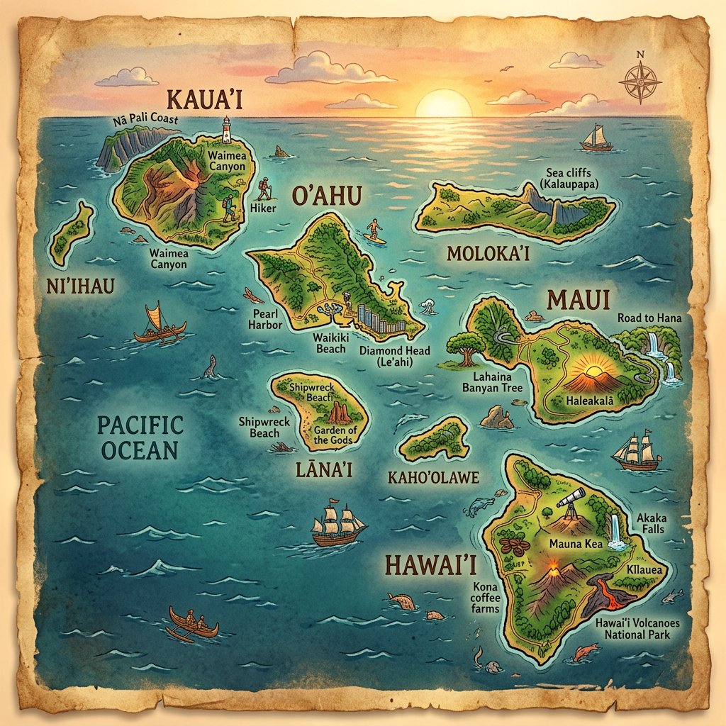
Preparing a trip to Hawaii means offering yourself a total change of scenery in the heart of a unique archipelago, known for its volcanic landscapes, spectacular beaches, and the diversity of its main islands. Choosing the right map quickly becomes essential to avoid missing the most beautiful sites, organizing your travels, or better locating the must-see places of the territory. Whether it is a tourist map to spot hidden treasures, a detailed city plan, or a road map to optimize your road trip, each medium provides a valuable perspective during a trip to Hawaii.
The use of geographical maps goes far beyond simple orientation. They also serve to imagine your itinerary by visualizing distances, identifying typical reliefs, and discovering the abundance of landscapes across different islands of the archipelago. These tools are often enhanced with images or photographs, allowing you to project yourself and adjust your desires according to what each place suggests.
What is the purpose of a Hawaii map during a trip?
Setting out to discover the main islands of Hawaii sometimes involves juggling several cartographic supports, as each map meets a specific need depending on the stage of the stay. Some facilitate the organization of an itinerary, others enrich the experience by locating little-known natural sites, or even lively villages far from the usual tourist trails.
Experienced travelers know that consulting a tourist map makes it easier to select major points of interest while revealing some secret spots accessible only after a few route adjustments. Using a geographical map also offers a better understanding of the territory’s morphology, the real distances between beaches, volcanoes, and lush forests, as well as the exact location of major cities like Honolulu or Hilo.
- Plan must-see visits and excursions into nature.
- Visualize the reliefs and anticipate travel conditions.
- Easily identify access to beaches and protected sites.
- Avoid areas that are difficult to navigate or poorly marked.
- Optimize the time spent on site without going in circles.
Discover the different maps available to explore the archipelago
The Hawaiian archipelago offers a range of supports suited to all types of travelers. Whether you prefer hiking, water activities, or cultural getaways, it is possible to use simple plans or much more detailed maps, enriched with images, symbols, or clear colors to better distinguish the sub-regions of the main islands.
Even before arriving on site, relying on an interactive map or a printed version allows you to note potential routes, anticipate the stages of the circuit, and compare itineraries proposed by specialized guides. This preparation helps limit frustration in the face of unforeseen events, especially in case of weather changes or temporary closures of certain accesses.
Why use a tourist map of Hawaii?
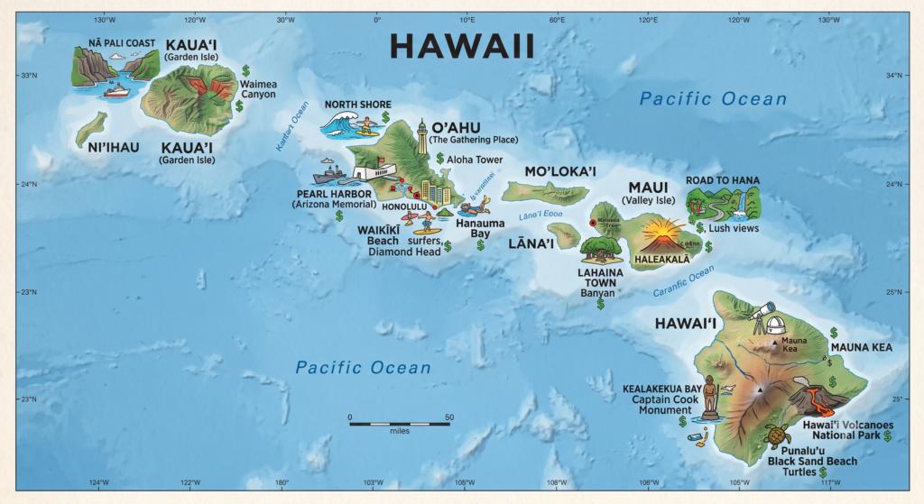
The tourist map is probably the favorite tool of vacationers looking for a complete overview. Easy to read, it gathers on a single support the main attractions of each island: well-known beaches, national parks, active volcanoes, nature reserves, and historic neighborhoods.
Some plans also include iconic images that help visually recognize key points of the landscape. This inspires organizing your trip around thematic circuits, whether focused on hiking, underwater exploration, or discovering Hawaiian traditions.
How does the road map help to travel between the main islands?
Navigating the roads of Hawaii is not complicated, but it is better to consult an updated road map to avoid missing essential junctions or ending up on a path unsuitable for a regular vehicle. Each road has its own specificities depending on the island traveled: long coastal routes, mountain switchbacks, or forest crossings deserve to be anticipated.
Having access to a reliable map of the local road networks greatly simplifies managing the timing between two visits. It also allows for booking accommodations strategically placed to avoid multiplying unnecessary driving hours.
Understanding the geographical structure of the archipelago through maps
The charm of Hawaii lies in its atypical composition. The archipelago includes several main islands, each with distinct landscapes and unique atmospheres. A well-designed geographical map provides a quick overview of the overall structure of the archipelago, the layout of the lands, and the actual extent of the oceans separating each island unit.
This detailed view is particularly useful for those wishing to visit several islands during the same trip. By correctly visualizing the space, it becomes easier to judge the feasibility of the itinerary, the unavoidable travel times by plane or boat, as well as the proximity of urban centers to the surrounding natural wonders.
Where are the main cities of Hawaii located?
The majority of visitors settle in Honolulu, located on Oahu, while keeping in mind that each main island has its own nerve center. Locating the cities on a map helps target necessary shopping, benefit from local services, or organize nightlife outings without wasting time.
Thus, Hilo, Kailua-Kona, or Lahaina are among the names to remember during an extended stay, especially since some peripheral neighborhoods abound with traditional markets, art galleries, or establishments dedicated to local gastronomy. A well-designed map greatly facilitates intra-urban exploration while clearly indicating the connection with the surrounding major roadways.
What types of geographical maps should be preferred for hiking in Hawaii?
Trekking or nature observation enthusiasts particularly appreciate specialized supports oriented towards hiking: contour lines, pictograms indicating waterfalls, marked trails, and forest reserves are systematically indicated. Photographing the map before departure can be wise if the network connection proves unreliable in some rugged areas.
This type of representation also highlights the environmental richness of the archipelago and encourages limiting impact on endemic wildlife by staying on authorized paths. Carrying a foldable paper map or downloading an offline version optimizes safety during extended walks off the beaten paths.
Visual contributions: how do images enrich the location spotting?
One of the major assets of modern supports lies in the presence of numerous images and photographs directly inserted on the map. Whether it is icons illustrating a legendary beach or aerial photos listing the emblematic volcanoes, these visuals strengthen spatial orientation during the first days on site.
Targeted illustrations encourage stepping off the standard route to reach a protected lagoon, a forgotten temple, or a remote beach. Visualizing the relief, the color of the sand, or the dominant vegetation also helps choose the stages that best match one’s current desire, adding a sensory dimension to the simple reading of a map.
Can interactive maps of the archipelago be found?
Many organizations today offer mobile applications or web platforms allowing the display of complete interactive maps of Hawaii. These include different layers (cities, roads, natural areas) that each user can activate or hide at will, to fully customize their virtual exploration before departure or during the stay.
This gain in flexibility makes preparation more enjoyable and allows all useful information (photos, itinerary tips, weather alerts) to be centralized on a single screen. Traveling light then becomes a reality, even when a passion for detail guides daily choices.
What does a detailed map of Hawaiian cities bring to everyday life?
Having a precise map of downtown areas opens up the possibility to stroll through the streets, discover markets, locate transport stops, or quickly access a first aid station if needed. The zoom levels of digital maps or their printed versions allow adaptation to all types of visits and paces of stay.
Thanks to these reliable supports, it becomes easier to meet locals, follow a thematic route (street art, tropical gardens, historic architecture), and leave enriched with authentic memories. The complementarity between tourist maps and urban plans encourages spontaneity while providing a reassuring framework for any improvisation.
Practical advice for choosing and using your Hawaiian map well
The success of a trip to the archipelago partly depends on the accessibility and quality of the materials used. Whether paper or digital, it is important to select the map that corresponds to your primary uses and equipment. Some still prefer to leaf through a printed guide, while others rely on GPS apps to benefit from automatic route recalculation.
Make sure to check that downloaded versions are up to date, especially regarding restrictions (protected areas, intermittent traffic…). On the ground, alternating between several supports depending on the day’s needs increases your chances of fully enjoying the varied landscapes without risking disappointment during an excursion.
- Define your priorities (nature, city, beaches, culture) before choosing your map.
- Combine road maps and detailed plans to optimize inter- and intra-island travel.
- Opt for maps enhanced with images, particularly useful for visualizing must-see spots.
- Prefer offline files when the mobile network is expected to be limited.
- Seek advice from local tourist offices to obtain the latest editions of plans and official maps.
Visiting the Hawaiian archipelago means accepting to be surprised by the diversity of its territories. With the right map in hand, each stage reveals an unexpected face, every detour turns into a memorable experience, and the images engraved on visual supports quickly become memories shared long after returning home.
FAQ-Hawaii map
Hawaii is an American archipelago located in the center of the Pacific Ocean, between North America and Asia. This state consists of several volcanic islands known for their tropical landscapes and biodiversity.
The capital of Hawaii is Honolulu, located on the island of Oahu. This city is the main economic, administrative, and tourist center of the archipelago.
A map of Hawaii helps better understand the location of the main islands, volcanoes, and various tourist attractions. It is useful for planning a trip, discovering the geography of the archipelago, and organizing itineraries.
