
What you need to know about the Loire department ?
First, the Auvergne-Rhône-Alpes region is made up of several departments, including the Loire. It is actually the 42nd French department. The name “Loire” actually comes from a river that runs through the center of the territory of this department for about 100 km.
Géographiquement, le territoire du département 42 est très vaste, s’étendant à 136 km de long du sud au nord. Le point le plus au nord-est est la commune d’Urbise et le point le plus au sud-est Bourg-Argental. En revanche, la largeur dudit département est de 50 km. Vu la superficie de 4 781 km² du territoire de la Loire et la population qui se chiffre à 776 508 habitants, la densité de population est de 162 habitants au km².
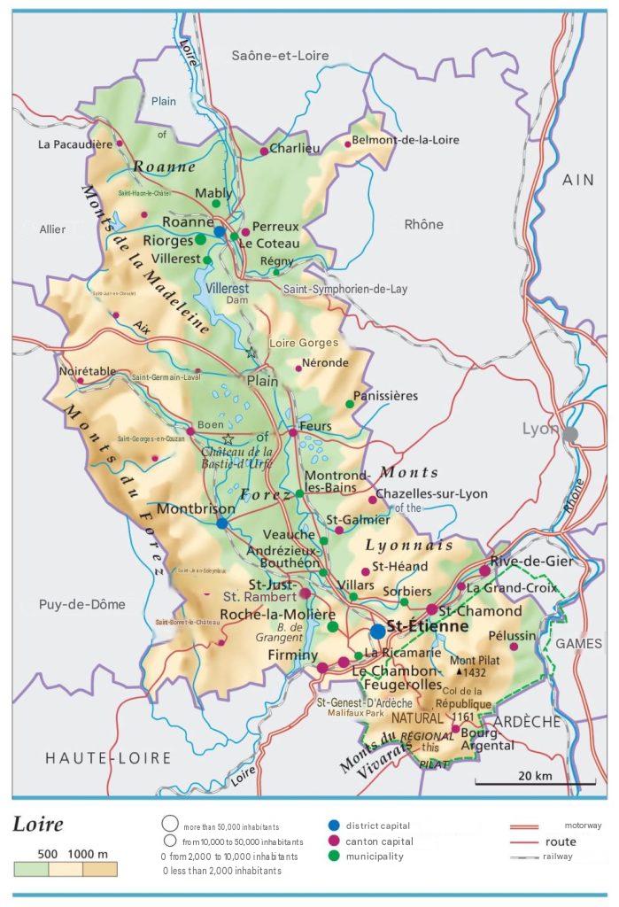
The prefecture, administrative center, and also the most important city of the department is called Saint-Étienne, and there are 2 sub-prefectures: Montbrison and Roanne. Administratively, the territory of the Loire is divided into 3 arrondissements, legislative constituencies, 21 cantons, 10 intercommunalities, and 323 communes.

Which departments border the Loire department?
Indeed, the Loire department borders 7 departments, namely: the Rhône department, the Isère department, the Haute-Loire department, the Ardèche department, the Saône-et-Loire department, the Puy-de-Dôme department, and the Allier department.
What is the climate like in the Loire department?
The Loire department could be likened to a continental or near-continental climate. This type of climate is characterized by temperatures that vary according to altitude. Moreover, there are climates that differ on mountain slopes, plains, and valleys.
With its coast facing west, the climate of this department is both temperate and oceanic. In the west-south section, for example, winter is milder (average temperature of 5°C). During summer periods in this region, temperatures hover around 18°C. On the other hand, precipitation amounts to about 820 mm per year.
In the west-south part, it is the warmest zone of department 42. Winter temperatures do not drop below 3°C, and sometimes the area near the sea can reach high temperatures.
As you approach the coast facing the Atlantic, the climate type is oceanic. This climate is strongly influenced by the presence of an estuary on the Loire and the absence of significant relief. Thus, in this zone, winter temperatures are mild (between 1 and 9°C). This period is also very rainy. During summer periods, the weather is nice and temperatures are ideal, ranging between 17 and 35°C. However, during these summer periods, there may be spells of intense heat, even heatwaves.
Annually, therefore, precipitation can be intense and even reach 820 mm per year, but this can vary from year to year. We have even seen heavy snowfall.
This shows that the climate of the Loire department is very favorable to agriculture. Vegetation is well developed across the territory. But in the western part of the department, there are sometimes cyclonic depressions coming from the Atlantic coasts.
What are the best cities in the Loire department?
For this ranking, we have chosen the 10 largest communes in the Loire department:
- Saint-Étienne
- Roanne
- Saint-Chamond
- Firminy
- Montbrison
- Saint-Just-Saint-Rambert
- Rive-de-Gier
- Le Chambon-Feugerolles
- Riorges
- Roche-la-Molière
What are the largest municipalities in the Loire department?
For this ranking, we have chosen the 10 largest municipalities in the Loire department:
- Saint-Étienne
- Saint-Bonnet-le-Courreau
- Saint-Genest-Malifaux
- Saint-Just-Saint-Rambert
- Chalmazel-Jeansagnière
- Saint-Chamond
- Usson-en-Forez
- Perreux
- Noirétable
- Saint-Priest-la-Prugne
For this ranking, we have chosen the municipalities with the highest population densities. So, here are the 10 most populated municipalities in the Loire department:
- Saint-Étienne
- Saint-Chamond
- Montbrison
- Saint-Just-Saint-Rambert
- Riorges
- Roanne
- Firminy
- Rive-de-Gier
- Le Chambon-Feugerolles
- Roche-la-Molière

FAQ – Loire map
A map of Loire displays the main municipalities, roads, waterways, and the department’s administrative boundaries. It also helps users better understand the geography and territorial organization of this department located in the Auvergne-Rhône-Alpes region.
The prefecture and main city of Loire is Saint-Étienne, a city recognized for its industrial heritage, economic dynamism, and vibrant cultural life. The department also includes important towns such as Roanne and Montbrison.
A map of Loire is useful for planning a trip, locating a municipality, or discovering the department’s landscapes, natural sites, and heritage. It also makes traveling easier and provides a clear overview of the entire territory.
