
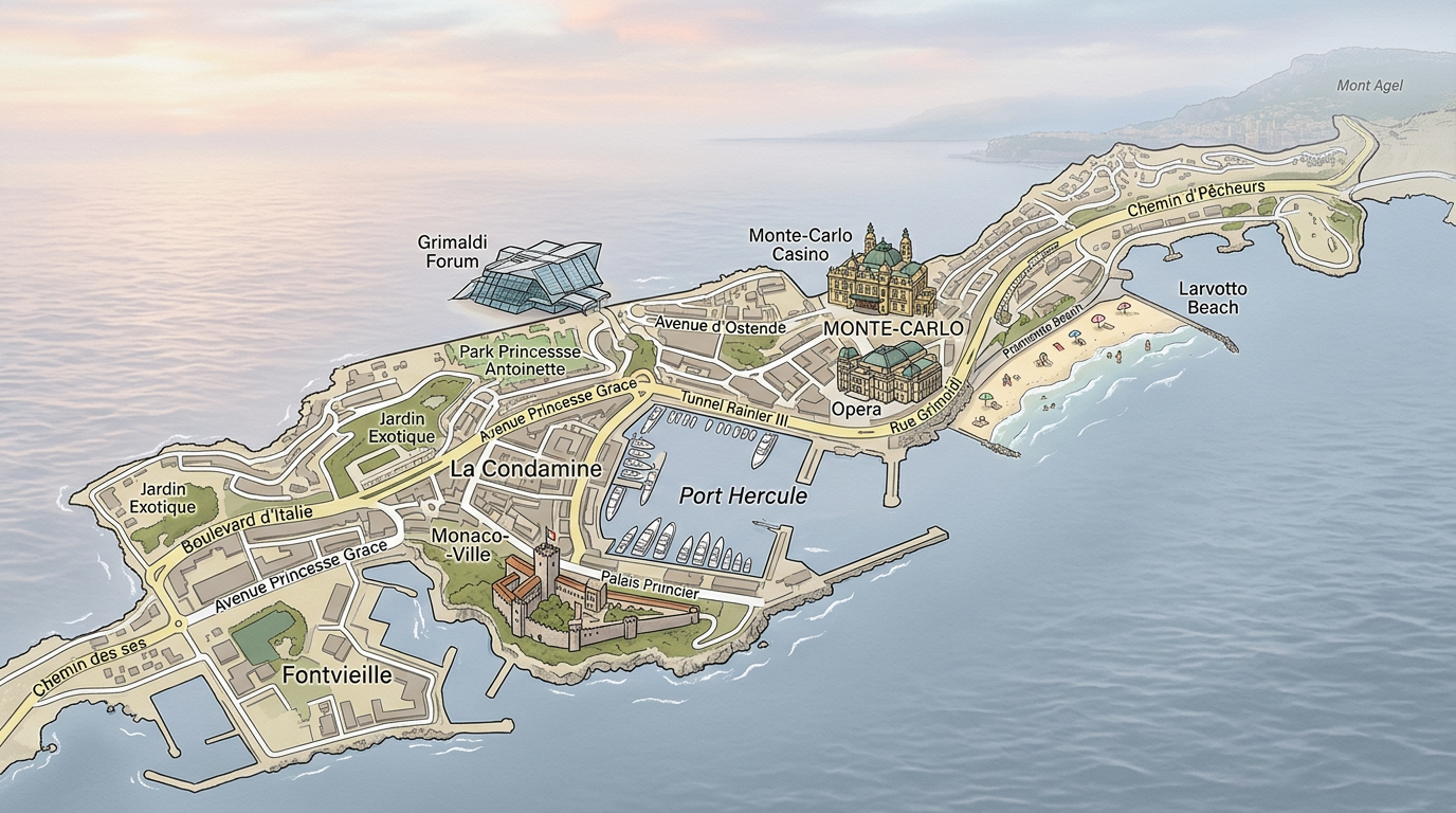
Nestled between sea and mountain on the French Riviera, Monaco fascinates with its luxury, unique urban density, and cosmopolitan atmosphere. When you want to discover this tiny but intense territory, relying on a Monaco map quickly proves essential. Whether to locate the districts of Monaco, organize a quick visit, or prepare for a longer stay, the right Monaco plan helps visualize everything clearly.
From the legendary rock to the Larvotto beaches, the principality offers many tourist sites and a multitude of activities in Monaco. The places to visit abound in this Mediterranean enclave where every square meter counts. To find your way, there are now several practical solutions, from the traditional paper map to the interactive map on mobile. Let’s discover together how to make the most of a Monaco plan to make your visit unforgettable, whether it is professional, family-oriented, or simply curious.
The geography of Monaco seen through a map
Despite its area of only two square kilometers, the principality reveals an astonishing diversity of urban and natural landscapes. A Monaco map allows you to understand exactly where the various key points of interest, iconic monuments, but also the less well-known private areas are located.
Situated on a hillside and facing the Mediterranean, Monaco spreads its districts over distinct levels that only a readable Monaco plan can untangle. This unique topography explains why walking around can hold some surprises, especially during a first visit.
Essential landmarks of the principality
On a detailed map, you can easily identify certain strategic points such as Port Hercule, the princely palace perched on the rock, or the gardens overlooking the sea. This facilitates quick orientation when it comes to reaching one of the restaurants or hotels scattered throughout the city.
To fully enjoy the principality, it is useful to know how to locate some practical services such as public parking lots, bus lines, or the main pedestrian connections winding between the old town and the waterfront. This information is easily read on an interactive map accessible from a smartphone.
Borders, access, and natural environment
Monaco is landlocked between France and the Mediterranean, with no direct border with Italy. On a Monaco plan, road access via Cap-d’Ail, Beausoleil, or Roquebrune-Cap-Martin is clearly indicated, as well as the steep slopes bordering the city to the east and west.
Some areas offer spectacular views of the sea, punctuated by beaches or historic esplanades. The very green dimension of certain districts charms as much as the density of modern buildings, giving the principality a unique balance between urbanization and controlled nature.
The districts of Monaco: how to distinguish them on a map?
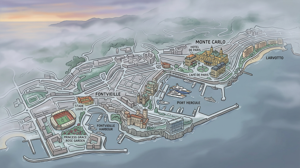
Within its small borders, Monaco is divided into various districts of Monaco, each with its own identity. A well-designed map highlights these different zones, making discovery easier according to desires and interests. From Monte-Carlo to Fontvieille, each district deserves attention, as it offers varied and complementary experiences.
Using an updated Monaco plan helps avoid common confusions between residential areas, shopping districts, or historical sections. For travelers who want to optimize their time, it is also a definite asset in planning their itinerary through streets and alleys.
The rock: history and traditions
The historical heart of the principality, the rock attracts with its narrow streets, old facades, and prestigious museums. On a Monaco map, this district corresponds to a small peninsula overlooking the old port. The Monaco plan easily indicates the place of the Prince’s Palace, that of the cathedral, or the location of the Oceanographic Museum, all gathered within this compact area conducive to walking.
These streets also house gourmet addresses and typical shops appreciated throughout the year. Navigating them with a precise plan allows you to grasp all the subtleties without missing hidden corners or discreet staircases, true local shortcuts.
Monte-Carlo: elegance, shopping, and leisure
A symbol of Monegasque glamour, Monte-Carlo concentrates famous casinos, prestigious hotels, and panoramic terraces around the square of the same name. In this area, an interactive map proves useful as traffic can be heavy, especially during major social events held throughout the year.
Besides the famous Casino, this area also hosts numerous restaurants and high-end brands, offering an unparalleled shopping experience. Many activities in Monaco revolve around this flagship district, visible on any Monaco map worthy of the name.
Fontvieille and Le Larvotto: modernity by the sea
Fontvieille represents the contemporary face of the principality, built on a modern embankment. On any current Monaco map, this extension is clearly identifiable at the southwestern end. Dotted with marinas, cultural spaces, and sports facilities, it also offers several options for dining or accommodation.
The Larvotto district stretches along the beach, ideal for walks and relaxation. A map shows the alignment of public beaches, beach clubs, and establishments frequented during the summer season, forming an idyllic break in the heart of the urban area.
Where to find a Monaco map suited to your needs?
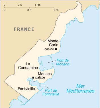
Depending on how the stay unfolds, different cartographic supports are more suitable. Between interactive maps, maps offered at the tourist office, or dedicated apps, everyone finds a reliable option to navigate the city effectively.
With recent technological advances, equipping oneself with a GPS integrated into an interactive map greatly facilitates navigation, especially in areas where changes in altitude and multiple passages make landmarks less obvious.
Traditional maps and paper plans
Many visitors remain attached to the paper format, convenient to consult without an internet connection. Upon arrival in Monaco, several stands offer Monaco maps that are very readable, mentioning streets, monuments, and main sites to visit, either free or for a small fee.
This format remains appreciated by groups or families wishing to organize quickly but sometimes suffers from a lack of updating. It advantageously complements, for some, the use of a smartphone during extended trips through several Monaco districts in the same day.
Mobile applications and interactive maps
For those who prefer digital simplicity, several free apps include a Monaco map regularly updated. Besides instant location, they often allow filtering displays according to interests: booking hotels, selecting nearby restaurants, or quick access to activities in Monaco from one’s phone.
On a business trip or for lovers of personalized walks, the interactive map provides access to very useful features, such as calculating multimodal routes (bus, walking, electric cars) or dynamic display of schedules and availability in parking lots.
Discover the must-see tourist spots thanks to the Monaco map
Organizing a successful visit often begins with selecting the best sites to visit and activities in Monaco available to all types of travelers. Thanks to a detailed map, planning a day brings peace of mind and optimizes the time spent on site. Here are some suggestions chronologically accessible according to the layout of the Monaco districts on the Monaco map.
Exploring each district from a central point, such as the train station or Port Hercule, varies according to your priorities: culture, gastronomy, nature walks, or nightlife entertainment, the city is full of interesting stops to plan in advance.
- Visit to the princely palace and walk through old Monaco
- Relaxation on the Larvotto beach
- Stroll in the Saint-Martin gardens or the Princess Antoinette park
- Dinner in one of Monte-Carlo’s renowned restaurants
- Stay in upscale hotels or unique accommodations
- Discover exhibitions at the Grimaldi Forum or a show at the opera
Integrating these steps on a customized map ensures a coherent and smooth experience, avoiding delays or unnecessary searches. Access to transportation also has clear indications on most interactive maps, facilitating the transition from one site to another.
It should not be forgotten that Monaco also offers unusual activities: karting sessions at the port, guided tours of the underground tunnels, or exploration of the coastal path linking the principality’s surroundings to the neighboring French coastline.
Practical tips for using a Monaco map effectively
Memorizing certain tips allows turning a simple day of sightseeing into a real adventure. Using a detailed map, whether digital or traditional, eases many uncertainties, especially during major events hosting crowds and specific activities.
Taking the time to analyze the principality’s vertical structure saves many unnecessary efforts, particularly during long transfers between the rock and the waterfront. Public elevators, numerous but sometimes little known, are thus prominently featured on every recent map.
Plan your routes according to time and season
Pedestrian routes vary in traffic depending on the time of day. Planning your trips in advance limits congestion, guaranteed by careful reading of the map. In summer, favor the coolness of the gardens, while in winter, opting for sheltered esplanades avoids drafts at the port.
This also applies to the choice of transport options: some buses run with increased frequency during major gatherings, while at other times, walking or renting an electric car proves faster. The different modes are illustrated on most available maps.
Adapt your searches to your desires
Whether traveling as a couple, family, or with friends, the order of visits or the location of restaurants and hotels changes significantly. Knowing how to filter the offer according to your expectations – atmosphere, culinary specialties, proximity to sites to visit – optimizes any city discovery.
The interactive map responds well to this flexibility: in a few clicks, comparing locations, menus, prices, and reviews makes decision-making easier, offering real time savings and increasing the overall comfort of the chosen tourist circuit.
A tailored experience to explore Monaco differently
Whether it is a first stay or a regular visit, the combined use of the Monaco map and connected resources greatly broadens horizons. Wandering between iconic sites and hidden corners becomes spontaneous once the landmarks are acquired.
Over the years, the way of exploring the city evolves, as does the digital offer now accessible to all. Having your own Monaco map, accompanied by precise recommendations on the neighborhoods to prioritize, opens the way to free and creative exploration. This is a lively and authentic way to savor the richness of an extraordinary principality, never losing your sense of adventure.
FAQ: Monaco map
The Government Tourist and Convention Authority offers comprehensive official maps available online or at their information desks. These documents list iconic sites, gardens, and main public access points.
Yes, the Principality’s interactive maps include the many elevators, escalators, and public passages that facilitate travel through the steep terrain. They are essential for getting around easily between the various districts.
During the Grand Prix period, specific maps are published to visualize the circuit layout, grandstands, and restricted access areas. You can view them on the official Automobile Club de Monaco websites.
