
Essential Information about Malawi
Malawi is an African country located in the southern part of the continent. Officially called the Republic of Malawi, this country is landlocked and bordered by Mozambique, Zambia, and Tanzania. The territory of Malawi covers an area of 188,844 km², inhabited by approximately 21,196,629 people (2024 estimate).
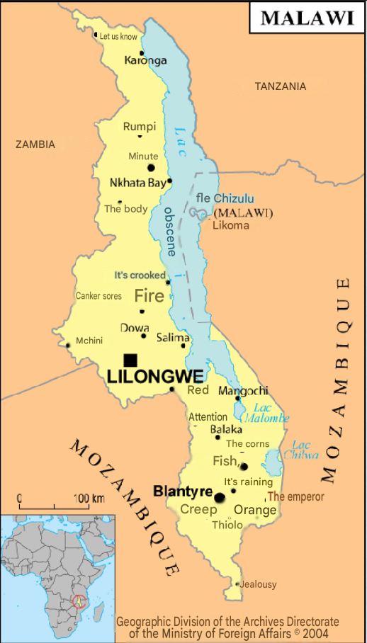
A country of the eastern Rift centered on a spectacular elongated lake, Malawi is explored by combining the lakeshores, parks (Liwonde, Nyika), and highlands (Mulanje). A detailed map helps balance stages, altitudes, and border crossings, while accounting for the rainy seasons and road links.
Malawi ranks among the most densely populated countries in Africa, holding the 64th position worldwide in population and the 99th in area. Its capital and largest city is Lilongwe. The official currency is the Malawian kwacha (MWK), and the official languages are English and Chewa. The international dialing code for Malawi is +265.
| Item | Details |
|---|---|
| Official Name | Republic of Malawi |
| Capital | Lilongwe |
| Population | ~20–21 million inhabitants, high density around the lake and plateaus |
| Area | ~118,484 km² |
| Relief & Hydrography | Rift Valley, Lake Malawi (Nyasa), Shire River, Shire plateaus, Mulanje Massif (3,002 m) |
| Climate | Tropical with rainy season (Nov.–Apr.) and dry season (May–Oct.); cooler in highlands |
| Languages | English (official), Chichewa (widely spoken), other local languages |
| Currency | Malawian kwacha (MWK) |
| Major Cities | Lilongwe, Blantyre, Mzuzu, Zomba |
| Economy | Agriculture (tobacco, tea, sugar), lake fishing, hydroelectricity, services, tourism |
| Points of Interest | Lake Malawi National Park (UNESCO), Cape Maclear, Likoma/Chizumulu Islands, Liwonde, Nyika Plateau, Mount Mulanje |
| Access | Airports: Lilongwe (LLW), Blantyre (BLZ); road border posts with Tanzania, Zambia, Mozambique |
| Advice | Plan for health (malaria), seasons and road conditions; book parks and accommodations on the lake shores during high season |
Population of Malawi
The Malawian population is estimated at approximately 21.2 million inhabitants (2024) with a natural growth rate of 3.31% per year.
The fertility rate is particularly high, reaching 5.4 children per woman, while the birth and death rates are respectively 40.7‰ and 7.7‰.
The life expectancy at birth is 62.2 years, and the average age of the population is only 16.6 years, indicating a very young and rapidly growing population.
The sex ratio is balanced, with 98 men for every 100 women.

Languages Spoken
Malawi is a multilingual country where Chichewa (Chewa), the national language, is the most spoken.
The main languages used in the country are:
- Chichewa (official)
- Chinyanja
- Chiyao
- Chitumbuka
- Chisena
- Chilomwe
- Chitonga
Ethnic groups
The population is made up of several Bantu ethnic groups spread across the territory:
- Chewas
- Nyanjas
- Tumbukas
- Wayaos
- Lomwes
- Senas
- Tongas
- Ngonis
Malawi is thus distinguished by a great linguistic and cultural diversity, reflecting its Bantu heritage and its openness to regional exchanges in southern Africa.
Climate of Malawi
The climate of Malawi is categorized as a moderate tropical climate. Its topography is dominated by altitudes which have prevented an equatorial climate from establishing.
The hot and humid season occurs between September and April. Temperatures during this season range between 27 and 29°C in areas including the lake and the Shire valley.
The city of Lilongwe also experiences a similar climate during this period. The rest of the country, however, shows daytime temperatures between 23 and 25°C and nighttime temperatures between 10 and 14°C.
Colors of Malawi
The Malawian flag is composed of 3 colors arranged in horizontal stripes: black, red, and green from top to bottom. At the center of the black stripe is a red sunset with 31 rays representing hope. The black color represents the indigenous people, the green color represents nature, and the red represents the blood of martyrs.

To start, consult Malawi (map), then position your regional extensions with Tanzania, Zambia, and Mozambique. Finally, place the whole in the continental context via the overview Africa.
Which cities to visit in Malawi?
Blantyre
Blantyre is a magnificent city and one of the most dynamic cultural centers in Malawi.
Ranked among the most pleasant cities in Southern Africa, it combines historical heritage, modernity, and local authenticity.
You can visit the St. Michael and All Angels Church, an iconic religious site built in 1888, entirely from handmade bricks.
The city also houses the National Museum of Malawi, the Mandala House — the oldest building in the country — as well as several traditional cafés and local breweries where conviviality and culture blend.
Lilongwe
The political and administrative capital of the country, Lilongwe is a peaceful city with natural charm.
Its craft market attracts both locals and visitors, offering sculptures, artworks, artifacts, and handmade souvenirs.
Among the must-see sites: the Kamuzu Mausoleum, a national monument dedicated to Malawi’s first president, located near the Parliament building.
Also don’t miss the Four Seasons Garden, a botanical oasis renowned for its floral diversity and soothing beauty, ideal for a family stroll.
Zomba
Former capital of the country, Zomba is nestled at the foot of the famous Zomba Plateau, a lush mountain offering spectacular panoramas, waterfalls, and hiking trails.
It is a popular destination for its cool climate, its colonial heritage, and its serene atmosphere, conducive to relaxation and discovery.
Mzuzu
Located in the north of the country, Mzuzu is the largest city in northern Malawi and an important university and commercial center.
It is a gateway to the Nyika Mountains and the Nyika National Park, one of the country’s most beautiful natural areas, known for its mountain landscapes and wildlife.
Mzuzu is also known for its colorful markets, its local cafés, and its welcoming atmosphere.
Mangochi
South of Lake Malawi, Mangochi is a seaside town renowned for its golden sandy beaches and lakefront hotels.
It is a must-visit destination for enthusiasts of swimming, diving, and sailing.
The town is also full of colonial remains and old British buildings, reflecting its rich historical past.
Its peaceful atmosphere makes it one of the best places to relax and enjoy the country’s natural beauty.
Economy of Malawi

The economy of Malawi is mainly based on agriculture, which remains the essential driver of national growth.
This sector employs more than 80% of the active population and represents about 28% of GDP.
The main agricultural products cultivated and exported are tobacco, maize, cotton, tea, and sugarcane, which make up nearly 80% of the country’s exports.
Despite a solid agricultural base, the country remains economically fragile, heavily dependent on climatic conditions and international aid.
The industry and service sector are still underdeveloped, representing approximately 16% of GDP, mainly in agro-food processing and public services.

Key economic data (2024-2025 Estimates)
- Official currency: Malawian Kwacha (MWK)
- Nominal GDP: 5.43 billion USD
- GDP at purchasing power parity (PPP): 21.13 billion USD
- Annual GDP growth: 2.5%
- GDP per capita (PPP): 1,110 USD
- Poverty rate: 75% of the population lives below the poverty line
- Human Development Index (HDI): 0.416
Malawi faces major economic challenges: limited infrastructure, heavy reliance on subsistence agriculture, demographic pressure, and persistent inflation.
However, recent reforms aim to boost economic diversification, encourage foreign investment, and develop the energy, tourism, and telecommunications sectors, in order to build more sustainable growth.
FAQ: Malawi map
A Malawi map with roads, relief, and access to reserves allows you to link Lake Malawi (Cape Maclear, Likoma), Liwonde, and the Nyika Plateau without unnecessary detours.
Yes, a Malawi map with contour lines and main routes shows altitude variations and realistic speeds depending on the sections.
Prefer a Malawi topographic map (1:50,000/1:25,000) indicating trails, shelters, and water points to prepare distances and elevation changes.
It is better to have an offline/GPX Malawi map, as signage is uneven off main routes and in rural areas.
Yes, a regional Malawi map clearly locates entry points towards Tanzania, Zambia, and Mozambique to plan cross-border loops.
