
What you need to know about Morocco ?
Morocco is a country located in the northwest part of Africa. It is also called the Kingdom of Morocco due to its status as a regionalized unitary parliamentary constitutional monarchy. The largest city in Morocco is Casablanca but its capital is Rabat.
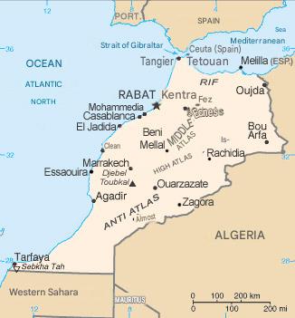
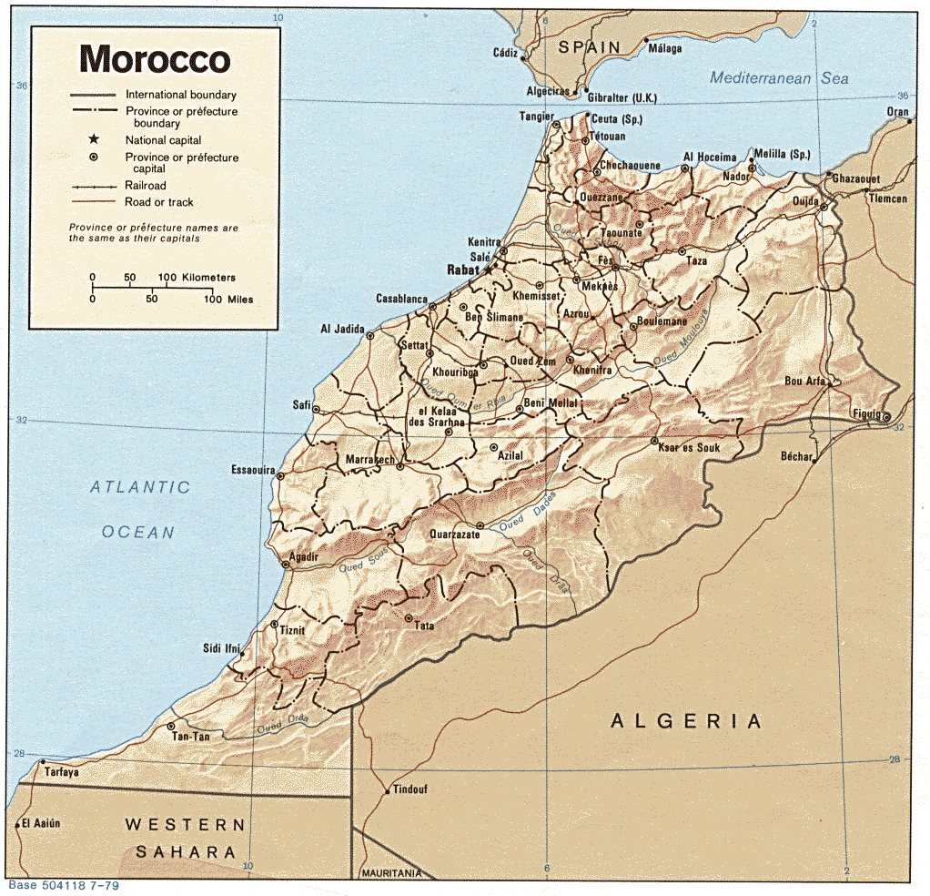
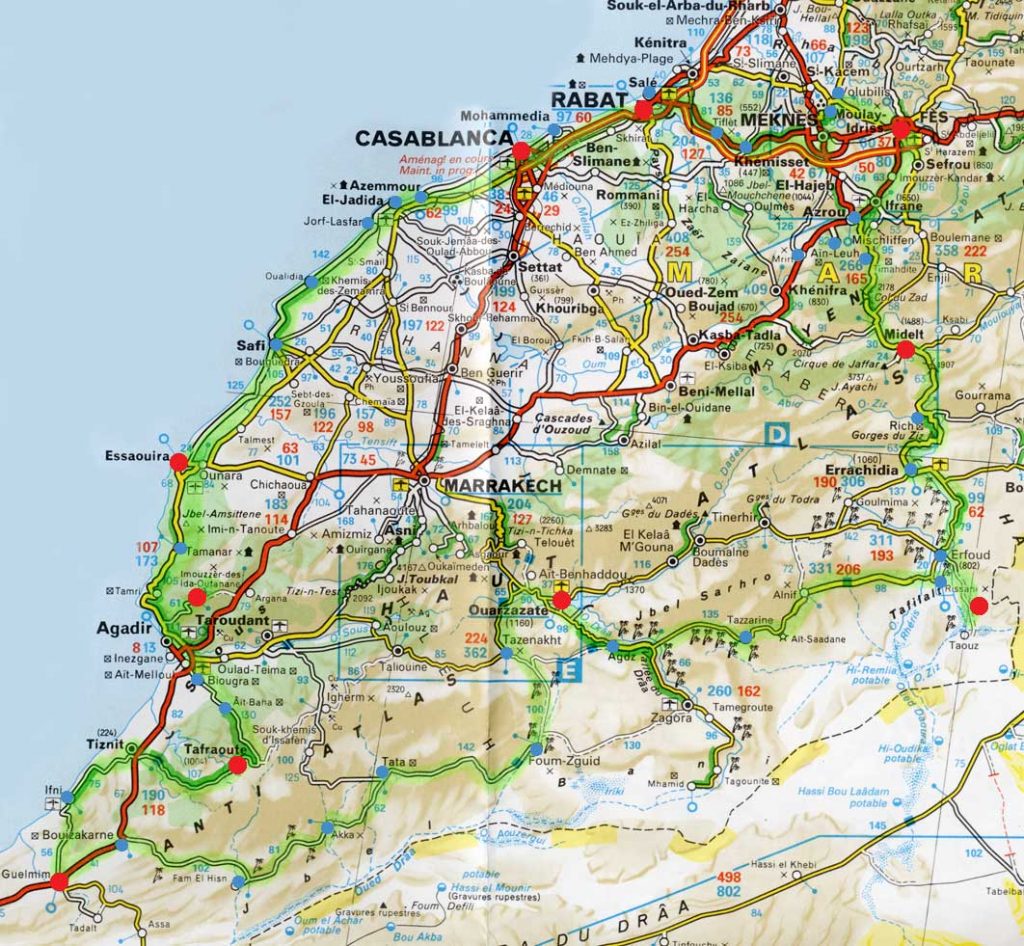
Between the Rif, the Atlas, and the gateways to the Sahara, the map of Morocco helps connect imperial cities, the Atlantic coast, and Saharan valleys. Aim for spring and autumn for mild temperatures, anticipate the temperature swings in the mountains and desert, and plan your trips along the main routes before branching out to the valleys.
The total area of Morocco is 446,550 km² (excluding Western Sahara) and approximately 710,850 km² including the territory of Western Sahara.
The Moroccan population is estimated at 37.4 million inhabitants in 2024.
The country ranks 40th worldwide by population and 58th by area.
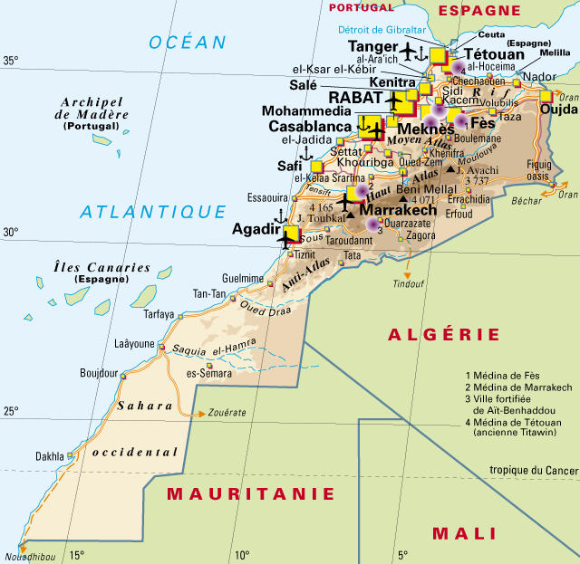
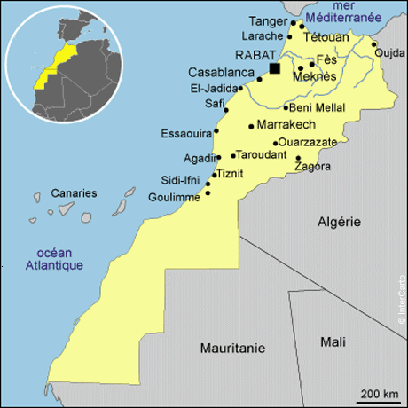
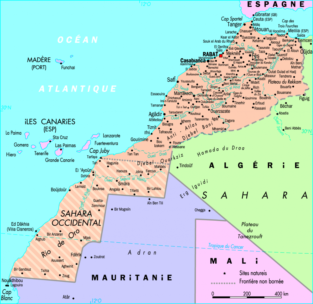
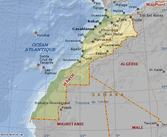
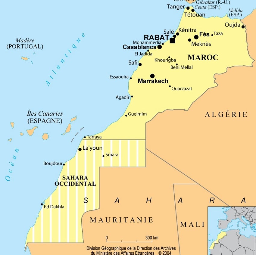
Located at the northwest tip of Africa, Morocco is bordered by the Atlantic Ocean to the west and the Mediterranean Sea to the north, and shares land borders with Algeria and the territories of Western Sahara.
The international telephone code for Morocco is +212 (or 00212).
| Element | Details |
|---|---|
| Official Name | Kingdom of Morocco |
| Capital | Rabat |
| Population | ~37–38 million inhabitants, strong coastal urbanization (Atlantic) |
| Area | ~446,550 km² (excluding Western Sahara) |
| Relief & Hydrography | Atlas Mountains (Middle, High, Anti-Atlas), Rif in the north, Atlantic plains, intermittent rivers, desert in the southeast |
| Climate | Mediterranean in the north, oceanic on the Atlantic coast, continental/mountainous in the Atlas, Saharan arid in the south |
| Major Cities | Casablanca, Rabat, Fès, Marrakech, Tangier, Agadir, Oujda |
| Languages | Arabic and Amazigh (official), widely used French, Spanish in the north |
| Currency | Moroccan Dirham (MAD) |
| Economy | Services, agriculture (citrus, olives), industry, tourism, phosphates |
| Points of Interest | Imperial medinas, Atlantic coasts, Atlas Mountains, valleys (Dadès, Drâa), Merzouga dunes, Chefchaouen |
| Access | Major airports (CMN, RAK, RBA, TNG, AGA), highway network, ONCF trains on main routes |
| Tips | Adapt itinerary to seasons (heat/deserts, snow in altitude), book accommodations in highly touristic cities |
Countries bordering Morocco
Morocco’s neighbors are Mauritania (southeast), Algeria (northeast), the Canary Islands (neighbors across the Atlantic Ocean), and Spain.
The Colors of Morocco
The flag of Morocco is an entirely red flag with a green pentagram (5-pointed star) in the center. The 5-pointed star represents the 5 pillars of the Muslim religion, which are prayer, faith, Ramadan, almsgiving, and the pilgrimage to Mecca.
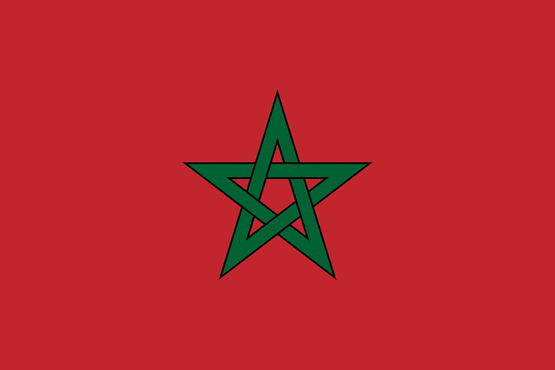
The green color of the star evokes hope and the color of Islam. The red color represents the Alaouite dynasty of the 17th century.
The best cities in Morocco
Rabat
Political capital of the country, Rabat stretches along the Atlantic Ocean, over nearly 60 km of coastline blending fine sandy beaches and rocky cliffs.
Bordered by the Bouregreg estuary, the city faces Salé, its twin city, hence its nickname “the twins”.
Listed as a UNESCO World Heritage Site, Rabat charms with its balance between modernity and authenticity. You can discover the royal palace, the Kasbah of the Oudayas, the Hassan Tower, and several administrative headquarters.
Its mild and sunny climate all year round makes it an ideal destination for visitors seeking culture and relaxation.
Casablanca
A true economic heart of Morocco, Casablanca is a dynamic metropolis where modernity and tradition coexist.
Its contemporary buildings, business centers, urban beaches, and its famous Hassan II Mosque testify to a Morocco looking towards the future.
It is also a popular seaside destination, animated by a cosmopolitan nightlife and a varied gastronomic offer.
Marrakech
Located at the foot of the High Atlas, Marrakech is one of the most emblematic cities of the country.
Nicknamed the “red city” for the color of its ramparts, it combines culture, history, and festivities.
Its souks, its famous Jemaa el-Fna square, its Majorelle Gardens, and its historic palaces make it a must-see.
Marrakech is also an ideal starting point to explore the mountains, valleys, and deserts of southern Morocco.
Fès
Former imperial capital, Fès is the spiritual and cultural cradle of Morocco.
Its medina, listed as a UNESCO World Heritage Site, is one of the largest and most authentic in the Arab world.
You can discover the Karaouiyine Mosque (one of the oldest universities in the world), beautifully decorated medersas (Quranic schools), and craftsmanship still practiced by hand.
It is a city where the past remains alive, between spirituality and age-old traditions.
Chefchaouen
Nestled in the Rif mountains, Chefchaouen fascinates travelers with its iconic blue streets and peaceful atmosphere.
It is an ideal place to stroll, photograph, or simply enjoy the calm and the Moroccan way of life.
The city also attracts hiking enthusiasts and lovers of Andalusian culture, thanks to its unique architecture and local craftsmanship.
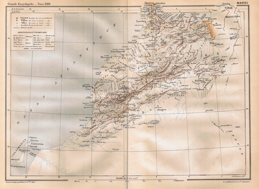
To organize your itinerary, rely on our resources dedicated to the country: discover the essentials with visiting Morocco, prepare your trip from A to Z via preparing your trip to Morocco, and get inspired by these spots not to miss under any circumstances to choose your stops.
Financial map of Morocco
The Moroccan economy is one of the most stable and diversified on the African continent. It is mainly based on international trade, industry, services, and agriculture.
Morocco is the world’s leading exporter of phosphates and its derivatives, a strategic sector that represents the main source of foreign currency for the country through the public group OCP (Office Chérifien des Phosphates).
Agriculture also retains an essential place in the national economy. The country notably exports citrus fruits, tomatoes, olives, horticultural products, and wine. However, this sector heavily depends on climatic conditions, particularly rainfall.
In recent years, Morocco has experienced sustained economic growth, driven by an ambitious industrialization policy (automotive, aeronautics, textiles, renewable energies). The development of free zones and logistics infrastructures (such as the Tanger Med port) strengthens its regional attractiveness.
Key economic data (2024-2025 estimates)
- Official currency: Moroccan Dirham (MAD)
- Nominal GDP: 132 billion USD
- GDP at purchasing power parity (PPP): 360 billion USD
- Annual GDP growth: approximately 2.7%
- Inflation rate: approximately 1.3%
- Population below the poverty line: approximately 15%
- Human Development Index (HDI): 0.676
- Active population: 45.8%
- Unemployment rate: approximately 9.4%
Thanks to its political stability, economic openness, and strategic geographical position between Europe and Africa, Morocco asserts itself as a major regional hub for investment and trade exchanges.
Climate map of Morocco
The climate of Morocco experiences several variations related to its geographical subdivisions
The Northern Atlantic Plains
This part of Morocco shows a Mediterranean climate strongly influenced by the marine breeze. The area is susceptible to oceanic disturbances coming from the Atlantic especially between October and May. The annual rainfall in this zone amounts to 810 mm. Temperatures, on the other hand, range between 12 and 13°C in winter and around 23°C in summer.
The interior plateaus
These parts of Morocco experience a varied continental climate, meaning there is an arid part located in the south and a cooler, more humid part in the north. Both sections of the territory have an average annual rainfall of 500 to 700 mm. Winter temperatures range between 9 and 13°C, but in summer, they range between 26 and 28°C.
The mediterranean coast and the rif
This part of Morocco features a Mediterranean climate. This climate is characterized by cool winters with temperatures between 9 and 12°C and hot, dry summers with temperatures ranging around 24 to 26°C. The annual rainfall in this part of Morocco is 700 to 1200 mm.
Saharan and Pre-Saharan area
This zone exhibits an arid-desert climate. It is characterized by rare or even nonexistent precipitation, around 50 to 61 mm annually. Winter temperatures hover around 3.8°C and 20.8°C, and in summer, temperatures range between 25.7°C and 44.3°C.
Demographic, demolinguistic and administrative map of Morocco

Demographics
The population of Morocco is estimated at around 37.4 million inhabitants in 2024, with a demographic growth rate of 0.95% per year.
The fertility rate stands at 2.1 children per woman, while the birth rate (around 17.5 ‰) remains higher than the death rate (around 4.9 ‰).
The life expectancy at birth reaches 77.3 years on average, slightly higher than the African average, with a sex ratio of about 96 men per 100 women.
The median age of the population is 29.7 years, reflecting a still young society but on the path to demographic maturity.
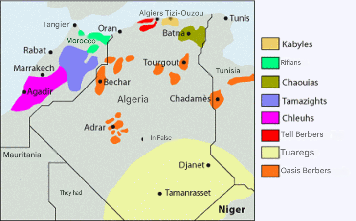
Ethnically, the Moroccan population is mainly composed of Berbers (Amazighs) and Arabs, representing about 85% of the total. The rest consists of Jewish, Sub-Saharan, and European minorities, mainly concentrated in large cities.
The dominant religion is Sunni Islam, practiced by more than 90% of the inhabitants, although Morocco also recognizes the historical presence of Jewish and Christian communities.
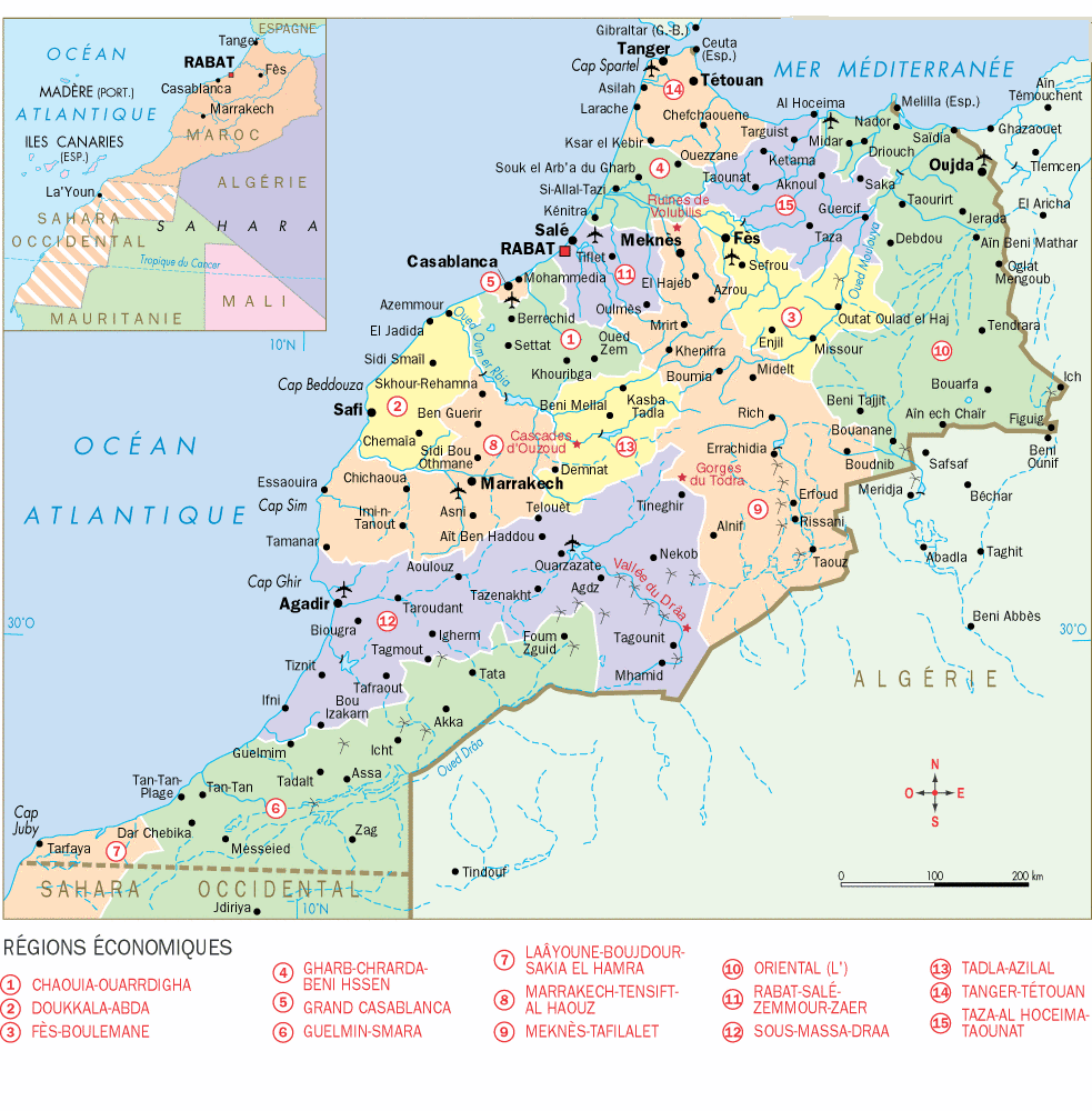
Administrative divisions of Morocco
The Moroccan territory is subdivided into 12 regions (Wilayas) which in turn are subdivided into 13 prefectures and 62 provinces. Finally, these are subdivided into 1,503 communes.
Here are the 12 regions of Morocco:
- Tanger-Tétouan-Al Hoceïma
- Oriental
- Fès-Meknès
- Rabat-Salé-Kénitra
- Béni Mellal-Khénifra
- Casablanca-Settat
- Marrakech-Safi
- Drâa-Tafilalet
- Souss-Massa
- Guelmim-Oued Noun
- Laâyoune-Sakia El Hamra
- Dakhla-Oued Ed-Dahab
Here are the prefectures and provinces of Morocco
Agadir Ida-Outanane
Al Haouz
Al Hoceïma
Aousserd
Assa-Zag
Azilal
Béni-Mellal
Benslimane
Berkane
Berrechid
Boujdour
Boulemane
Casablanca
Chefchaouen
Chichaoua
Chtouka-Aït Baha
Driouch
El Hajeb
El Jadida
Errachidia
Essaouira
Es-Semara
Fahs-Anjra
Fès
Figuig
Fquih Ben Salah
Guelmim
Guercif
Ifrane
Inezgane-Aït Melloul
Jerada
El Kelaâ s Sraghna
Kénitra
Khénifra
Khouribga
Laâyoune
Larache
Marrakech
M’diq-Fniq
Médiouna
Meknès
Mohammédia
Moulay Yaâcoub
Nador
Nord
Nouaceur
Ouarzazate
Oued Ed-Dahab
Ouezzane
Oujda-Angad
Milt
Rehamna
Safi
Séfrou
Settat
Sidi Bennour
Sidi Ifni
Sidi Slimane
Sidi Kacem
Sud
Tanger-Assilah
Tan-Tan
Taounate
Tarfaya
Taroudant
Tata
Taza
Tétouan
Tinghir
Tiznit
Youssoufia
Zagora
Demolinguistic data
Demolinguistic data of Morocco
Morocco has a rich linguistic diversity, reflecting its history and cultural mosaic.
The official languages of the country are Classical Arabic (or Modern Standard Arabic) and Amazigh (Berber), both recognized by the Moroccan Constitution of 2011.
However, in daily life, the majority of the population uses dialectal varieties:
- Moroccan Arabic (darija), spoken by about 69% of the inhabitants, is the most widely used language daily, especially in cities, media, and commerce.
- The Amazigh (Berber) languages include several regional dialects:
- Tachelhit (or chleuh): about 9.2% of speakers
- Tamazight (or Central Amazigh): about 7.6%
- Tarifit (or Rifain): about 4.0%
- Jebala Arabophone (mixed Arab-Berber influence from the north): about 3.4%
These languages are gradually taught in the education system and coexist in the media and public life.
French remains very present in administration, business, and higher education, while Spanish is commonly spoken in the north of the country, especially in Tétouan and Nador.
FAQ: Morocco Map
Opt for a Morocco Map showing highways, mountain roads, and access to valleys (Drâa, Dadès) to logically link Fès, Marrakech, and the dunes.
Yes, a Morocco Map with contour lines and major passes helps anticipate longer times on mountainous sections.
The Morocco Map combined with climates recommends spring/autumn for most routes, summer for the coast, and winter with caution at altitude.
Yes, rely on the Morocco Map to use rail (Al Boraq TGV and ONCF main lines) then rent a car locally for the valleys and the Atlas.
