
Lebanon is a country located halfway between Western Asia and the Middle East. It is also called the Lebanese Republic due to its status as a parliamentary constitutional republic. The capital and largest Lebanese city is Beirut.
Lebanon is a sovereign state located in the Middle East, with an area of approximately 10,452 km². Its population is estimated at around 5.3 to 5.6 million inhabitants (recent estimate, excluding refugee-related variations), placing it far from the top 20 most populous countries in the world.
Lebanon ranks around 160th in the world by area, making it a small-sized country, but not the smallest country in Asia (this title notably goes to the Maldives or Singapore depending on the criteria).
The telephone code for Lebanon is +961 (or 00961).
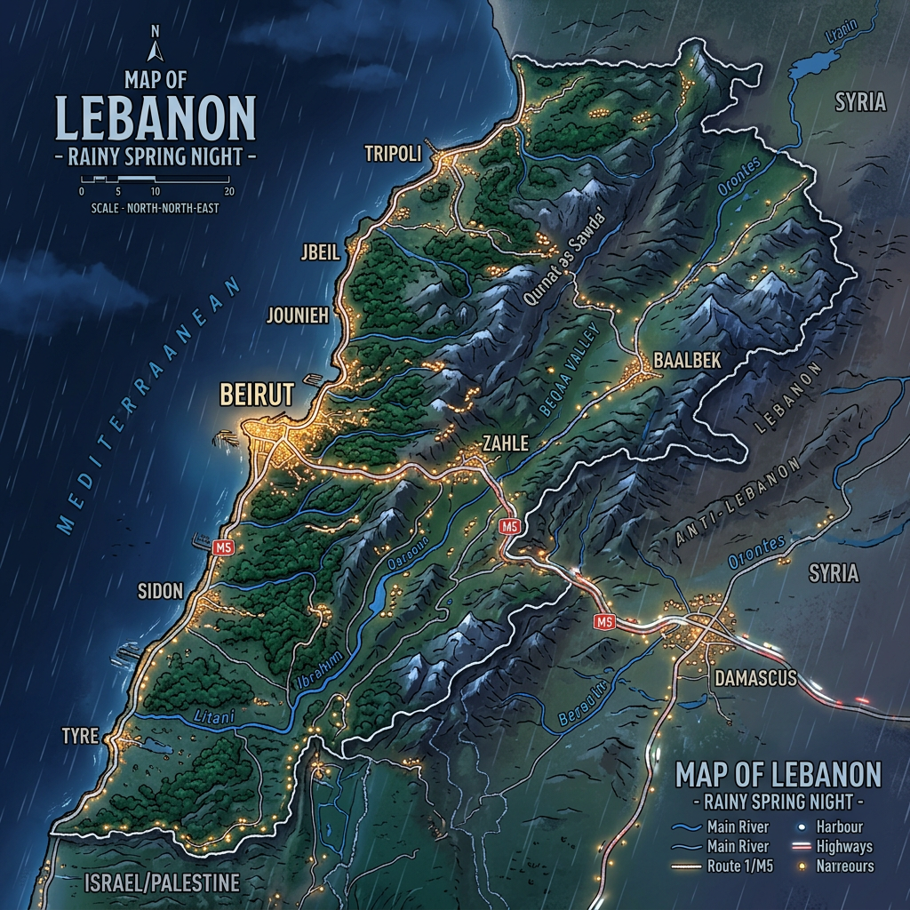
Map of Lebanon: key figures to read on the map
| Indicator | Key figure | Fun & useful reading |
|---|---|---|
| Total area | 10,452 km² | Smaller than Île-de-France |
| North ↔ South length | ≈ 225 km | Very elongated country |
| East ↔ West width | ≈ 80 km (max) | Mountains close to the sea |
| Estimated population | ≈ 5.3 million | High density |
| Average density | ≈ 500 inhabitants/km² | One of the highest in the region |
| Capital | Beirut | Political & economic center |
| Mediterranean coastline | ≈ 225 km | Continuous and urbanized coast |
| Highest point | Qurnat as Sawda – 3,088 m | Snow visible in winter |
| Mountain ranges | 2 main ones | Mount Lebanon & Anti-Lebanon |
| Dominant climate | Mediterranean | Hot summers, mild winters |
| Key agricultural zones | Bekaa Valley | Country’s agricultural breadbasket |
| Time zone | UTC+2 / UTC+3 | Eastern European Time |
Which countries border Lebanon?
Lebanon’s neighboring countries are Israel, Syria, and Cyprus (neighbor by the Mediterranean Sea).

Population of Lebanon
The population of Lebanon currently numbers 5,469,612 inhabitants, mainly composed of Syrians, Palestinians, and Iraqis with respectively 910,256, 470,000, and 5,700 inhabitants. The Lebanese population growth rate is -6.68%, and the birth rate is 0.136% and 0.54%.
The life expectancy of a Lebanese person at birth is 78.3 years, with 76.9 years for men and 79.8 years for women. The fertility rate is 1.72 children per woman. The male/female ratio is 105%, including 105% for those under 15 years old and 103% for those aged 15 to 64.
What are the colors of the country?

The Lebanese flag is a rectangular flag composed of 3 bands of two colors: The white band is bordered at the top and bottom by two red bands. The red bands are half the width of the white band. In the middle of the latter is the national symbol: the cedar of Lebanon.
- Red represents the Lebanese population and the battles for sovereignty
- White represents clarity and calm.
- The cedar is the national symbol
The best places to visit in Lebanon
Located between the Mediterranean and the mountains of the Middle East, Lebanon concentrates on a small territory an exceptional diversity of landscapes, historical sites, and vibrant cities, offering travelers a rare cultural and natural richness.
Meaningful distances (compact country)
| Route | Distance | Estimated time |
|---|---|---|
| Beirut → Tripoli | ≈ 85 km | 1h30 |
| Beirut → Baalbek | ≈ 85 km | 2h |
| Beirut → Sidon | ≈ 45 km | 1h |
| Beirut → Tyre | ≈ 85 km | 2h |
Sea + mountain + plain in the same day, unique at this scale.
Beirut
Beirut is the capital of Lebanon and the largest urban area in the country. It forms the political, administrative, and economic heart of the territory. A dynamic and cosmopolitan city, it houses many major cultural institutions, including the National Museum of Beirut, the Sursock Museum, and the Archaeology Museum of the American University of Beirut. The capital is also an important sports center, with iconic infrastructures such as the Camille Chamoun Sports City and the Beirut Municipal Stadium, which regularly host major regional events.
Tripoli
Tripoli is the second largest city in Lebanon and is located in the north of the country. It is one of the oldest cities in the territory, known for its rich historical and cultural heritage. A commercial and port city, Tripoli plays a key economic role thanks to its port, one of the main exchange and import-export points in the country. It also attracts visitors with its tourist sites, such as the Clock Tower and the Palm Islands Nature Reserve. Tripoli is also an important religious center, where mosques and churches coexist, and it has a well-developed educational and transport network.
Sidon
Sidon, the third largest urban area in Lebanon, is a city where modern architecture and historical remains blend. Marked by many civilizations, its past is still reflected today through its monuments and the artisanal know-how of its population, particularly in pottery and sculpture. Sidon also offers the amenities of a contemporary city, with shops, mosques, and churches. However, it retains a strong agricultural identity, especially around cereal cultivation, while facing environmental challenges related to air and coastal pollution.
Tyre
Tyre is one of the most iconic cities in Lebanon, with a population of about 135,000 inhabitants. An ancient Phoenician city founded around the third millennium BC, it was famous in antiquity for the production of purple dye, a symbol of power and nobility. Having come under Roman rule, the city today preserves significant archaeological remains that bear witness to these successive civilizations. Due to its exceptional historical and cultural value, much of Tyre is listed as a UNESCO World Heritage site.
Kobayat
Kobayat is a city renowned for its natural setting and lively atmosphere during the summer season. It stands out for the importance of its green spaces, among the largest in Lebanon, and for a pleasant climate that makes it a favored destination for visitors. Kobayat is also a place of religious pilgrimage, with many monasteries and churches scattered across its territory. Hiking enthusiasts find here a privileged starting point to explore the Lebanese mountains and reach the northernmost or southernmost regions of the country.
Where are the cities located on the map of Lebanon?

Beirut
On the map of Lebanon, the city of Beirut is located on the western coast of the country facing the Mediterranean. Geographic coordinates: 33° 53′ 23″ north, 35° 30′ 01″ east
Tripoli
On the map of Lebanon, the city of Tripoli is located in the western section of the country on the coast facing the Mediterranean; it is situated on the northernmost part of the western coast. Geographic coordinates: 34° 26′ north, 35° 50′ east
Sidon
On the map of Lebanon, the city of Sidon is located in the southern section of the country, on the western coast facing the Mediterranean. Geographic coordinates: 33° 33′ 38″ north, 35° 23′ 53″ east
Tyre
On the map of Lebanon, the city of Tyre is located in the southernmost part of the country; it is also situated on the Mediterranean coast. Geographic coordinates: 33° 16′ 08″ north, 35° 12′ 59″ east
Kobayat
On the map of Lebanon, the city of Kobayat is located inland in the northern tip of the country. Geographic coordinates: 34° 34′ 18″ north, 36° 16′ 53″ east
Climate map of Lebanon
According to the Köppen-Geiger classification, the Lebanese climate is characterized by a mild and less cold winter and a fairly hot but dry summer. Average temperatures during the summer periods hover around 22°C, while in winter, temperatures range between -3°C and 15°C. As one moves further into Lebanese territory, the climate becomes humid continental, with average annual temperatures around 18°C.
Some information characterizes the Lebanese climate as Mediterranean. Consequently, its winters are short and cool but its summers are long and dry. This climate is strongly influenced by the country’s topography, meaning it blends the aridity of the African continent with the humidity of Mediterranean regions.
The coldest periods mainly occur at the beginning of the year with temperatures ranging between 5 and 10°C; the driest periods are between 18 and 38°C with very sunny days and low relative humidity. During this period, temperatures can reach a maximum of 40°C and a minimum of 32°C. The dry periods are also influenced by the Sirocco, a dry wind coming from the southern part of the Middle East. These winds often bring sandstorms and are very violent.
Precipitation is brief and intermittent throughout the year. Almost all rainfall is concentrated between the months of November and March, with the driest periods between June and August. The rainy periods are not constant and can be accompanied by storms and floods, especially during the winter months.
Economic map of Lebanon
Lebanon has a developing economy, so the country is categorized as a middle-income country. Its nominal GDP was recently estimated at 54.1 billion dollars and its GDP per capita at 12,000 dollars. The strong economic growth Lebanon experienced was in 2006 when its annual growth rate reached 9.6%.

Lebanon has an economy historically based on services and the free market. It is classified as a middle-income country, but has been undergoing a major economic crisis for several years, considered one of the most severe in the world since the 19th century according to international institutions.
Before the crisis, Lebanon’s nominal GDP was around 54 to 56 billion dollars, with a GDP per capita above 12,000 dollars. The most notable growth period dates back to 2006, when the country recorded an exceptional growth of 9.6%.
Subsequently, growth slowed significantly, notably due to political instability, regional tensions, and structural dysfunctions, averaging around 1 to 2% until 2016.
Since 2019, the Lebanese economy has severely deteriorated. The country is now among the most indebted states in the world, with an extremely high public debt-to-GDP ratio. A very large portion of public revenues is absorbed by debt servicing, which greatly limits the state’s capacity to invest in infrastructure, public services, and social policies.
The service sector remains historically the pillar of the Lebanese economy, notably finance, trade, tourism, and real estate. The economic system, long open to foreign capital and characterized by free movement of funds, has encouraged the establishment of international companies and investors. Other sectors also play a notable role, such as banking, chemical industry, steelmaking, and textile manufacturing, although their activity has been heavily affected by the crisis. The main sources of foreign currency remain tourism, finance, and diaspora remittances.
Main economic indicators of Lebanon (recent estimates)
- Currency: Lebanese Pound (LBP)
- Nominal GDP: ≈ 56.3 billion USD
- GDP at purchasing power parity (PPP): ≈ 84.3 billion USD
- GDP growth rate: -6.3%
- GDP per capita (nominal): ≈ 9,250 USD
- GDP per capita (PPP): ≈ 14,700 USD
- Inflation: ≈ 17% (highly variable depending on the year)
- Population below the poverty line: ≈ 27% (low estimate, some sources mention higher)
- Human Development Index (HDI): 0.730
- Employment rate: ≈ 39.5%
- Unemployment rate: ≈ 6.2% (official figure, probably underestimated)
- Public debt: ≈ 74.5 billion USD
Administrative and demolinguistic data
Administrative subdivisions
Lebanon has 3 levels of territorial subdivisions. There are provinces (governorates) numbering 8, which are subdivided into districts (Cazas) numbering 26, and municipalities numbering 1029.
Here are the provinces of Lebanon:
- Akkar
- Baalbek-Hermel
- Bekaa
- Beirut
- North Lebanon
- South Lebanon
- Mount Lebanon
- Nabatieh
Here are the districts of Lebanon:
- Beirut
- Akkar (Halba)
- Baalbek (Baalbek)
- Hermel (Hermel)
- Baabda (Baabda)
- Aley (Aley)
- Metn (Jdeideh)
- Kesrouan (Jounieh)
- Chouf (Beiteddine)
- Jbeil (Byblos)
- Tripoli (Tripoli)
- Zghorta (Zghorta / Ehden)
- Bcharré (Bcharré)
- Batroun (Batroun)
- Koura (Amioun)
- Minieh-Denieh (Minieh / Syr Denieh)
- Zahlé (Zahlé)
- Rachaya (Rachaya)
- Western Bekaa (Joub Jenin)
- Sidon (Sidon)
- Jezzine (Jezzine)
- Tyr (Tyr)
- Nabatieh (Nabatieh)
- Marjayoun (Marjayoun)
- Hasbaya (Hasbaya)
- Bint-Jbeil (Bint-Jbeil)
Demolinguistic data
The ethnic majority in Lebanon are Lebanese Arabs who represent 70.1% of the country’s population. The ethnic minorities are Druze, Armenians, Alawites, Chaldeans, Arameans, Assyrians, and Jews, representing respectively 10.1%, 4.9%, 2.8%, 0.5%, 0.1%, and 0.05%.
Almost the entire population, 98%, speaks the Arabic language. The dialectal varieties are North Levantine Arabic, Lebanese Arabic, and Syro-Lebanese Arabic. The minority languages in the country are:
- Kurdish
- Armenian
- Syrian Arabic
- Egyptian Arabic
- Chaldean
- Neo-Aramaic
- French
- Iraqi Arabic
- Spanish
- Aramaic
- English
- Greek
- Italian
- Turkish
- Portuguese
- Neo-Aramaic Assyrian.
FAQ-Lebanon map: Practical information and country overview
Lebanon is located in the Middle East, bordered by the Mediterranean Sea to the west, Syria to the north and east, and Israel to the south.
Lebanon shares its borders with Syria to the north and east, and Israel to the south.
Lebanon is located in Asia.
