
Greece is a European country located simultaneously in the Balkans, the Mediterranean, and the Near East. Its borders lie in Europe, Asia, and Africa.
It has more than 2000 islands, of which only 170 are inhabited, and some are off the coast of the Aegean Sea, which is a few kilometers from Turkey. The total area of Greece is 50,949 square miles or 131,957 km2.

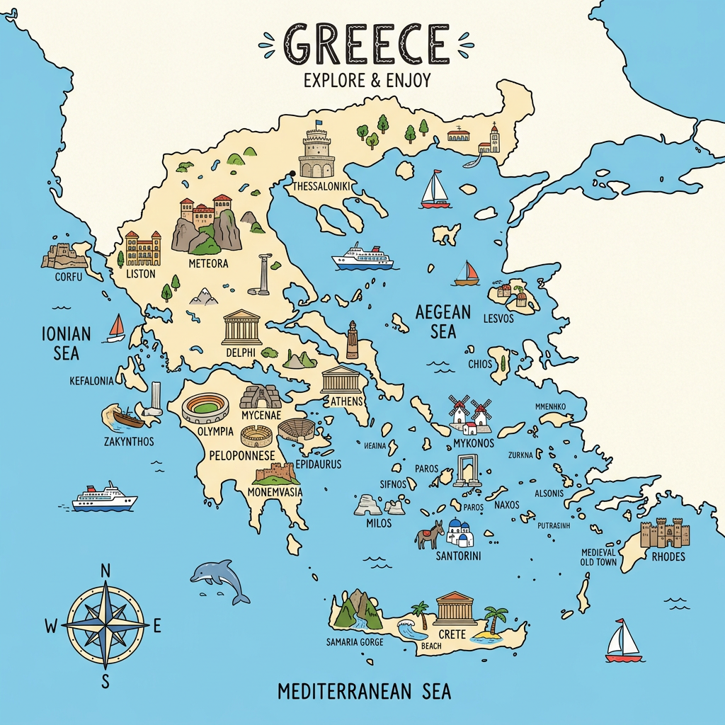
The capital of Greece is Athens. The country’s borders are the Aegean Sea to the East, the Mediterranean Sea to the South, and the Ionian Sea to the West. The land borders are to the north and northeast and measure 735,000 km. These borders are defined by Albania, North Macedonia, Bulgaria, and Turkey.
The Best cities in Greece
Greece is full of cities with exceptional historical heritage, idyllic beaches, and breathtaking landscapes. Whether you are passionate about history, a food lover, or seeking relaxation, here are 6 must-visit cities you absolutely cannot miss.
- Athens – Vibrant capital with 3.1 million inhabitants, Athens is the historical and cultural heart of Greece. Not to be missed: the Acropolis Museum, the 2,500-year-old Parthenon, the Temple of Zeus (one of the largest of Antiquity), the royal palace, and the Panathenaic Stadium which can hold 50,000 spectators.
- Corinth – An ancient city among the most powerful in the Greek world, Corinth charms with its sacred Temple of Apollo (dating from the 6th century BC), the ascent to the summit of Acrocorinth at 575 meters altitude, and its archaeological museum.
- Mycenae – Listed as a UNESCO World Heritage site, Mycenae houses the famous Lion Gate, the palace of Agamemnon, and beehive tombs over 3,000 years old. It also features impressive cyclopean walls.
- Epidaurus – Renowned for its ancient theater that can hold 14,000 spectators and for the Sanctuary of Asclepius, a major medical center of Antiquity.
- Olympia – Birthplace of the Olympic Games in 776 BC, Olympia preserves the remains of the temples of Zeus and Hera, as well as an ancient stadium where 45,000 people could watch sporting events.
- Santorini – Jewel of the Cyclades, Santorini is famous for its white houses with blue domes overlooking the Aegean Sea. The island offers spectacular beaches, some of the most beautiful sunsets in the world, and ancient ruins to explore.
The best attractions in Greece
| Attraction | Location | What Makes It Unmissable | Key Figures & Facts |
|---|
| Acropolis of Athens | Athens | Symbol of ancient Greece, housing the Parthenon and other remarkable monuments | Built in the 5th century BC, at 156 m altitude, welcomes over 3 million visitors per year |
| Sanctuary of Delphi | Delphi | Ancient religious center dedicated to Apollo, famous for its oracle | UNESCO listed, remains dating from the 8th century BC |
| The Meteora | Thessaly | Monasteries perched atop dizzying cliffs | 6 monasteries active out of the original 24, at more than 600 m altitude |
| Theatre of Epidaurus | Peloponnese | Ancient theatre renowned for its perfect acoustics | Built in the 4th century BC, 14,000 seats |
| Palace of Knossos | Crete | Largest Minoan archaeological site, linked to the myth of the Minotaur | Remains dating from 1900 BC, area of 20,000 m² |
| Temple of Poseidon | Cape Sounion | Breathtaking view of the Aegean Sea, site dedicated to the god of the sea | Built in the 5th century BC, columns 6 m high |
| Navagio Beach | Zakynthos | Iconic beach accessible only by boat | Cliff of 200 m and shipwreck dating from 1980 |
| Ancient Olympia | Peloponnese | Birthplace of the Olympic Games | First games in 776 BC, stadium with 45,000 seats |
| Monastery of Hosios Loukas | Central Greece | Masterpiece of Byzantine architecture | UNESCO listed, frescoes over 1,000 years old |
| Samaria Gorge | Crete | Legendary hike in the heart of a national park | Length of 16 km, cliffs of 500 m |
Where the cities are located on the map ?

Athens: On the map of Greece, Athens is located east of Mount Aegialea, south of Mount Parnes, and southwest of Mount Lycabettus. The geographical location is 37° 58′ 00″ NORTH, 23° 43′ 00″ EAST
Corinth: Corinth is located on the map on the Isthmus of Corinth situated on the strip connecting Greece to the Peloponnese. Geographical location 37° 56′ 00″ NORTH, 22° 56′ 00″ EAST
Mycenae: On the map, Mycenae is located between the Profitis Ilias and Zara mountains. The city is located northeast of the Argos plain. Geographical location: 37° 43′ 51″ NORTH, 22° 45′ 22″ EAST.
Epidaurus: Epidaurus is located on the map 10 km from the port city of Palea Epidavros. Geographical location: 37° 35′ 45″ NORTH, 23° 04′ 46″ EAST
Olympia: Olympia is located on the map to the right of the Alpheus River and about 18 km from the Ionian Sea. Geographical location: 37° 38′ 17″ NORTH, 21° 37′ 50″ EAST.
Santorini: Santorini is located in the South of the Aegean and on the map to the East of the Santorini archipelago. Geographical location: 36° 23′ 17″ NORTH, 25° 27′ 35″ EAST
Feel free to join the Facebook group about Greece!

Financial map of Greece
Greece is the 15th richest country and has the 34th GDP in the European Union. Greece’s economy is based on industry, services, and the agricultural sector which represents only 3%. Greece is also a very touristy country with more than 20 million people arriving from all over the world each year.
Here are some figures:
Currency: euro
Population: 10,701,000 inhabitants
Population ranking: 85
Density: 211 people per square mile or 81.5 inhabitants per km²
GDP 194,659,000,000 USD
GDP per capita 18,090 USD
Climate map of Greece

Greece has rather a Mediterranean climate marked by a very hot and dry summer and a wet and cold winter. Northern Greece is known to be very cold with a lot of snow. The South, on the other hand, has a milder winter with a large snowy part especially in the high mountains.
Temperatures in Greece vary between 30 and 40°C in summer. The whole country is subject to strong winds blowing from the north during the months of July and August.
Athens: Characterized by a mild winter during a short period of the year followed by cold and rainy weather that can turn into frost or snow.
Santorini: Characterized by an arid and hot climate from May to September and a cool winter. During the summer, average precipitation occurs throughout the period.
Coasts and islands: Characterized by a hot and sunny summer and a mild and rainy winter indicating a Mediterranean climate. The northern parts: Epirus, Macedonia, and Thessaly have a continental climate. This means a very cold winter that can be associated with frost and snow, and hot summers.
In the south, the Mediterranean climate is characteristic of a mild and rainy winter in the Ionian Islands and the Dodecanese (islands close to Turkey).
North of Greece
Thessaloniki
Located in the North, Thessaloniki is a city with a continental climate. That means the temperature is somewhat cold in winter with occasional precipitation. From July to August, however, the summer is hot.
Florina
It is also a city located in the north with a Mediterranean climate characterized by very hot summers during the day and cool nights.
Center-south
The center (Dodecanese, Crete, Kythira, the southern Cyclades islands and the Ionian islands) has a Mediterranean climate. It is characterized by mild and rainy winters and hot, sunny summers.
South
The South is characterized by mild winters with occasional cold spells. Summer, on the other hand, is not as hot as in Athens because the sea winds blow a lot.
Demographic and administrative map of Greece

Demographics of Greece
The Greek population is 10,934,080 inhabitants with a ratio of 49.51% men and 50.49% women. The life expectancy of the Greek population is 78.9 and 84 respectively for men and women.
In Greece, immigration is common, which has led to growth in the urban population. Rural areas, on the other hand, have become depopulated. The birth rate has also dropped significantly by -10% according to hospitals.
Administration of Greece
Greece is subdivided into 13 regions also called administrative divisions. Greece is also divided into a peninsula called mainland Greece and several islands in the Aegean Sea. Here are the different regions:
- Attica
- Crete
- South Aegean Sea
- North Aegean Sea
- Epirus
- Central Greece
- Western Greece
- Ionian Islands
- Central Macedonia
- Western Macedonia
- Eastern Macedonia and Thrace
- Peloponnese
- Thessaly
Linguistic demographic map of Greece
Greece has always been a very cosmopolitan country which has allowed it to develop a more or less uniform language with some divergences:
Attic-Ionic dialect: An ancient dialect spoken by Athenians and Ionians from the Aegean Sea and the coasts of Turkey.
Aeolic dialect: This is the dialect spoken by the Greeks of the northern and central Aegean Sea islands.
Arcado-Cypriot dialect: It is a Cypriot dialect spoken by prehistoric Mycenaeans.
Doric dialect: It is a dialect used by the ancient Greeks of the Peloponnese.
Koine dialect: It is the dialect that is the origin of common Greek.
FAQ-Greece map: Geographical and demographic information
Greece is located in southeastern Europe, at the southern tip of the Balkan Peninsula, and is bordered by the Ionian Sea to the west, the Aegean Sea to the east, and the Mediterranean Sea to the south.
Greece shares its land borders with Albania to the northwest, North Macedonia and Bulgaria to the north, and Turkey to the east.
Greece is located in Europe.
