
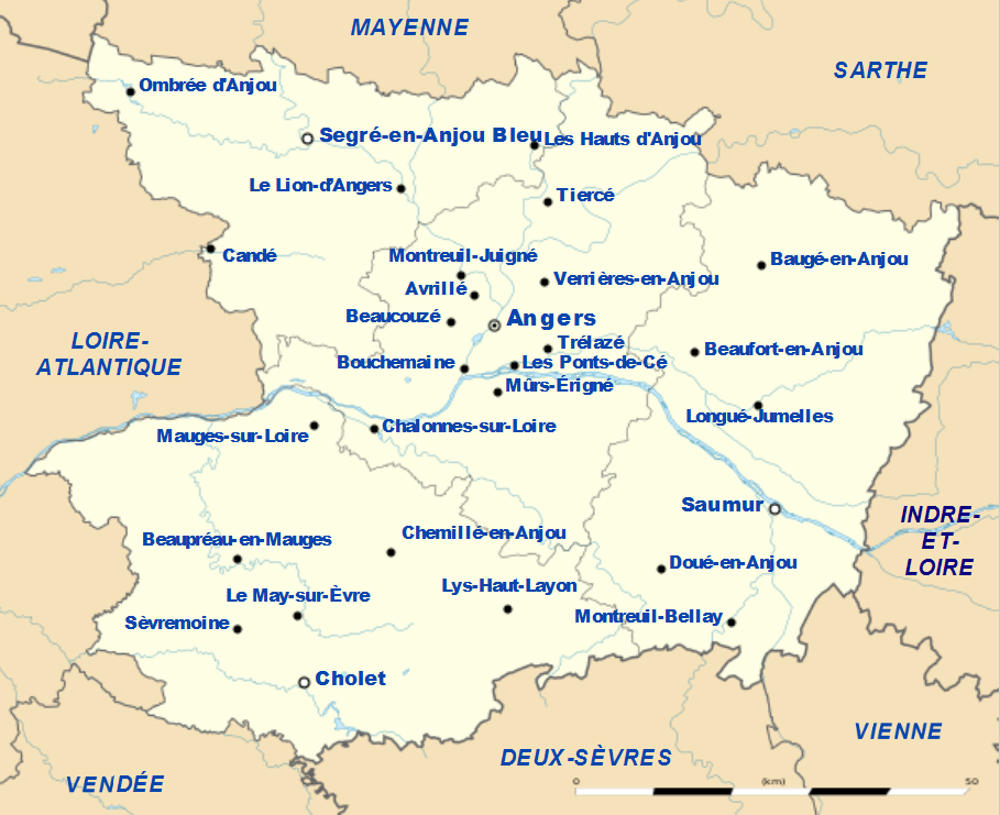
What you need to know about Maine-et-Loire ?
Here we present to you the 49th department of France, which is administratively divided into 363 communes, 41 cantons, and 4 arrondissements. In fact, it is a department that is part of the Pays de la Loire region; it is a landlocked department, meaning it has no access to the sea. It is also a very old department of France, created in 1790, with boundaries that were those of the province of Anjou dating back before 1790.
The area of this department is 7,166 km², making it the 26th largest French department by area. In addition, the Angevins currently number 834,654 inhabitants, resulting in a population density of approximately 116 inhabitants per km².
This department is a rural one, so its economy is mainly based on agriculture and livestock farming. Its urban center, prefecture, and at the same time the largest city and administrative capital, is Angers. Furthermore, its sub-prefectures are: Cholet, Segré-en-Anjou Bleu, and Saumur.
Economically, it is the second most important industrial center in the Pays de la Loire region, mainly because of the very famous Maine-et-Loire vineyard. Moreover, geographically, there are two places classified as UNESCO World Heritage sites in the department: the Loire Basin and the natural region of the Loire Valley. Finally, the territory of the Maine-et-Loire department is heavily traversed by many tributaries.

Which departments border the Maine-et-Loire department?
In reality, there are 8 departments neighboring the Maine-et-Loire department, and these 8 departments belong to 3 regions:
In the Nouvelle-Aquitaine region, there is the Deux-Sèvres department; in the Centre-Val-de-Loire region, there is the Indre-et-Loire department. Then, in the Pays de la Loire region, there is the Loire-Atlantique department; and finally, in the Brittany region, there is Ille-et-Vilaine. Within the same region, there are Mayenne, Sarthe, and Vendée.
What is the climate like in the Maine-et-Loire department?
Actually, the climate of Maine-et-Loire is temperate, but it is somewhat between an Atlantic climate and an oceanic climate. Moreover, this so-called climate is diverse when talking about the different areas of the department, that is to say in the Loire valley zones and certain natural regions.
When discussing the climate of Maine-et-Loire, it is seen as a transitional climate type. It is influenced by the ocean on the part facing the Atlantic. The continental influence is strongly felt when moving inland. There is also the fact that on the department’s reliefs, the climate is somewhat different.
In the western part of the Maine-et-Loire department, the territory is very dry during the summer period. On the other hand, in the west, there is a lot of limestone, making it somewhat more humid throughout the year. Thus, the western part of the said department is mostly more humid due to the Atlantic. But conversely, for the eastern part of the department, there is an average of 120 rainy days, and for the mountains, there are about 165 rainy days per year.
What are the most important cities in the Maine-et-Loire department?
Here we present to you the top 10 rankings of the largest and most populated cities in the 49th department, which is Maine-et-Loire.
- Angers,
- Avrillé,
- Cholet,
- Doué-la-Fontaine,
- Les Ponts-de-Cé,
- Longué-Jumelles,
- Saint-Barthélemy-d’Anjou,
- Saumur,
- Trélazé,
What are the largest municipalities in the Maine-et-Loire department
To make this ranking, we referred to the area of each of the municipalities in the Maine-et-Loire department
- Segré-en-Anjou Bleu
- Ombrée d’Anjou
- Longué-Jumelles
- Saumur
- Durtal
- Beaupréau-en-Mauges
- Mauges-sur-Loire
- Cholet
- Val d’Erdre-Auxence
- Lys-Haut-Layon
In the current second ranking of the municipalities of Maine-et-Loire, we grouped them according to the density of inhabitants per km2.
- Angers
- Saumur
- Mauges-sur-Loire
- Avrillé
- Les Ponts-de-Cé
- Cholet
- Beaupréau-en-Mauges
- Segré-en-Anjou Bleu
- Trélazé
- Ombrée d’Anjou

FAQ – Maine-et-Loire map
A Maine-et-Loire map helps locate the department’s main cities, roads, and administrative boundaries. It also provides an overview of valleys, rivers, vineyards, and neighboring municipalities.
A map is useful for planning a trip, organizing a route, or locating a place of interest. It also helps users better understand the department’s geography and territorial organization.
A detailed Maine-et-Loire map is available in printed form from certain organizations or in digital format on various specialized platforms. It may include municipalities, road networks, landforms, and the department’s main points of interest.
