
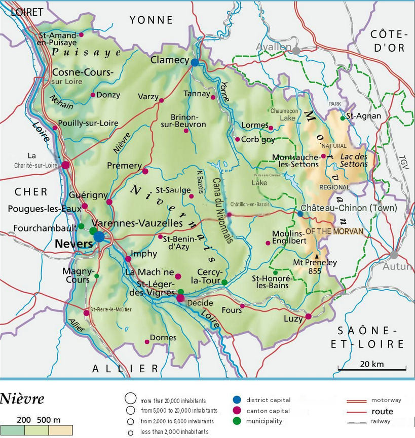
What you need to know about the Nièvre department ?
We are here to introduce you to a division called Nièvre, a department located in the southwest of the Bourgogne-Franche-Comté region in France, which takes its name from the stream that runs through it. During the French Revolution on March 4, 1790, its territory was defined by the former Nifnay law of December 22, 1789.
Note that initially, the department was given the name “Nyèvre”. Probably the oldest department in France, the 58th with Nevers as its capital, which is also its prefecture. The territorial divisions are Cosne-Cours-sur-Loire, Clamecy, or Château-Chinon.
The inhabitants of the 58th department, Nièvre, are known as Nivernais. The department currently has 198,355 inhabitants, and its total area covers 6,817 square kilometres. This corresponds to a population density of 29 inhabitants per square kilometre.

What are the neighboring departments of Nièvre?
Division 58 being a fundamental part of Bourgogne-Franche-Comté, it is located in the territory of the former Nivernais region. Its adjoining departments are the departments of Côte-D’Or, the department of Loiret, the department of Allier, the department of Yonne, the department of Saône-et-Loire, the department of Cher.
What is the climate like in the Nièvre department
The climatic nature of Nièvre is located at the junction of maritime, continental, and southern effects. On the west side, the climate is softened oceanic type. The central area is more mixed: The Morvan has a mid-mountain climate with abundant precipitation, cold winters, and cool summers. At altitude and in the mountains (500-600m), the climate is colder and less familiar than in Morvan. At lower levels, the tones mix depending on conditions. Further north, the semi-continental climate prevails.
Thus, the climatic type of Nevers is degraded maritime with a strong continental effect in the Loire and Allier area. This results in cool winter nights and warm days in mid-year.
Three particular climatic zones are found in department 58.
- Two have a degraded oceanic type, including the domain of Nivernais and Sologne.
- Then, there is a mountain-type environment at altitude.
- In the plain, at the meridian of Morvan, the marine climate is modified.
The highest temperature in Nevers (Nièvre) hovers around 16°C throughout the year (from 7°C in January to 26°C in August). Rainfall amounts to 713 mm over the year, with about 40 mm in September and 83 mm in May. The climate is delightful for holidays in Nevers from May to September, but the climatic conditions are truly ideal in August. Generally, the hottest months are July and August, the coldest months are January and February, the windiest months are May, June, and December.
What are the most important cities in Nièvre?
Here we present to you the most important cities in terms of tourist attendance. That is, this list of 10 cities I present to you are cities with strong tourist appeal:
- Nevers
- Château-Chinon
- Saint-Amand-en-Puisaye
- Decize
- La Charité-sur-Loire
- Saint-Honoré-les-Bains
- Bazoches
- Clamecy
- Coulanges-lès-Nèvers
- Vitry-Lâche
What are the most important municipalities in the Nièvre department?
To make this ranking, we referred to the size of each municipality in the Nièvre department.
- Donzy
- Arleuf
- Lucenay-lès-Aix
- Cervon
- Lormes
- Ouroux-en-Morvan
- Entrains-sur-Nohain
- Brassy
- Cosne-Cours-sur-Loire
- Cossaye
Regarding this second ranking of the municipalities of Nièvre, we grouped them according to the density of inhabitants per km2.
- Nevers
- Varennes-Vauzelles
- La Charité-sur-Loire
- Clamecy
- Garchizy
- Cosne-Cours-sur-Loire
- Decize
- Fourchambault
- Imphy
- La Machine

FAQ – Moselle map
A Moselle map helps locate the department’s main cities, roads, and administrative boundaries. It also provides an overview of valleys, rivers, natural areas, and neighboring municipalities.
A map is useful for planning a trip, organizing a route, or locating a place of interest. It also helps users better understand the department’s geography and territorial organization.
A detailed Moselle map is available in printed form from certain organizations or in digital format on various specialized platforms. It may include municipalities, road networks, landforms, and the department’s main points of interest.
