
What You Need to Know About Benin
Benin is a country in West Africa, officially called the Republic of Benin.
- Its area is 114,764 km², crossed in the north by about 700 km of the Niger River.
- Its population is estimated at about 13.7 million inhabitants in 2025.
- Benin is thus the 102nd largest country in the world and the 74th most populous.
The political capital is Porto-Novo, while the economic capital and largest city is Cotonou.
The international telephone code is +229 (00229).
Table – Benin: Geographical and Demographic Information
| Element | Key Information |
|---|---|
| Total area | 112,622 km² |
| Political capital | Porto-Novo |
| Economic capital | Cotonou |
| Neighboring countries | Togo, Burkina Faso, Niger, Nigeria |
| Coastline | ~125 km on the Atlantic Ocean (Gulf of Guinea) |
| Estimated population | ~14.5 million inhabitants (2025) |
| Population density | ~129 inhabitants/km² |
| Relief | Coastal plains, central plateaus, savannas in the north |
| Climate | Equatorial in the south, tropical in the north |
| Official language | French |
| Economic resources | Cotton, cashew, agriculture, port of Cotonou |
| Particularity | Narrow country from the Gulf of Guinea to the Sahel, West African crossroads |
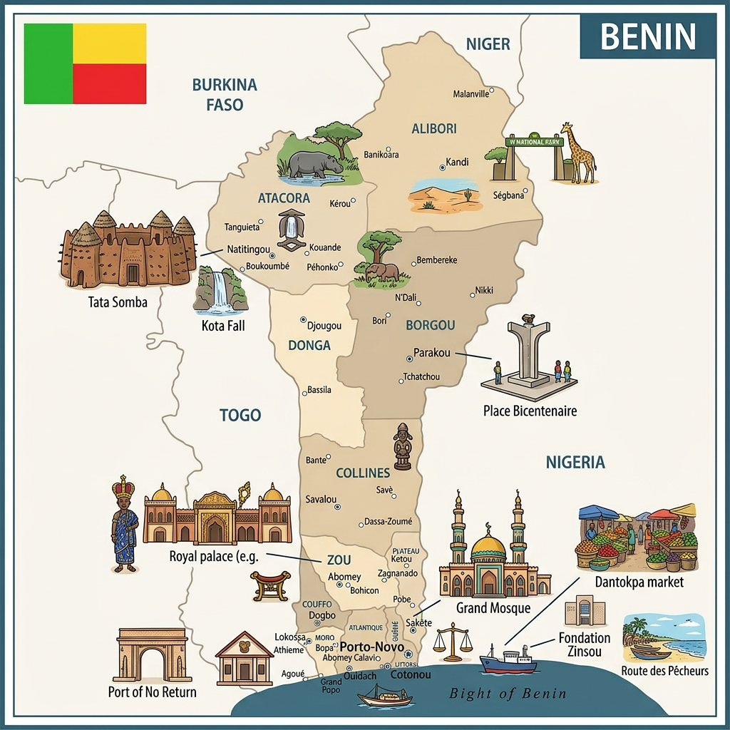
Additional Points on the Map of Benin
- Located in West Africa, Benin is an elongated country from the Gulf of Guinea to the Niger.
- Its physical map shows coastal plains, a central plateau, and savannas in the north.
- It shares its borders with Togo, Burkina Faso, Niger, and Nigeria.
- Porto-Novo is the official capital, but Cotonou is the economic and political heart.
- Benin is recognized as the birthplace of the Kingdom of Dahomey and voodoo.

Benin’s Neighboring Countries
Benin’s neighboring countries are Togo, Nigeria, Niger, and Burkina Faso, which border it respectively to the west, east, north-northeast, and north-northwest. In total, Benin’s borders measure 2,123 km, including 386 km with Burkina Faso, 277 km with Niger, and 809 and 651 km for Nigeria and Togo respectively.
The Colors of Benin
The national flag of Benin is a rectangular flag made up of 3 colors. Near the hoist, there is a vertical green band, and towards the fly side, a superposition of horizontal yellow and red bands.

- The color red evokes the bravery of the ancestors
- The color yellow symbolizes the treasures of the nation
- The color green evokes the hope for a nonconformist democracy.
These three colors represented on the flag also illustrate a Pan-Africanist movement.
The map of Benin highlights a country in West Africa, bordered by Togo to the west, Burkina Faso and Niger to the north, as well as Nigeria to the east. Its coastline on the Gulf of Guinea and its port of Cotonou make it a regional economic hub.
The Best Cities in Benin

Cotonou
Economic capital and largest city of the country, Cotonou is a blend of modernity and African culture. You can find there:
- beautiful beaches lined with coconut trees,
- the Pendjari Reserve, one of the most beautiful wildlife reserves in West Africa,
- the famous fetish market, known for its products related to Vodou practices.
Porto-Novo
Political capital of Benin, Porto-Novo still retains traces of its Portuguese and French colonial past. Visitors can discover there:
- the ethnographic museum,
- the Honmé Museum (Museum of the Kings of Dahomey),
- botanical gardens and remarkable colonial buildings.
Ouidah
A city rich in history, Ouidah was a center of the slave trade and holds a strong memory of this period. You can visit there:
- the Slave Route and the Door of No Return,
- museums dedicated to the history of slavery and Vodou,
- as well as its magnificent beaches.
Abomey
Former capital of the Kingdom of Dahomey, Abomey is a major historical site listed as a UNESCO World Heritage site. Its attractions include:
- the royal palaces of Abomey,
- museums tracing the history of the kings of Dahomey,
- and traditional craft workshops.
Natitingou
Located in the northwest of the country, Natitingou is an essential stop to explore the Pendjari National Park. You can also find there:
- the regional museum of Natitingou,
- traditional villages with fortified huts,
- and picturesque landscapes between hills and savannas.
Financial Map of Benin
Benin remains a developing country, whose economy mainly relies on:
- subsistence agriculture (beans, rice, cassava, peanuts, pineapples, cocoa),
- cotton cultivation, which represents nearly 40% of GDP and 80% of exports,
- a limited industry (palm oil refining, cocoa processing, textiles),
- and a growing fishing sector.
Economic Data (2025)
- Currency: West African CFA franc (XOF)
- Nominal GDP: ~18 billion USD
- GDP (PPP): ~55 billion USD
- GDP Growth: ~6% per year
- GDP per capita (nominal): ~1,350 USD
- GDP per capita (PPP): ~4,100 USD
- Population below poverty line: ~38–40% (down from 49% ten years ago)
Climate Map of Benin
Benin has a hot and humid tropical climate with an annual rainfall of 1360 mm. Rainfall is abundant especially along the western coasts. Rain generally occurs between April and July. The dry season, on the other hand, lasts from December to April with a temperature drop between July and September.
The hottest areas are along the coasts. This includes the economic capital which averages 31°C maximum temperature and 24°C average temperature. The northern regions show temperatures higher by 10°C, reaching 41°C in the Sahel due to the Harmattan, a Sahara wind that blows between December and March.
Demographic and Administrative Map of Benin

Demographics of Benin
The population of Benin is estimated at approximately 13.7 million inhabitants in 2025.
- Fertility rate: 4.7 children per woman
- Median age: 18.1 years → very young population
- Population growth rate: ~2.7% per year (16th highest in the world)
- Urbanization rate: ~47% of the population lives in cities
- Sex ratio: ~105 men per 100 women
- Life expectancy: ~63 years (61 years men, 65 years women)
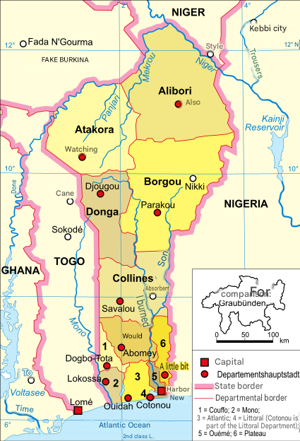
Administrative Map of Benin
The Beninese territory is subdivided into:
- 12 departments
- 77 communes
- 546 arrondissements (and not 84 districts — correction of the current administrative terminology).
The 12 Departments of Benin
- Alibori
- Atakora
- Atlantique
- Borgou
- Collines
- Couffo
- Donga
- Littoral
- Mono
- Ouémé
- Plateau
- Zou
Examples of Communes in Benin
- Alibori: Banikoara, Gogounou, Kandi, Karimama, Malanville, Ségbana
- Atakora: Boukoumbé, Cobly, Kérou, Kouandé, Matéri, Natitingou, Péhunco, Tanguiéta, Toucountouna
- Atlantique: Abomey-Calavi, Allada, Kpomassè, Ouidah, Sô-Ava, Toffo, Tori-Bossito, Zè
- Borgou: Bembèrèkè, Kalalé, N’Dali, Nikki, Parakou, Pèrèrè, Sinendé, Tchaourou
- Collines: Bantè, Dassa-Zoumè, Glazoué, Ouèssè, Savalou, Savè
- Donga: Bassila, Copargo, Djougou, Ouaké
- Couffo: Aplahoué, Djakotomey, Klouékanmè, Lalo, Toviklin, Dogbo
- Littoral: Cotonou (the only commune of the department)
- Mono: Athiémé, Bopa, Comé, Grand-Popo, Houéyogbé, Lokossa
- Ouémé: Adjarra, Adjohoun, Aguégués, Akpro-Missérété, Avrankou, Bonou, Dangbo, Porto-Novo, Sèmè-Kpodji
- Plateau: Ifangni, Adja-Ouèrè, Kétou, Pobè, Sakété
- Zou: Abomey, Agbangnizoun, Bohicon, Covè, Djidja, Ouinhi, Zagnanado, Za-Kpota, Zogbodomey
Demolinguistic Data of Benin
According to the United Nations demolinguistic data, the Beninese are divided into several ethnic groups with different dialectal varieties (about 60)
The most dominant groups in the southern section are the Fons and the Adjas. In the northern section, they are the Baribas and the Sombas. Here are the ethnic groups of Benin by region:
South-West:
Adjas
- Ouatchis
- Guins
- Houédas
- Houlas
South
- Fons
- Aïzos
- Holis
- Toffins
South-East
- Gouns
- Yorubas
Center
- Fons
- Mahis
- Yorubas
North and Northeast
- Batombus
- Dendis
- Fulbés
Northwest
- Bétamaribés
- Waabas
- Yowas

The official language of Benin is French, spoken by more than 36% of the population. However, the native Beninese language consists of more than 60 dialectal varieties. But the most dominant dialects are: Fon, Yoruba, Bariba, Adja, Goun, and Aïzo, which represent respectively 17.6%, 8%, 7.9%, 6.2%, and 3.9%.
FAQ – Benin map: 3 questions
Benin is in West Africa, between Togo, Burkina Faso, Niger, and Nigeria, with an opening onto the Atlantic Ocean.
The official capital is Porto-Novo, but the economic capital and largest city is Cotonou.
The country stretches from the Atlantic coast in the south to the savannas in the north, with varied relief between plains and plateaus.
