
Exploring Botswana through various geographical maps helps to better understand the diversity of this Southern African country. Located in the heart of the continent, Botswana offers a unique panorama between desert, savanna, and aquatic riches. Whether you are passionate about the map of Botswana, a travel enthusiast, or simply curious, taking an interest in the cartographic representations of Botswana helps grasp the structure of its territory, its population, as well as its natural specificities.
Whether it is choosing a road map to prepare a journey, studying the tourist map, or visualizing the borders and neighboring countries, each type of map provides essential information. Here is a detailed overview of the different cartographic tools that shape the face of Botswana today.
General presentation of Botswana on the map
| Element | Key information |
|---|---|
| Total area | 581,730 km² |
| Capital | Gaborone |
| Bordering countries | South Africa, Namibia, Zimbabwe, Zambia |
| Estimated population | About 2.7 million inhabitants (2025) |
| Population density | ~5 inhabitants/km² (low) |
| Relief | High plateaus, Kalahari Desert, savanna areas |
| Climate | Semi-arid to subtropical |
| Official languages | English, Setswana |
| Natural resources | Diamonds, copper, nickel, coal |
| Main cities | Gaborone, Francistown, Maun, Selebi-Phikwe |
Botswana is located in the far south of Africa, landlocked between several nations. A geographical map immediately shows its precise location as well as the main physical characteristics of the region. On a map of Botswana, one quickly recognizes its vast arid zones, dotted with seasonal rivers and a significant inland delta.
Physical maps also reveal distinctive elements such as the Kalahari, which occupies a large part of the territory. Other areas, such as the Okavango Delta, appear clearly in physical representations, highlighting a mosaic of exceptional natural environments, sometimes difficult to access without good cartographic preparation.
Additional points on the map of Botswana
- The Okavango Delta, listed as a UNESCO World Heritage site, is visible on the map as an oasis in the heart of the Kalahari Desert.
- The country is landlocked (without access to the sea), surrounded by four African nations.
- Botswana is one of the most sparsely populated countries in the world relative to its area.
- Its economic map reflects a strong dependence on diamond mines.
- The territory hosts vast wildlife reserves, notably Chobe National Park and the Central Kalahari Game Reserve.
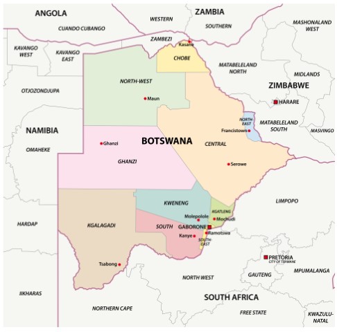
Territorial boundaries: borders and neighboring countries
Looking at Botswana through an administrative map highlights the national borders and the country’s direct neighbors. Botswana shares its boundaries with four other countries, each playing a particular role in the movement of goods and people in the region.

Understanding the border lines is essential, especially for those planning cross-border travel or wishing to learn more about regional dynamics. Most maps used in education or during travels present this information clearly and intuitively.
- To the north: Botswana borders Zambia and Zimbabwe over short distances, offering strategic crossing points.
- To the east and southeast: the country shares a long border with South Africa, its main economic partner.
- To the west and northwest: Namibia largely borders Botswana, contributing to the dynamics of the Trans-Kalahari corridor.
Internal organization: regions and districts of Botswana
An administrative map of Botswana clearly distinguishes the different territorial management units called “districts.” These divisions are essential not only for territorial administration but also for census, natural resource management, and local development.
By exploring the main administrative subdivisions on the map, it becomes easy to understand how the country is organized politically and economically. There are twelve main districts, each with a capital town that handles local administrative functions.
- Rural districts: they cover most of the area, often hosting Botswana’s essential natural reserves.
- Urban regions: these correspond notably to the capital Gaborone as well as other major cities, concentrating a large part of the national population.
What are the major urban centers and capitals?

Maps highlighting cities and capitals emphasize the centrality of Gaborone, located near the southeast border. This city plays a crucial role in Botswana’s political, economic, and social life. Francistown, Maun, and Selebi-Phikwe are also among the country’s important cities.
Maun especially attracts travelers as it serves as the gateway to the Okavango Delta. Urban representations on maps help plan efficient travel while perceiving Botswana’s relatively modest urban scale compared to some African neighbors.
How to recognize internal borders on a map?
On an administrative map, each district is precisely delineated. This territorial organization helps easily locate the seats where local political decisions are made. Many maps also reproduce the main roads connecting these vital centers, facilitating anticipation of inter-district journeys.
Organization by districts also provides valuable information on population distribution, economic activities, and protected areas. Any map showing these subdivisions thus allows a quick reading of Botswana’s overall administrative structure.
The map of Botswana shows a landlocked country in the heart of Southern Africa. It shares its borders with Namibia to the west, South Africa to the south, Zimbabwe to the east, and has a short border to the north with Zambia.
Diversity of Botswana maps according to needs
Different formats exist to meet the varied expectations of users. To adapt to all profiles, several types of Botswana maps are commonly offered, each presenting targeted and complementary information.

From the simple practical plan to the detailed representation of the relief, the choice of map depends entirely on the objectives sought: travel, tourist exploration, academic analysis, or landscape discovery.
What is a Botswana road map used for?
The road map remains essential for efficiently traveling across the country. It indicates the major routes, often paved, but also the secondary tracks leading to less frequented places. Locating fuel depots, checkpoints, and isolated villages greatly facilitates the organization of an independent trip.
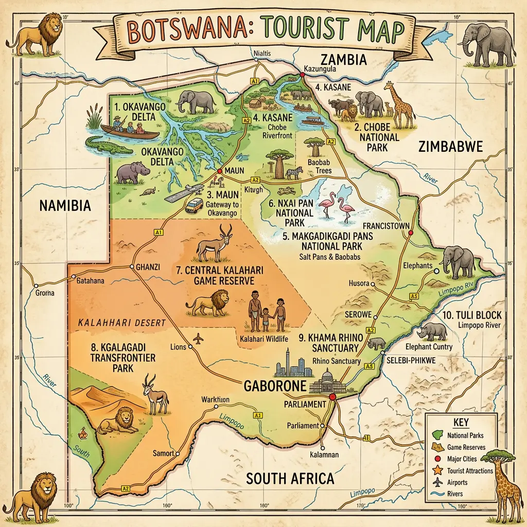
For example, many travelers use a road map to plan their expedition in the vast Chobe National Park or to reach the remote banks of the Makgadikgadi Pans. Knowing the condition of the roads is among the essential criteria in developing a safe itinerary.
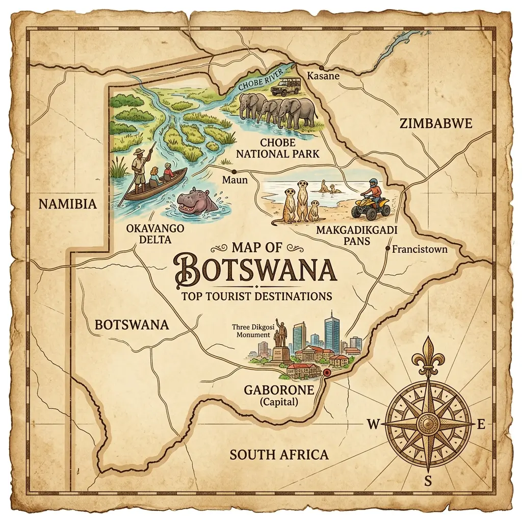
Why consult a Botswana tourist map?
Ideal for turning dreams into reality, the Botswana tourist map highlights emblematic sites, national parks, wildlife reserves, accommodations, and notable cultural attractions. Thanks to this representation, visualizing the ideal route or preparing a nature getaway becomes more accessible.
Many visitors trust the tourist map to connect at a glance the major points of interest: safari in the Okavango, cruise on the Chobe River, visit to Tsodilo Hills… So many experiences, all showcased thanks to an attractive and educational map.
What are the advantages of a physical or geographic map?
Exploring Botswana using a physical map offers a better understanding of the relief and topography. This format faithfully represents mountains, hills, valleys, rivers, and desert expanses. It then becomes easier to appreciate the variety of landscapes between the central basin, the southern plateaus, and the lush basins of the north.
The geographic map often complements this panorama by displaying vegetation nuances, hydrographic networks, as well as climatic particularities specific to each area. This type of document is essential for researchers, teachers, or enthusiasts wishing to discover the layout of the Botswana territory in all its aspects.
Reading and using a Botswana plan: practical advice
Approaching Botswana with the help of a map requires knowing its legend, scales, and specific conventions. Being able to read these documents ensures safe navigation, whether during urban excursions or in the wild bush. Handling a reliable map also promotes discoveries off the beaten path.
To make the most of each map, always identify the symbols dedicated to borders and neighboring countries, cities and capitals, and regional administrative boundaries. These markers simplify interpretation even for those less familiar with African cartography.
- Carrying a paper map when traveling in isolated areas helps avoid electrical or digital mishaps.
- An interactive digital map offers the advantage of frequent updates, particularly useful during road trips or visits to national parks.
- Combining a road map and a tourist map provides a comprehensive overview of the route to be taken and the cultural stops not to be missed.
Relief and topography: understanding the Botswana territory
The relief of Botswana is characterized by an alternation between flat expanses, sandy dunes, and vast salt pans. With the help of a physical map, it becomes clear that the Kalahari plateau dominates almost two-thirds of the country, creating a unique atmosphere of a “living desert.”
Although the average altitude is around one thousand meters, some places surprise with their contrast: the Okavango Delta region, a unique inland delta, constitutes a fascinating hydrological anomaly visible only on a specialized map. As for the Makgadikgadi Pans, viewed from the sky or mapped, they offer a spectacular perspective on the existing topographic variety.
- The analysis of relief-vegetation pairs allows distinguishing agricultural territories from protected areas.
- The hydrographic network, mainly centered around the Okavango, attracts dense wildlife and strongly conditions human life.
FAQ – Botswana map: Useful information
A map of Botswana highlights its vast semi-desert areas, the Okavango Delta, as well as its borders with South Africa, Namibia, Zimbabwe, and Zambia.
The Okavango Delta is a unique area, formed by a river that disappears into the Kalahari Desert, creating a rich and protected ecosystem listed by UNESCO.
With a very low density, the demographic map of Botswana shows a population concentrated around the capital Gaborone and major cities like Francistown.
