
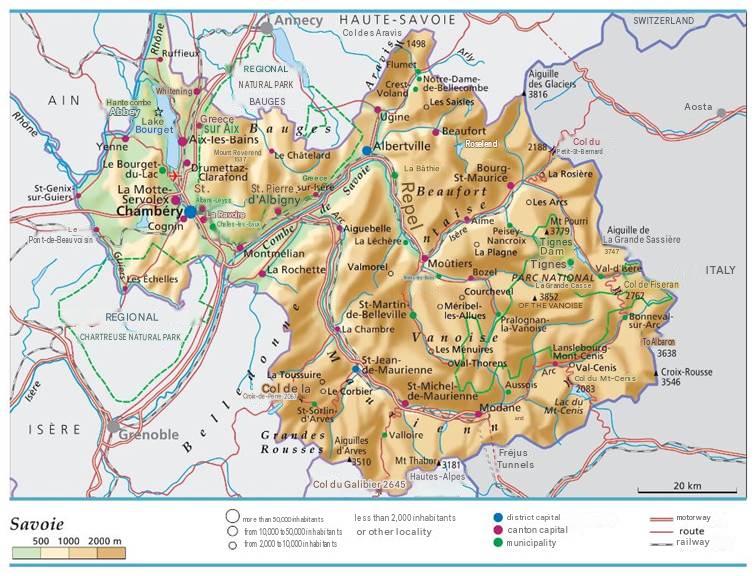
What you need to know about the Savoie department ?
We present to you the department 73, called Savoie. This department is located in the lower eastern half of the department. The region to which the Sarthe department belongs is: Auvergne-Rhône-Alpes. It is actually a department created in 1890 and its capital, which is also its main prefecture, is Chambéry. Its sub-prefectures, however, are: Albertville and Saint-Jean-de-Maurienne.
The administrative center and prefecture of the Savoie department is Chambéry, and its two sub-prefectures are Albertville and Saint-Jean-de-Maurienne. Regarding demographics, the department has a population of 455,152 (2026 estimate). With a total area of 6,028 km², the population density is approximately 75.5 inhabitants per km². Administratively, Savoie is divided into 3 arrondissements, 19 cantons, 17 intercommunal structures, and 273 municipalities.

Which departments border the Savoie department?
Since the Savoyard territory is an integral part of Auvergne-Rhône-Alpes, the neighboring departments are: the Haute-Savoie department which borders it to the north. Then, there is the Ain department which borders it to the west, the Isère department which borders it to the southwest, the Hautes-Alpes department which borders it to the south. But Savoie also shares borders with Italy via the Susa and Aosta valleys.
What is the climate like in the Savoie department?
Given the altitude of the territory occupied by Savoie, that is around 1500m, its climate is therefore mountainous. However, the Savoyard climate is not constant; three climatic variations are observed:
- The first is an oceanic type climate: which is strongly characterized by climatic disturbances (storms, winds, etc.)
- The second is a continental type climate: this type of climate is characterized by very cold winters and much warmer summers.
- Finally, there is the Mediterranean type climate which is mainly characterized by a lot of heat and a dry summer period. Moreover, unexpected heat waves occur.
In the eastern section of Savoie, there is what is called the “east return,” which actually refers to snowfall only in the eastern section. This is probably caused by Foehn effects.
Precipitation levels are acceptable and Savoie is not among the departments that suffer from water shortages during heatwaves. Nevertheless, unlike the Bauges and Chartreuse, which are mostly subject to destabilizing influences and western storms, some regions of the department have a warmer, sunnier environment less dependent on precipitation, such as the Maurienne valley.
Moreover, Savoie generally has a much warmer and drier environment than Haute-Savoie, which is more dependent on the maritime environment that brings snow and vegetation. Savoie has some peaks of 3,000 meters, so it has a snow level and consequently regular snowfalls, including glaciers.
Important mountain passes, notably the Galibier, the Iseran, or the Petit Saint-Bernard, are closed for a certain period during the coldest part of the year due to blockage caused by heavy snow.
What are the most important cities in the Savoie department?
At the level of the best cities for tourist destinations, that is to say the most visited cities by tourists in the 73, we count:
- Chambéry
- Aix-les-Bains
- Albertville
- Jacob-Bellecombette
- Barberaz
- Beaufort
- La Motte-Servolex
- La Ravoire
- Ugine
- Entrelacs
- Brison-Saint-Innocent
What are the most important municipalities in the Savoie department?
As for this ranking of municipalities in the Haute-Savoie part of the department, we grouped them according to area in km2:
- Bourg-Saint-Maurice
- Beaufort
- Valloire
- La Léchère
- Val-d’Isère
- Les Belleville
- Val-Cenis
- Bessans
- Sainte-Foy-Tarentaise
- Pralognan-la-Vanoise
To make this list, we tried to consider the occupant density per km2 of each municipality in Savoie:
- Chambéry
- Albertville
- Saint-Jean-de-Maurienne
- La Ravoire
- Cognin
- Challes-les-Eaux
- Aix-les-Bains
- La Motte-Servolex
- Bourg-Saint-Maurice
- Ugine

FAQ: Savoie map
The department’s official website provides a comprehensive interactive map. You will find road networks and municipal boundaries there.
Yes, all ski areas are clearly located on the map. These sites are highlighted with appropriate symbols.
It is possible to download the map in a digital format. You will then be able to view it without internet access.
