
What you need to know about Ivory Coast ?
Ivory Coast is a unitary constitutional republic with a presidential system.
- The area of its territory is 322,462 km².
- The population is estimated at about 29.3 million inhabitants in 2025, with an average density of ~91 inhabitants/km².
The country has two capitals:
- Abidjan, the economic capital and largest city,
- Yamoussoukro, the political and administrative capital.
Among other major urban centers are Bouaké, Daloa, Korhogo, and San Pedro.
The official language is French.
The international telephone code for Côte d’Ivoire is +225.
Table – Ivory Coast : geographic and demographic information
| Element | Key Information |
|---|---|
| Total area | 322,463 km² |
| Political capital | Yamoussoukro |
| Economic capital | Abidjan |
| Neighboring countries | Liberia, Guinea, Mali, Burkina Faso, Ghana |
| Coastline | ~515 km on the Atlantic Ocean (Gulf of Guinea) |
| Estimated population | ~30 million inhabitants (2025) |
| Population density | ~93 inhabitants/km² |
| Relief | Tropical forests in the south, savannas in the north, mountains in the west |
| Climate | Humid equatorial in the south, dry tropical in the north |
| Official language | French |
| Economic resources | Cocoa (world’s largest producer), coffee, oil, gold |
| Special feature | Flagship country of West Africa, with Abidjan as a regional metropolis |

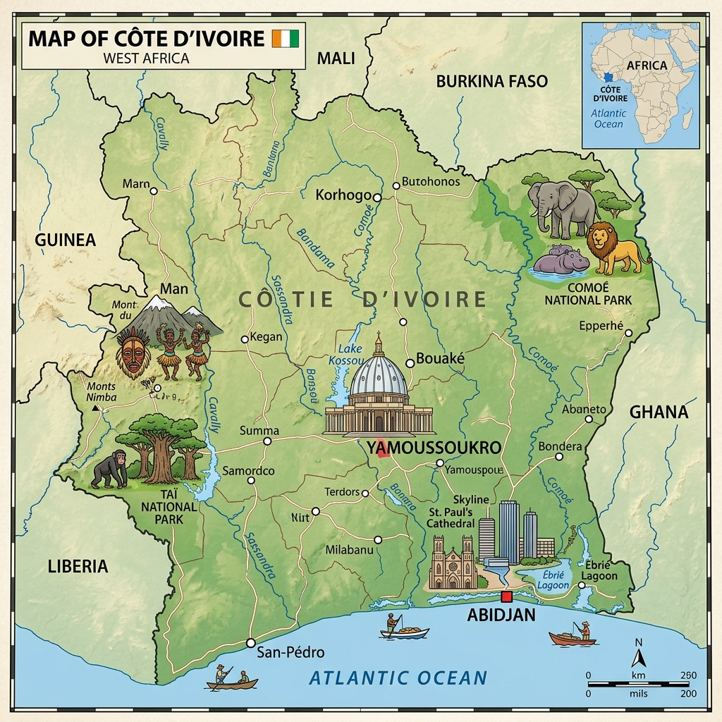
Additional points on the map of Ivory Coast
- Located in West Africa, Côte d’Ivoire has a wide maritime frontage on the Atlantic.
- The south is covered with dense forests and plantations, while the north is dominated by savanna.
- The country borders five states: Ghana, Burkina Faso, Mali, Guinea, and Liberia.
- Abidjan is a major economic center of the Gulf of Guinea.
- The demographic map shows a high population concentration in the south and along the coast.
Colors of Ivory Coast
The Flag of Côte d’Ivoire has 3 colors arranged in horizontal bands from left to right: orange, white, green. The colors represent the savannas and fertility, peace and hope, as well as the southern forests of Côte d’Ivoire.

Main cities and best places to visit in Ivory Coast?
Yamoussoukro: It is a very spacious city with several government buildings and hotels of various classes. You will also see sites such as the Basilica of Our Lady of Peace as well as several monuments reminiscent of Rome.
Abidjan: It is a very touristy coastal city with beautiful alleys and several lively neighborhoods, notably the Central Plateau. There is also the Saint Paul Cathedral and the national museum.
Man: It is a city highly appreciated by hikers and thrill-seekers. There are several mountains to climb, natural forests, and a famous waterfall. It is also the country’s largest cocoa-producing city.
Where is Ivory Coast located on the world map?
Côte d’Ivoire is a state located in Africa. On the African continent, it is situated in the Gulf of Guinea and slightly shifted towards the west. The neighbors of Côte d’Ivoire are Mali and Burkina Faso to the North, Guinea and Liberia to the West, and to the Southwest, Ghana to the East.

Climate of Ivory Coast
The climate of Côte d’Ivoire is a mix of equatorial and moderate tropical climates. On the coast, the climate is moderately arid with varying temperatures in the North and South. The average annual temperature is 28°C. The climate below the equator is moderately tropical, meaning temperatures range between 25 and 30°C.
The annual rainfall is high, ranging from 1,700 to 2,100 mm. In the south of the country, temperatures range between 14 and 33°C with an annual rainfall of 1,200 mm. Throughout the territory, there are two types of seasons: between November and June (sometimes in April) the dry season, and between July and October a rainy and cool season.
Administrative division of Ivory Coast

The territory of Côte d’Ivoire is divided into 14 districts, two of which are cities considered autonomous districts:
- Abidjan
- Bas-Sassandra
- Comoé
- Denguélé
- Gôh-Djiboua
- Lacs
- Lagunes
- Montagnes
- Sassandra-Marahoué
- Savanes
- Vallée du Bandama
- Woroba
- Yamoussoukro
- Zanzan
The remaining 12 non-autonomous districts are divided into 31 regions (second level):
- N’Zi
- Iffou
- Aries
- Moronou
- Indénié-Djuablin
- South Comoé
- Folon
- Kabadougou
- Gôh
- Lôh-Djiboua
- Agnéby-Tiassa
- Mé
- Grands Ponts
- Tonkpi
- Cavally
- Guémon
- Haut-Sassandra
- Marahoué
- Poro
- Tchologo
- Bagoué
- Nawa
- San-Pédro
- Gbôklé
- Hambol
- Gbêkê
- Béré
- Bafing
- Worodougou
- Bounkani
- Gontougo
Both (autonomous districts and regions) are divided into 108 departments (3rd level). The 4th level consists of 510 sub-prefectures. The prefectures are then split into 197 communes (5th level).

The Ivorian economy mainly relies on agriculture, particularly cash crops: cocoa (for which Côte d’Ivoire is the world’s leading producer and exporter) and coffee, but also cashew nuts, palm oil, and cotton.
Industry accounts for about 20% of GDP, dominated by oil extraction, refineries, and agro-industry (processing of cocoa, coffee, and oils). The country also focuses on services (telecommunications, finance, transport), which are rapidly developing.
Economic data (2025)
- Currency: CFA franc (XOF)
- Nominal GDP: ~86 billion USD
- GDP (PPP): ~205 billion USD
- Annual GDP growth: ~6.5%
- GDP per capita (PPP): ~6,500 USD
- Inflation: ~4%
- Population below poverty line: ~39% (significantly down from 65% fifteen years ago)
- HDI: ~0.55 (world ranking around 160th place, improving)
- Official unemployment rate: ~3% (but significant underemployment, especially among youth)
- External debt: ~22 billion USD
Population and linguistic data of Ivory Coast
- Total population (2025): ~29.3 million inhabitants
- Annual growth: ~2.3%
- Fertility rate: ~4.4 children per woman
- Birth rate: ~32 ‰
- Mortality rate: ~7 ‰
- Life expectancy: ~61 years (59 years men, 63 years women)
- Median age: ~19 years (very young population)
- Sex ratio: ~102 men per 100 women
Main ethnic groups
- Akan: ~39%
- Mandé: ~28%
- Krou: ~22%
- Voltaic (Gur): ~10%
- Other minorities: ~2%
Religions
No religion: ~13%
Islam: ~43%
Christianity (Catholic and Protestant): ~34%
African traditional religions and others: ~10%
FAQ – Ivory Coast map: 3 questions
In West Africa, with a coastline on the Atlantic Ocean and borders with Ghana, Burkina Faso, Mali, Guinea, and Liberia.
The political capital is Yamoussoukro, but the economic capital and largest city is Abidjan.
A marked contrast between the tropical forests in the south, the savannas in the north and the mountains in the west, with a coastline of more than 500 km.
