
What You Need to Know About Cameroon
Cameroon is a country located in Central Africa and is also called the Republic of Cameroon. The capital and largest city is Yaoundé. Its largest cities are Douala, Garoua, Bamenda, Bafoussam, Maroua.

The total area of Cameroon is 475,440 km² and its population is estimated at about 29.5 million inhabitants in 2025.
The country is thus the 51st most populous and the 53rd largest in the world.
The inhabitants, called Cameroonians, mainly speak French and English, which are the two official languages.
The international telephone code for Cameroon is +237 (or 00237).
Table – Cameroon: Geographic and Demographic Information
| Element | Key Information |
|---|---|
| Total area | 475,442 km² |
| Political capital | Yaoundé |
| Economic capital | Douala |
| Neighboring countries | Nigeria, Chad, Central African Republic, Congo, Gabon, Equatorial Guinea |
| Coastline | ~400 km on the Atlantic Ocean (Gulf of Guinea) |
| Estimated population | ~30 million inhabitants (2025) |
| Population density | ~63 inhabitants/km² |
| Relief | Mountains (Mount Cameroon 4,095 m), high plateaus, plains, savannas |
| Climate | Equatorial in the south, tropical in the center, semi-arid in the north |
| Official languages | French, English |
| Economic resources | Oil, timber, cocoa, coffee, agriculture |
| Particularity | Nicknamed “Africa in miniature” for its geographical and cultural diversity |
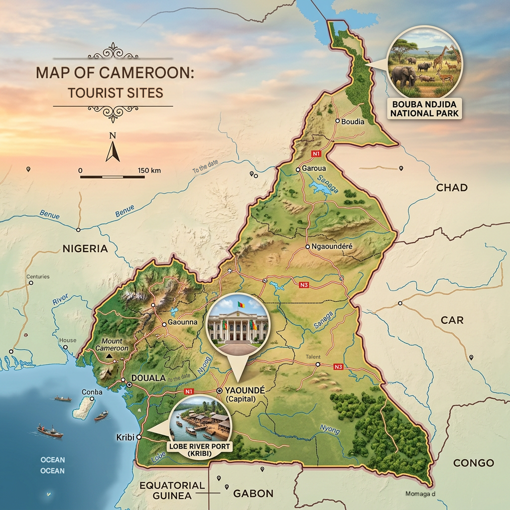
Additional Points on the Map of Cameroon
- Cameroon is located in Central Africa, with a maritime frontage on the Gulf of Guinea.
- Its physical map reveals varied landscapes: coastline, mountains, savannas, and tropical forests.
- Mount Cameroon is the highest point in the country and in West Africa.
- Yaoundé is the political capital, while Douala is the major economic and port center.
- Its geographical and cultural diversity earns it the nickname Africa in miniature.
Cameroon’s Neighboring Countries
The map of Cameroon highlights a Central African country, bordered by Nigeria to the west, Chad to the north, the Central African Republic to the east, as well as Congo, Gabon, and Equatorial Guinea to the south. Its opening onto the Gulf of Guinea makes Douala a strategic economic center.
The Colors of Cameroon
The flag of Cameroon is a rectangular flag composed of 3 horizontal stripes. From left to right: there is green, red, and yellow. In the middle of the central red stripe, there is a yellow 5-pointed star.

These colors represent the Pan-African colors. Red represents the blood shed by the people during the struggle for independence, yellow is the sun above the savannah, and green represents the equatorial forest. The yellow star represents the unity of the state and indivisibility.
The Best Cities in Cameroon
Yaoundé
Yaoundé is the political capital of Cameroon, and its visit holds many pleasant surprises. The city stretches over a succession of lush hills; it is sometimes called the “city of seven hills,” which gives it a unique relief and character. The imposing government buildings, embassies, and international institutions give it the appearance of a modern African capital. I strolled through the lively streets of the center, visited the national museum, and enjoyed the colorful local markets. Contrary to what one might think, it is a relatively green and pleasant city to explore.
Douala
Douala is the economic engine of Cameroon, and you can feel it as soon as you set foot there! The country’s largest city in terms of population and economic activity, it hosts the main international port of the sub-region and an international airport, making it the country’s gateway. The bustling docks, the lively markets like the Grand Marché and Sandaga market, the beaches of the Wouri estuary… Douala has a raw and fascinating energy. Street vendors and hawkers put on a show at every corner, offering a total immersion in Cameroonian life.
Maroua
Maroua is a unique city, far from the usual tourist circuits, and that is precisely what makes it interesting! Capital of the Far North region, it charms with its red and sandy dirt alleys, ochre-toned buildings, and typical Sahelian architecture that gives the impression of being in another country. The covered markets of Maroua are among the liveliest in Cameroon, with crafts, fabrics, spices, everything can be found there. The city is also an excellent starting point to explore the Mandara mountains, the surrounding national parks, and the traditional villages of the Grand North, rich in history and traditions.
Financial Map of Cameroon
Cameroon has a diversified economy, marked by a strong presence of foreign companies that have contributed to its industrialization. You can find:
- processing industries (wood, cotton, cocoa, aluminum),
- oil refineries and activities related to hydrocarbons,
- agro-food industries (coffee, cocoa, banana, palm oil),
- steel industry and manufacturing of consumer goods.
However, the economy remains vulnerable due to dependence on raw material exports and a very large informal sector.
Economic Data (2026)
- Currency: CFA Franc (XAF)
- Nominal GDP : ~53 billion USD
- GDP in PPP : ~160 billion USD
- Annual GDP growth : ~4 %
- GDP per capita (nominal) : ~1,800 USD
- GDP per capita (PPP) : ~5,400 USD
- Inflation : ~4 %
- HDI : ~0.56 (about 25th in Africa, 151st worldwide)
- Official unemployment rate : ~6 % (but underemployment affects nearly 70 % of the active population, especially the youth)
Climate Map of Cameroon

The climate of Cameroon is quite varied given the size of its territory. A tropical climate is observed in the northern part of the country. However, as one moves inland, the climate becomes arid desert.
The country’s climate is strongly influenced by the Harmattan, which is a hot desert wind from the Sahara, especially during hot and dry periods. In the southern part of the country, the dry season is short with frequent rains.
During this period, there is an alternation of sunshine and cloudy skies. The southwestern section, notably the capital and its neighbors, are the rainiest areas of Cameroon. Conversely, this type of climate is suitable for the vegetation that is well developed there.
Thus, enjoy the cool cities, notably Bamiliké and Bamoun. You can also enjoy the warmth of Kribi all year round, which allows swimming at any time. However, it is advised not to visit the country between July and October as the hot temperatures often accompany humidity.
Demographic, Demolinguistic and Administrative Map of Cameroon
Demography
The population of Cameroon currently stands at 27,744,989 inhabitants with a demographic growth rate of 2.54% and a fertility rate of 4.58 children per woman. The birth rate is higher than the death rate, being respectively 35‰ and 9.4‰.
The life expectancy of a Cameroonian at birth is quite low, around 59.4 years, with 58 years for women and 60.9 years for men. The average age in the country is 18.6 years, indicating an extremely young population. The male/female sex ratio is 101%, and the migration rate is -0.1%.
Administrative divisions of Cameroon
Cameroon is divided into 10 semi-autonomous regions managed by a regional council administration. These regions are further subdivided into 58 divisions or departments. The regions of Cameroon are:
- Far North
- North
- Adamaoua
- Northwest
- Southwest
- Littoral
- West
- Center
- East
- South
Here are the departments of Cameroon:
Adamaoua Region
- Djérem
- Faro-et-Déo
- Mayo-Banyo
- Mbéré
- Vina
Centre Region
- Haute-Sanaga
- Lekié
- Mbam-et-Inoubou
- Mbam-et-Kim
- Méfou-et-Afamba
- Méfou-et-Akono
- Mfoundi
- Nyong-et-Kéllé
- Nyong-et-Mfoumou
- Nyong-et-So’o
East Region
- Boumba-et-Ngoko
- Haut-Nyong
- Kadey
- Lom-et-Djérem
Far North Region
- Diamaré
- Logone-et-Chari
- Mayo-Danay
- Mayo-Kani
- Mayo-Sava
- Mayo-Tsanaga
Littoral Region
- Moungo
- Nkam
- Sanaga-Maritime
- Wouri
North Region
- Bénoué
- Faro
- Mayo-Louti
- Mayo-Rey
Northwest Region
- Boyo
- Bui
- Donga-Mantung
- Menchum
- Mezam
- Momo
- Ngo-Ketunjia
West Region
- Bamboutos
- Haut-Nkam
- Hauts-Plateaux
- Koung-Khi
- Menoua
- Mifi
- Ndé
- Noun
South Region
- Dja-et-Lobo
- Mvila
- Océan
- Vallée-du-Ntem
Southwest Region
- Fako
- Koupé-Manengouba
- Lebialem
- Manyu
- Meme
- Ndian
Demolinguistic Data

The official languages in Cameroon are English and French. However, there are native languages that come from a mix of Niger-Congo, Saharan, Bantu, and Afro-Asiatic families. Most national languages are not written or are rarely written, which is why the Administration has adopted Anglophone and Francophone languages as official.

The Cameroonian ethnic groups consist of:
- Fangs
- Bamilékés
- Bamouns
- Douala
- Loumdou
- Bassa
- Peuls
- Tikars
- Mandara
- Maka
- Chamba
- Mbums
- Haoussa
FAQ – Cameroon map: 3 questions
Cameroon is located in Central Africa, between West Africa and the Congo Basin.
The political capital is Yaoundé, while the economic capital is Douala.
It has a coastline on the Atlantic, Mount Cameroon, savannas in the north, and tropical forests in the south.
