
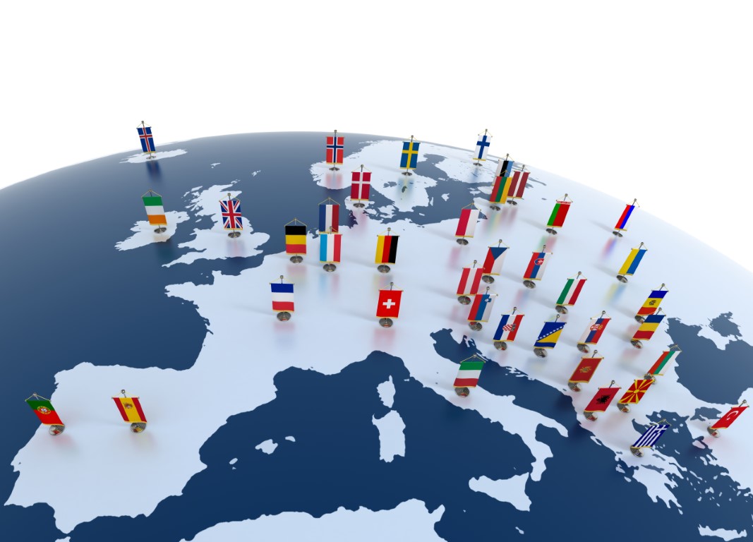
Bound to the north by the Arctic Ocean, to the south by the Mediterranean Sea, to the east by Asia, and to the west by the Atlantic Ocean, the Europe map is relatively simple to create.
The European continent covers an area of approximately 10.2 million square kilometers. Its population is now estimated at around 745 million inhabitants, with an average population density of about 73 people per square kilometer, although this varies considerably from one country or region to another.
On the Europe map, several islands or archipelagos attached to the continent can be found. These are: the Azores (Portugal), Iceland, the Canary Islands (Spain), and also Svalbard (Norway). Discover useful information here about the Europe map.
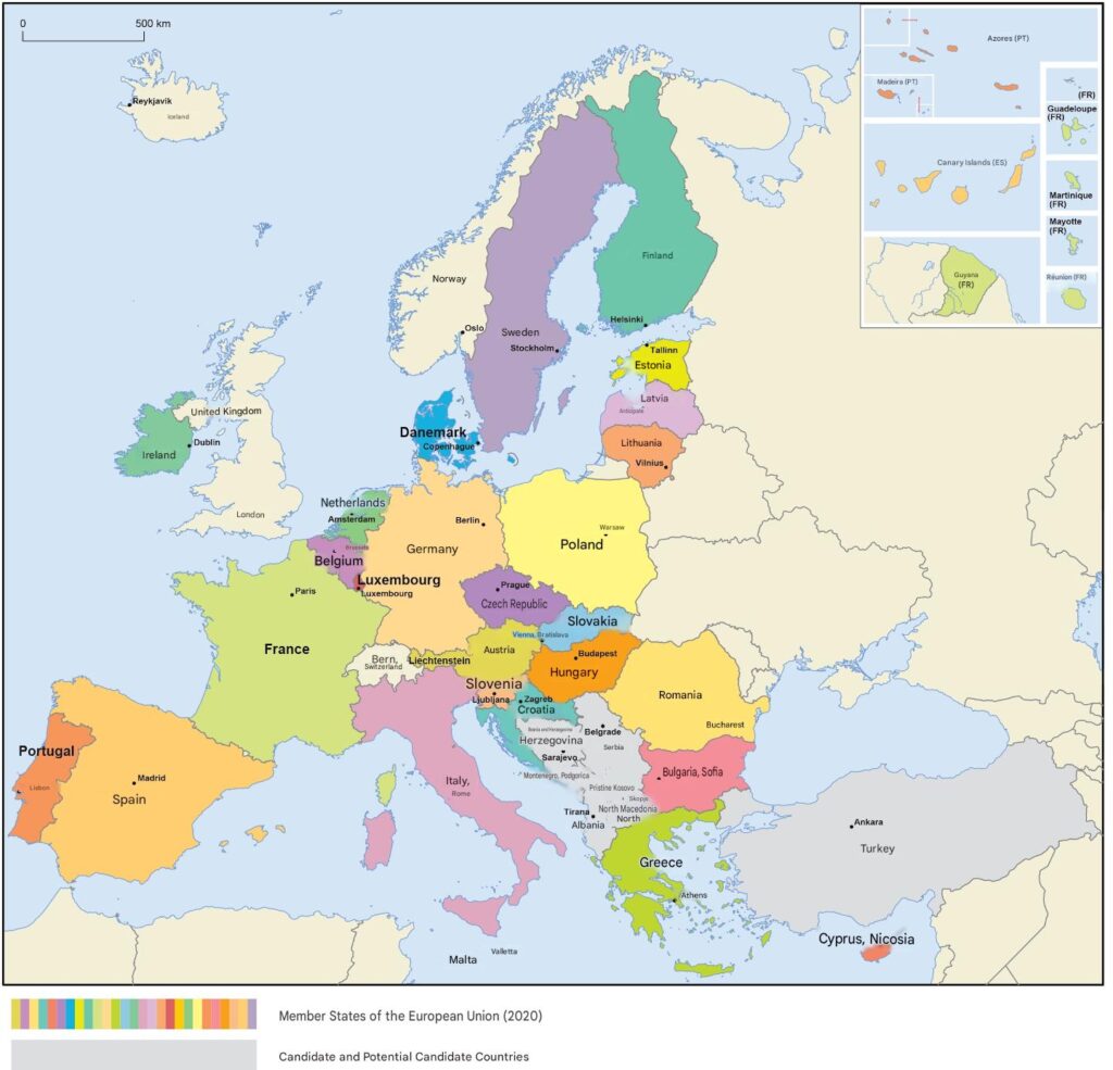
Europe map: an overview of the old continent
In history and geography, Europe forms Eurasia together with Asia. Indeed, geographers consider that the border between Europe and Asia corresponds to the Ural Mountains and the Ural River. It extends to the Caspian Sea and the Bosphorus Strait with a small part of Turkey. Note that the Caucasus is sometimes included. Russia is also considered a European country, even though it is mostly in Asia.
Politically, Europe is considered one of the supercontinents derived from Eurasia and Afro-Eurasia. It is also called the “Old Continent“, in contrast to the “New World” of Christopher Columbus. Culturally, Europe has been strongly influenced over the ages.
Even today, this continent includes several countries with a common heritage but linguistic and religious differences. Countries like France, Germany, Greece, and the United Kingdom are increasingly influenced by the phenomenon of globalization.
A community of peoples and different states tries to maintain the original unity of the old continent. Proof of this is the European Union, created in 1993, whose motto is “united in diversity“.
Although conflicts of interest today push some countries to leave or consider leaving this union, candidate countries have been mentioned in recent years.

Indeed, Europe remains an example in terms of political organization and democracy. The stages of construction of this part of the world have evolved over time. In the past, several states dominated and colonized many countries worldwide.
Today, countries like France, the United Kingdom, Spain, Estonia, Finland, Germany, Portugal… contribute in their own way to European construction. History and geography as presented in post-secondary courses attribute to Europe the greatest upheavals in the world.
List of countries in Europe and maps of each European country:
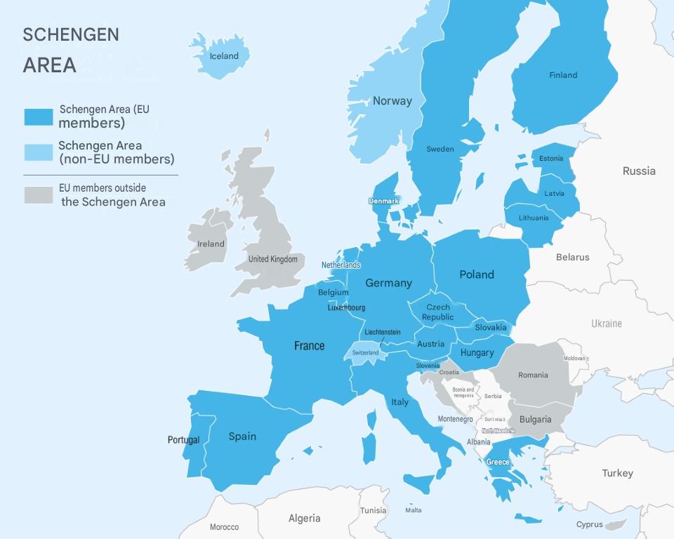
List of Schengen Area States
Other European countries
- Germany
- Austria
- Belgium
- Denmark
- Spain
- Estonia
- Finland
- France
- Greece
- Hungary
- Iceland
- Italy
- Latvia
- Liechtenstein
- Lithuania
- Luxembourg
- Malta
- Norway
- Netherlands
- Poland
- Portugal
- Slovakia
- Slovenia
- Sweden
- Switzerland
- Czech Republic
Listing all the countries of Europe can be a bit complex due to the different geopolitical definitions of Europe, but here is a generally accepted list of European countries:
- Albania
- Germany
- Andorra
- Armenia
- Austria
- Azerbaijan
- Belarus
- Belgium
- Bosnia and Herzegovina
- Bulgaria
- Cyprus
- Croatia
- Denmark
- Spain
- Estonia
- Finland
- France
- Georgia
- Greece
- Hungary
- Ireland
- Iceland
- Italy
- Kazakhstan (partly in Europe)
- Kosovo
- Latvia
- Liechtenstein
- Lithuania
- Luxembourg
- North Macedonia
- Malta
- Moldova
- Monaco
- Montenegro
- Norway
- Netherlands
- Poland
- Portugal
- Czech Republic
- Romania
- United Kingdom
- Russia (partly in Europe)
- San Marino
- Serbia
- Slovakia
- Slovenia
- Sweden
- Switzerland
- Turkey (partly in Europe)
- Ukraine
- Vatican City (Holy See)
Some of these countries, like Russia and Kazakhstan, have territories that extend both in Europe and Asia, while others, like Cyprus and Armenia, are culturally and historically linked to Europe but are geographically located in Asia Minor or the Near East.
Europe map: Geopolitical boundaries
When looking at a map of Europe, it becomes clear that the continent’s eastern boundaries remain partly conventional. Unlike its other borders, they are not entirely defined by seas or mountain ranges, which is why the separation between Europe and Asia is based on a combination of geographical, historical, cultural, and political criteria.
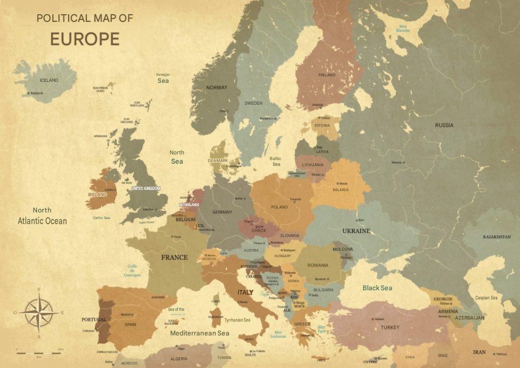
Today, the most widely accepted boundary follows the Ural Mountains, the Ural River, the Caspian Sea, the Greater Caucasus mountain range (depending on the convention used), the Black Sea, the Bosporus Strait, the Sea of Marmara, and the Dardanelles Strait. This definition has evolved over centuries as geographical knowledge and international conventions have developed.
Several countries are considered transcontinental because they extend across both Europe and Asia. These include Russia, Türkiye, Georgia, Azerbaijan, and Kazakhstan (for a small portion of its territory). Their association with Europe may vary depending on the geographical, historical, cultural, or political context.
Russia is the largest transcontinental country, with territories in both Europe and Asia, while Türkiye is divided between its European region, Eastern Thrace, and its Asian region, Anatolia, by the Bosporus Strait. These characteristics make the Europe–Asia boundary one of the world’s most unique and widely debated continental borders.
Europe map: Locations and peninsulas
In general, the scale of the Europe map is reduced. However, Europe’s small dimensions are compensated by a central position on the world map. On the Europe map background, the old continent appears as a peninsula of Asia, located opposite America. It is largely attached to Africa and is separated from it only by a small strait (Gibraltar).
Due to the strong presence of seas inland, Europe’s maritime fronts are very developed. In total, Europe has 32,000 km of coastline, including 12,700 km of Mediterranean shores and 13,500 km of Atlantic coasts. On the Europe country map, the North Cape is located in Norway at a great distance from France and the countries Poland Portugal. It is indeed the northernmost part of the European continent.
On a Europe map, the southernmost part is at Punta de Tarifa in southern Spain, near Gibraltar. After the Mount Elbrus (5,642 m) located in the northern Caucasus on the Russia Europe map, Mont Blanc (4810m) is the highest peak in Europe. It is located in France, more precisely in the Alps. It should be noted that the lowest area in Europe is the depression housing the Caspian Sea. As can be seen on the Europe map, the continental mass is cut by several large peninsulas. These include:
- the Iberian Peninsula;
- the Balkan Peninsula;
- Italy;
- Scandinavia.
It should be noted that other, smaller peninsulas also serve to delimit the Europe map. These include the Jutland and Brittany peninsulas. In general, the Europe map includes two large island groups. One is located in the Mediterranean Europe basin and the other is in the Atlantic.
The different types of Europe maps
The Europe map is a file used to indicate the geographical location of the member countries of this part of the world. On Amazon, for example, you will find different versions of Europe maps to choose from depending on your objectives. Depending on your needs, you can download or purchase a:
Road map: a European road member state necessarily belongs to the European road network.

According to the provisions of a European agreement dating from 1975, it is the Economic Commission for Europe that is responsible for numbering the roads.
They benefit from an unchanging numbering system for all member states of the European Union.
Overall, Europe offers many possibilities for road trips. To set off, equip yourself with a compass and a road map.
These items will help you follow your route well. To fill up on emotions, you don’t need to go far.
You can, for example, follow the Côte d’Azur to reach Italy while enjoying a beautiful landscape.
A relief map: with 56 sovereign states, Europe is marked by many political, cultural, and economic contrasts. Overall, the relief is more or less rugged and favors isolation and population density, even overpopulation in some member countries of the European Union and certain regions.
Urban areas predominate in Central and Western Europe. The oldest rock formations on the planet are found in the mountain ranges located in the northern part of the continent.
Although the Alps are recent, they are also present and extend over several European countries. On the Europe map, you can easily identify a mix of mountains, hills, plateaus, and plains.
It should be noted that there is also a significant number of rivers visible on a Europe map background.
An administrative map
Administratively, Europe is divided into four parts that are easy to find on a map background. Eastern Europe includes countries like the Czech Republic, Romania, Yugoslavia, etc. The western part of Europe represents the industrial heart of the continent. Indeed, there are highly urbanized states such as France, Germany, Andorra, Austria, Belgium, the United Kingdom, Ireland, and others. The landscape of Northern Europe is strongly influenced by glaciation. In this part, you find all the member states of Scandinavia and a few others.
A poster map
If you want to have an aerial view of the whole of Europe, you just need to get a poster map.
Depending on your needs, this version of the map allows the addition of objects, texts, regions, and others to easily locate yourself on a Europe map background.
An educational map
Designed to meet educational purposes in preparatory classes and schools, this version of the map is available in several formats.
It provides interesting information about Europe and is an effective tool for preparatory classes and CPGE schools.
A blank map
It allows you to see Europe from different angles. The blank or scratch-off Europe map especially allows travel enthusiasts to
There are also canvas maps, 3D maps, wall maps, and many others useful for post-secondary courses if you are considering a career as a geographer.
How to read a Europe map?
Reading a map of Europe means understanding its language and equipping yourself to decode it. To do this, you must rely on a certain number of elements. For better understanding, you first need to define the type of map you are looking at.

Next, you need to focus on the scale used and the text of the legend, not forgetting the symbols (point, area, line). Another thing to do is to question the missing elements and learn to make projections.
FAQ-Europe map : What you need to know
A map of Europe displays the countries of the continent, their borders, capitals, and major geographical features. It helps readers better understand the political and physical organization of Europe.
The number of European countries varies depending on the geographical and political criteria used. In general, Europe is considered to have around forty sovereign countries, along with several transcontinental states.
A map of Europe is useful for planning a trip, studying geography, or quickly locating a country. It also makes it easier to understand distances, borders, and the different European regions.
